Understanding the difference between a supercell and a tornado is essential for anyone interested in severe weather.
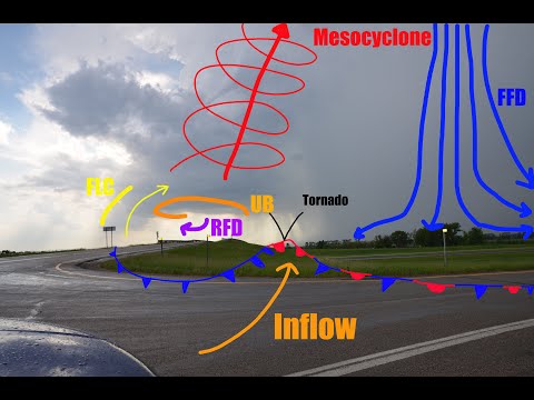
A supercell is a type of thunderstorm characterized by a rotating updraft, known as a mesocyclone. In contrast, a tornado is a violent rotating column of air that extends from a supercell to the ground. While not all supercells produce tornadoes, they are the most common storms to do so.
Supercells can last for hours and travel long distances, making them unique among thunderstorms. They have the potential to bring severe weather, including heavy rain, large hail, and damaging winds.
Tornadoes, on the other hand, form under specific conditions within these supercells and can cause devastating destruction in a matter of minutes. Understanding this relationship helps put the dangers of tornadoes into perspective.
Meteorologists emphasize the importance of monitoring supercell activity to anticipate tornado development. By doing so, individuals can better prepare for and respond to severe weather events. This knowledge is vital not only for weather enthusiasts but also for those who seek safety during storm season.
Understanding Supercells

Supercells are a type of thunderstorm that can produce severe weather, including tornadoes. They have distinct features that set them apart from other thunderstorms.
This section explores their characteristics, formation, types, and significance in weather prediction.
Characteristics of Supercells
Supercells are defined by their unique structure and behavior. They possess a deep rotating updraft known as a mesocyclone. This rotation is crucial for their ability to produce severe weather phenomena.
Supercells often have a wall cloud, a lowered area in the storm base where precipitation spirals upwards.
These storms can create significant hail, very strong winds, and even lead to flash flooding due to intense rainfall.
A typical supercell features a rear-flank downdraft, which is critical in the storm’s dynamics. This area can enhance the likelihood of tornado formation, making supercells particularly dangerous.
Formation and Structure
Supercells develop from larger scale weather systems, often initiated by an unstable atmosphere. The key is the presence of wind shear, which is the variation of wind speed and direction with height.
This change allows the storm to maintain its structure rather than dissipate.
The typical structure of a supercell includes a rotating updraft and a downdraft. The updraft is where moist air rises and cools, creating clouds and precipitation. Meanwhile, the downdraft results from cooling air sinking, bringing rain and potentially damaging winds.
The interaction between these elements results in a powerful storm capable of creating severe weather threats.
Types of Supercells
There are three main types of supercells: classic, high precipitation (HP), and low precipitation (LP).
- Classic supercells have a balanced mix of updraft and downdraft, creating a clear structure with heavy rainfall.
- High precipitation supercells produce a large amount of rain, which can obscure visibility and make it hard to see the storm’s rotation.
- Low precipitation supercells generate less rain and can be more deceptive, as they may appear more stable while still being capable of producing tornadoes.
Each type presents different hazards to those in their path.
Significance in Weather Prediction
Supercells are crucial for meteorologists when predicting severe weather events. Their ability to spawn tornadoes and cause other dangerous conditions makes them a focus of severe weather forecasts.
By monitoring the development of supercells, meteorologists can issue timely warnings.
Understanding the behavior of these storms helps in anticipating when and where severe events, like a tornado or flash flooding, might occur. This knowledge enables communities to prepare and respond effectively to potential threats, ultimately reducing the risk to life and property. Monitoring systems for thunderstorms and associated phenomena are essential for improving public safety in areas prone to severe weather.
Tornadoes and Their Relationship with Supercells

Tornadoes often form from supercell thunderstorms, which are known for their rotating updrafts. Understanding the connection between these two weather phenomena is key to predicting tornado occurrence and assessing their impacts.
Tornado Formation from Supercells
Most tornadoes develop during severe thunderstorms, particularly from supercells. A supercell is defined by a persistent rotating updraft, known as a mesocyclone. This rotation creates the wind shear necessary for tornado formation.
When the conditions are right—such as adequate moisture and instability—tornadoes can form. Strong winds can influence these formations. A hook echo on radar indicates a rotating storm that may produce a tornado.
Supercell tornadoes tend to be stronger and longer-lasting than those from multi-cell or single-cell storms. Weak tornadoes may also form from other storm types but are less common and less impactful.
Distinguishing Tornadoes from Supercells
It’s important to differentiate between tornadoes and supercells. A supercell is a type of thunderstorm that can produce tornadoes. Tornadoes are the actual rotating columns of air that touch the ground from these storms. Not every supercell produces a tornado, but tornadoes almost always originate in a supercell.
Meteorologists monitor radar for key signatures, such as the aforementioned hook echo, to predict tornado development. Factors like wind shear and storm-relative wind play crucial roles in these processes.
Impact of Tornadoes
Tornadoes can cause significant damage. Their wind speeds can range from weak (EF0) to violent (EF5).
Strong winds can lead to structures being torn apart and trees uprooted. Tornadoes can also create dangerous debris.
In regions like the Great Plains and Great Lakes, tornadoes are more frequent due to geographical conditions. Communities often face severe weather alerts and warnings from organizations like NOAA to prepare for potential tornado threats.
Monitoring and Safety Measures
Monitoring tornadoes involves using radar and weather satellites.
Meteorologists analyze storm behavior, looking for signs that indicate potential tornado formation.
Safety measures include having a weather plan and access to alerts.
Communities often conduct drills to prepare for tornadoes and educate the public on recognizing signs—in a storm like rotating clouds or a funnel cloud.
Staying informed through local news and weather apps is also vital.
Understanding surface movement and how it relates to storm patterns helps in assessments of risk during severe weather events.
By being aware of the relationship between tornadoes and supercells, people can take proactive safety steps.

