
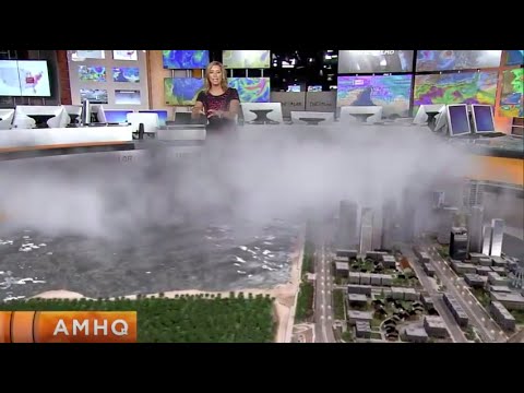
Lake effect snow is a fascinating weather phenomenon, especially for those living in the Great Lakes region.
It occurs when cold air moves over warmer lake waters, causing moisture to evaporate and then freeze as it rises into the colder air above. This process leads to heavy snowfall near the shores, creating a winter wonderland that can impact local communities significantly.
The presence of large bodies of water like the Great Lakes plays a key role in this winter weather event.
As the cold air absorbs moisture from the lake, it transforms into precipitation that falls as snow once the air cools down again. People in this region often experience intense snowstorms between November and February, which can disrupt daily life and travel.
Understanding why lake effect snow happens not only sheds light on meteorological patterns but also highlights the unique qualities of winter in the Great Lakes area.
For more information on related atmospheric phenomena, you can explore additional articles on atmospheric phenomena.
Formation of Lake Effect Snow
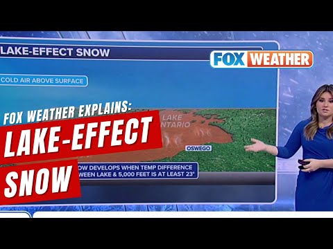
Lake effect snow occurs due to a combination of unique geographical features, temperature contrasts, and wind patterns. Understanding these factors helps to explain how heavy snowfall can happen in specific areas, particularly around the Great Lakes.
The Role of the Great Lakes
The Great Lakes provide a vast body of warm water.
When cold air moves across these warmer lakes, it picks up moisture. The temperature difference between the cold air and the warmer surface of the lake is crucial. This contrast creates instability, causing the air to rise. As it rises, the air cools and water vapor condenses, forming clouds that can produce significant snowfall on the leeward shores. In many cases, the Great Lakes can contribute to severe weather conditions, making regions nearby prone to heavy snowfall events.
Temperature and Moisture Dynamics
Temperature differences drive the formation of lake effect snow.
Cold, dry air from the north or west moves over the warmer waters of the lake, often raising the air temperature just above the surface. This allows the air to hold more moisture.
As the air continues to rise, it cools, leading to condensation. As the water vapor condenses into snowflakes, high relative humidity in the colder air enhances snowfall. This moisture release is pivotal, leading to the intense, localized snowbands typical of lake effect snow. Understanding these dynamics is essential to predicting where heavy snow will fall.
Wind Patterns and Direction
Wind plays a key role in lake effect snow formation.
Specifically, the direction and speed of the wind determine how much moisture the air picks up from the lake and where the snow will fall.
For effective lake effect snow, winds typically blow from the west or northwest across the lakes. These winds transport the moist air towards land, where it encounters colder temperatures. Patterns of wind circulation are influenced by larger weather systems and local geography, which can create variability in snowfall amounts. This complexity makes forecasting these snow events challenging but also fascinating.
Impacts and Predictions of Lake Effect Snow
Lake effect snow significantly affects local weather patterns and community life. It can produce heavy snowfall and dangerous conditions while challenging forecasting efforts. Understanding its impacts helps improve safety measures and preparedness for future events.
Weather Forecasting and Warnings
Predicting lake effect snow is complex due to its localized nature.
Forecasts from the National Weather Service focus on areas near the Great Lakes, where these events commonly occur. The forecasting process involves advanced radar technology and computer models to track cold air masses moving over warmer lake waters.
Lake-effect snowstorms can create sudden changes in visibility. Forecasters issue warnings when conditions are likely to worsen.
Heavy snow amounts can reach several feet, especially in regions like Buffalo, New York, and the Tug Hill region. Accurate predictions help prepare communities for storms, minimizing risks associated with rapid weather changes.
Lake-Effect Snow on Communities
Lake effect snow has significant impacts on communities like Buffalo, New York.
The heavy snowfall can lead to transportation disruptions, school closures, and difficulties for emergency services. Local governments must respond quickly to clear roads and ensure public safety.
Additionally, businesses may face challenges during severe snow events. Retailers and service providers might see decreased foot traffic, while snow removal services experience increased demand. The economic impact of lake effect snow can be profound, requiring careful planning and resource allocation.
Communities often adapt to seasonal snow patterns by enhancing infrastructure.
Strategies include improved snow removal equipment and investing in weather monitoring systems. By preparing ahead, areas prone to lake effect snow can mitigate some of its disruptive effects.
Climate Change and Future Trends
Climate change introduces uncertainty in predicting lake effect snow patterns.
Global warming may alter the temperature of lake waters, influencing evaporation rates.
Warmer conditions could lead to more intense snow events but may also result in reduced snowfall during milder winters.
The impact of climate change is particularly noticeable in regions like the Great Lakes.
As temperatures rise, the frequency and severity of lake-effect snowstorms may change.
Communities must adapt by reassessing their preparedness strategies for winter weather.
Understanding these trends is crucial for future planning.
Authorities and residents alike must stay informed about evolving climate patterns to better respond to lake effect snow events.
Monitoring and research will be vital in developing effective strategies for safety and community resilience.