The eye of a storm is a fascinating feature that often intrigues many.
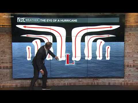
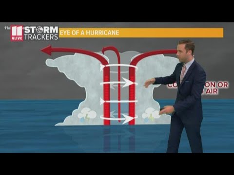
The eye forms as a result of the storm’s structure, where calmer winds and clearer skies exist at the center of a tropical cyclone. This calm area is surrounded by the eyewall, where the strongest winds and worst weather occur.
Understanding the formation of the eye helps demystify the behavior of hurricanes and other severe weather systems.
As a storm develops, various factors, such as wind speed and atmospheric pressure, play a role in creating this distinct area of calm.
The difference in pressure between the eye and the surrounding eyewall leads to the unique conditions found there. The eye can range from 20 to 40 miles across, offering a brief respite from the storm’s fury. However, entering this calm zone can mislead people into thinking the storm is over, making storms inherently deceptive.
By exploring why storms have eyes, readers can gain a deeper appreciation for the science behind these powerful weather systems.
Knowledge about the dynamics at play not only raises awareness but also promotes safety when severe weather approaches.
Physical Dynamics of Storm Eyes

The eye of a storm is a fascinating feature that plays a vital role in its behavior and strength. Understanding the physical dynamics that lead to its formation provides insight into how tropical storms and hurricanes develop.
Formation and Structure
The formation of the eye begins as a tropical storm strengthens, often through the release of latent heat. This process drives rising air, creating a low-pressure center.
As warm, moist air rises, it cools, forming thunderstorms around the center. The conservation of angular momentum causes the air to accelerate.
The eye itself is typically calm with clear skies, while the surrounding area forms an eye wall. This wall is where the most intense winds and rainfall occur.
The structure of the eye can vary; larger storms may have wider eyes, while rapidly intensifying storms can develop what is known as a pinhole eye. This phenomenon highlights the role of fluid mechanics in storm dynamics.
Meteorological Conditions
Meteorological conditions are crucial for the development and persistence of a storm eye.
Factors such as the Coriolis force affect how storms rotate, differing between the northern and southern hemispheres.
Tropical cyclones require warm ocean waters to maintain their energy, as these waters fuel the rising air.
Wind patterns and atmospheric pressure also play a significant role. As the storm moves, changes in speed can alter the size of the eye.
Slower storms tend to produce larger eyes, while faster movements result in smaller ones. Understanding these conditions helps meteorologists predict storm behavior and intensity.
For more on how wind influences weather systems, consider exploring Wind.
Impact and Observations

The eye of a storm presents a unique blend of calm and chaos. Understanding the contrasting conditions inside and outside the eye is essential for meteorologists. Observations about how an eye forms and evolves can also help predict storm strength and behavior.
Calm Center versus Violent Surroundings
The eye of a tropical cyclone is the calmest part of the storm. Inside the eye, air is sinking, creating light winds that typically do not exceed 15 mph (24 km/h). This area is often rain-free, providing a stark contrast to the surrounding eyewall, where violent winds and intense storms exist.
As a hurricane, such as Hurricane Wilma, strengthens, its eye can become larger and more defined. Meteorologists can observe “pinhole eyes,” which start small and expand during eyewall replacement cycles. Strong rotation in the eyewall can lead to significant changes in the storm’s intensity as the system progresses.
Tracking and Predicting Eye Evolution
Tracking the evolution of the eye is crucial for accurate forecasts.
Meteorologists use satellite imagery and radar to monitor changes in size and structure. They note when the eye grows larger and when the eyewall develops stronger updrafts, which can signal escalating winds.
Understanding these patterns helps in predicting potential hazards, including monster waves and storm surges.
The National Weather Service often updates warnings based on eye observations, advising the public about impacts.
Accurate tracking helps communities prepare for the worst while highlighting the importance of reliable weather data for safety during extreme weather events.

