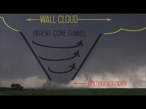
Thunderstorms come in many varieties, each with its own unique characteristics.
Among these, supercell thunderstorms stand out as the most powerful and dangerous. These storms are known for their rotating updrafts and are capable of producing severe weather events such as tornadoes, heavy rainfall, and hail.
Understanding the conditions that lead to these mighty storms involves examining factors like instability, moisture, and lifting mechanisms.
Supercells form when warm, moist air rises and cools, creating instability in the atmosphere. This instability, combined with a strong lifting mechanism, can lead to the formation of these potent storms.
Unlike ordinary thunderstorms, supercells can maintain their energy over extended periods, making them a significant threat to life and property.
The impact of supercell thunderstorms can be devastating, as they often spawn severe weather phenomena that pose risks to communities.
For those seeking to learn more about atmospheric phenomena, exploring the dynamics of these storms can provide deeper insights into the world of severe weather and its implications.
Anatomy of a Supercell Thunderstorm

Supercell thunderstorms are notable for their complex structure and intensity. They can produce various severe weather phenomena, including tornadoes, hail, and flash flooding.
Understanding the anatomy of a supercell involves looking at its characteristics, the influence of wind shear, and the severe weather associated with it.
Characteristics of Supercells
Supercell thunderstorms are defined by their unique structure, primarily the presence of a rotating updraft called a mesocyclone. This strong, persistent updraft allows these storms to last for several hours, unlike typical thunderstorms.
Supercells can be categorized into three types: classic, high-precipitation, and low-precipitation. The classic supercell has a well-defined anvil and a clear separation between the updraft and downdraft. High-precipitation supercells produce heavy rainfall and large hail, while low-precipitation supercells may have less rain but can produce significant tornadoes.
The strong updraft can reach heights of over 50,000 feet, leading to intense precipitation. The downdraft, in contrast, can create outflow boundaries that enhance storm development and contribute to severe thunderstorms.
The Role of Wind Shear
Wind shear is crucial in the formation of supercell thunderstorms. It refers to the change in wind speed or direction with height. This variation helps to create the rotating effect necessary for a supercell.
When winds at higher altitudes blow faster and in a different direction than those at the surface, the storm’s rotation becomes sustainable. This condition allows for better organization of the storm, leading to more severe outcomes.
The presence of wind shear can enhance the storm’s intensity, making it capable of producing damaging straight-line winds and tornadic activity.
Understanding wind dynamics is vital for forecasting severe weather events associated with supercells. Meteorologists monitor these conditions closely through advanced software and satellite data.
Severe Weather Associated with Supercells
Supercells are synonymous with severe weather. They can produce various hazardous phenomena such as tornadoes, large hail, and flash flooding.
Tornadoes often form when a supercell’s rotating updraft interacts with environmental conditions.
Hail can grow large due to repeated cycles of updraft and downdraft. The intense updraft keeps the hail aloft until it becomes too heavy and falls, causing damage.
Flash flooding can occur from heavy rainfall in a short time, overwhelming drainage systems. Supercells are notorious for creating derechos, which are widespread and long-lived wind events.
With these severe threats, monitoring and prediction become essential. Organizations like the Storm Prediction Center provide crucial alerts to help communities prepare and respond.
Types of Thunderstorms and Their Strength

Different types of thunderstorms exhibit varying strengths and characteristics. Understanding these differences is crucial for recognizing their potential impacts, including tornadoes, heavy rain, and lightning.
Multi-Cell Cluster Storms
Multi-cell cluster storms consist of several individual cells that form together. These storms typically develop along a gust front created by rain-cooled air.
Each cell can produce heavy rain, strong winds, and even weak tornadoes.
These storms often display a characteristic downdraft, leading to intense rainfall and potential flash flooding. Multi-cell storms can last several hours and may create squall lines, which are long lines of storms producing severe weather. The instability in the atmosphere fuels the convection needed for these storms to thrive.
Single-Cell Thunderstorms
Single-cell thunderstorms, also known as air-mass thunderstorms, are smaller and generally less severe. They form from localized heating during the day.
Typically, they are short-lived, lasting less than an hour.
These storms can produce brief periods of heavy rain and lightning but rarely cause significant damage. They may create weak tornadoes but typically do not lead to extreme weather conditions seen in larger storms. Their simple structure makes them easy to predict, but they can still surprise with sudden downpours.
Supercell Versus Derechos
Supercell thunderstorms are the strongest type, featuring a rotating updraft known as a mesocyclone.
Supercells can produce severe weather, including large hail, significant tornadoes, and high winds. Their structure allows for longer lifespans and more organized rotation compared to other storm types.
Derechos, on the other hand, are widespread, long-lived windstorms associated with bow echoes. They can generate severe straight-line winds that cause destruction over a large area.
While not as commonly linked to tornadoes, derechos still pose significant risks with heavy rain and powerful winds, making them dangerous weather phenomena to consider.
The impacts of these storms vary greatly, but both supercells and derechos hold the potential for severe weather events.
For those interested in electrical activity, thunderstorms like these can create significant occurrences of lightning, which can be both fascinating and hazardous.
More information on these events can be found in articles about electrical storms and surface movement.

