Thunderstorms are common weather events, but some are far more intense than others. The most violent type of thunderstorm on Earth is the supercell.
Supercells are uniquely powerful storms that can produce devastating lightning, large hail, and even tornadoes. These storms are characterized by a rotating updraft, allowing them to sustain themselves for hours while wreaking havoc in their path.
When conditions are right, supercells can unleash extreme weather, including hailstones larger than softballs and winds that can exceed 125 mph. The energy and structure within a supercell make it capable of creating severe thunderstorms, leading to significant destruction in affected areas.
Understanding these atmospheric phenomena helps in making informed decisions during severe weather warnings, ultimately improving safety and preparedness.
For those fascinated by electrical storms and their fury, exploring the dynamics of these powerful weather systems can be an eye-opening experience. The fierce nature of supercells and the severe thunderstorms that stem from them is a reminder of the incredible forces of nature at play.
The Supercell Thunderstorm

Supercell thunderstorms are known for their strength and longevity. They are the most violent type of thunderstorm on Earth, capable of producing severe weather events like tornadoes, damaging winds, and large hail.
Characteristics of Supercells
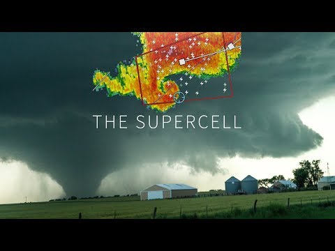
Supercells possess unique characteristics that set them apart from other thunderstorms. They typically have a rotating updraft known as a mesocyclone.
This rotation allows supercells to last for several hours, unlike conventional thunderstorms, which may only last for short periods.
The structure of a supercell includes a well-defined updraft and downdraft. The updraft pulls warm, moist air into the storm while the downdraft releases cooler, rain-cooled air. The balance of these elements creates a powerful storm capable of producing severe weather.
Formation and Structure
Supercells form in environments where warm, moist air meets cooler, dry air. This interaction leads to significant convection, causing the warm air to rise rapidly.
When the environmental winds are strong, the updraft can begin to rotate, forming the signature mesocyclone.
Classic supercells have a dome-shaped appearance with distinct features. The updraft is located in the rear of the storm, while the downdraft occurs in the front. This configuration promotes the organization and persistence of the storm, making supercells highly capable of producing tornadoes.
Identifying Supercells
Identifying a supercell can be crucial for safety. One main indicator is the presence of a rotating updraft. Other signs include the storm’s structure, which may show a hook echo on radar, indicating strong rotation.
Weather spotters look for specific cloud formations, such as the anvil cloud. The presence of a gust front, which is the leading edge of cool air produced by a storm, can also signal a supercell. These indicators can help meteorologists and the public prepare for hazardous weather events.
Supercell-related Weather Phenomena
Supercells are associated with several hazardous weather phenomena. They can produce strong tornadoes, with wind speeds reaching over 200 mph. These tornadoes can cause extreme damage to structures and landscapes.
Additionally, supercells often generate large hail that can damage vehicles and crops. They can also bring about flash flooding as heavy rain accumulates, especially in areas with poor drainage. Wind gusts from supercells can exceed 70 mph, leading to further destruction. The combination of moisture and convection in these storms makes them significant threats to safety.
The Impact of Severe Thunderstorms

Severe thunderstorms can have devastating effects on the environment and communities. These weather events can lead to significant flooding, cause damage to property, and pose serious risks to safety. Understanding their impacts helps to prepare for and mitigate their effects.
Effects on the Environment
Severe thunderstorms can result in intense flooding, especially in areas with poor drainage. Flash flooding can occur rapidly, transforming roads into rivers and overwhelming waterways. This flooding can damage ecosystems, wash away soil, and disrupt local wildlife.
In addition, severe thunderstorms may produce hazardous weather events such as hail and lightning. Lightning strikes can ignite wildfires, while hail can damage crops and infrastructures.
For example, microbursts may produce strong downdrafts that can uproot trees and damage structures. The combination of heavy rain and high winds can also erode riverbanks and disrupt aquatic habitats.
Socioeconomic Consequences
The socioeconomic impacts of severe thunderstorms can be severe. Flooding can lead to extensive property damage, affecting homes and businesses alike. Repairing such damage can be financially burdensome for families and insurance companies.
Additionally, severe thunderstorms can disrupt local economies. Businesses may need to close for repairs, and agricultural fields may be ruined, leading to decreased yields. The costs associated with recovery from such events can strain local budgets. Infrastructure damage can also hinder transportation and access to emergency services during critical moments.
Protective Measures and Safety
Preparation is key to minimizing the impacts of severe thunderstorms.
Communities can implement warning systems that alert residents to impending storms.
Individuals should create emergency plans that include safety kits containing essentials like water and first aid supplies.
Understanding water safety is crucial, especially with the risk of flooding.
In addition, maintaining proper drainage systems can help mitigate flooding.
Residents should be aware of safe places to shelter in case of severe storms.
Learning about different weather events and their characteristics helps people understand when to seek safety, enhancing community resilience.

