
Tornadoes are some of the most powerful and dangerous storms in nature. A key indicator of an impending tornado is the presence of specific cloud types, particularly wall clouds and funnel clouds. These formations often signal severe weather conditions, giving experienced meteorologists vital clues about what may be on the way.
Observing these clouds can be critical for safety and preparedness.
Before a tornado strikes, a wall cloud typically appears as a lowering under a storm cloud, often rotating. This area can indicate the strongest updraft within a storm, serving as a major warning sign.
Recognizing these signs can help individuals take necessary precautions.
Understanding temperature differences also plays a crucial role in tornado formation, as warm air rises and interacts with cooler air above.
Being aware of cloud formations can make a difference in survival during severe weather. By learning to identify these warning signs, people can better protect themselves and their families when storms roll in.
The fascinating world of meteorology continues to reveal how closely linked cloud patterns are to tornado activity, enhancing public safety before these storms develop.
Precursors to Tornadic Events
Before a tornado forms, specific conditions and cloud formations develop. Recognizing these signs is crucial for safety and preparedness.
Key indicators include storm development patterns and visible signs of tornado formation.
Storm Development
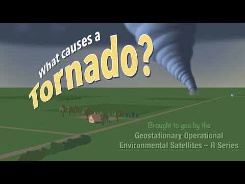
Tornadoes commonly form from severe thunderstorms, particularly supercells. These storms have a characteristic rotating updraft called a mesocyclone.
A strong wind shear, which is the change in wind speed and direction with height, is essential for creating the rotation needed for tornado formation.
Cumulonimbus clouds, which are tall and dense thunderstorm clouds, often precede tornadoes. As these storms develop, they can produce wall clouds. A wall cloud appears as a lowering of the cloud base and is often a sign that a tornado may form soon after.
During this stage, it is helpful to monitor local weather reports for tornado watches and warnings, as conditions can escalate rapidly.
Signs of Tornado Formation
Several visual signs indicate that a tornado is imminent. One significant precursor is the formation of a funnel cloud, which extends from a wall cloud. This cloud is a rotating column of air that has not yet reached the ground.
Additionally, increased surface winds may signify developing storm systems. These winds can lead to stronger updrafts and downdrafts, contributing to tornado formation.
Dust and debris being lifted into the air can also indicate the presence of a tornado.
Being aware of these precursors can substantially improve response times during severe weather events. Staying vigilant during storm conditions, especially with heightened wind activity, is key for safety.
For more on how surface movement affects storms, check Surface Movement.
Cloud Types and Tornado Risk
Different cloud types can indicate the risk of an approaching tornado. Understanding these formations helps in assessing storm conditions.
Specific clouds like wall clouds, scud clouds, and anvil clouds play a vital role in tornado development and are important for both storm chasers and spotters.
Tornado-Aligned Cloud Formations
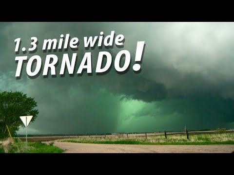
Several cloud types signal an increased tornado risk. The wall cloud is crucial; it forms under a thunderstorm’s main updraft and can produce funnel clouds. Often, these clouds are visible during severe storms, particularly in Tornado Alley.
Anvil clouds are also significant, appearing at the top of cumulonimbus storms, while shelf clouds can indicate strong downdrafts. A pedestal cloud may develop beneath these formations, suggesting that a tornado could be imminent.
Additionally, scud clouds, which are low, ragged clouds associated with a moist environment, can swirl ominously and sometimes resemble tornadoes.
Large hail and falling debris can accompany these cloud types, heightening the potential danger during storm conditions.
Advanced Indicators and Storm Chasing
For storm chasers and spotters, recognizing advanced indicators is essential.
Observing gust fronts can signal a change in wind and pressure, often leading to severe weather.
Furthermore, the presence of mammatus clouds may indicate instability in the atmosphere, making tornado formation more likely.
Spotters often watch for rapid cloud motion and any scud clouds near a storm. These conditions usually suggest that the storm is becoming more severe.
Understanding these signs contributes to more effective storm tracking and safety measures.
Storm chasers rely heavily on these indicators to assess their environments before they approach potentially dangerous situations, especially during tornado season.
For more insights on such atmospheric phenomena, exploring materials on atmospheric phenomena can be valuable.