
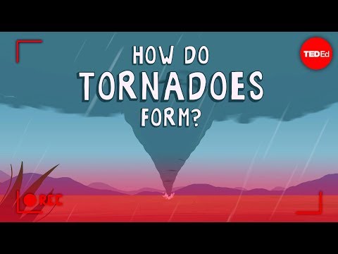
Supercell tornadoes are some of the most powerful and destructive storms in nature. These tornadoes form from supercell thunderstorms that have a rotating updraft known as a mesocyclone.
These storms are characterized by their unique structure and ability to produce severe weather, including large hail and damaging winds.
Understanding supercells is crucial for weather enthusiasts and anyone living in areas prone to severe storms.
The specific conditions required for a supercell to develop often occur in regions like Tornado Alley in the United States. The complex dynamics within these storms can lead to long-lived tornadoes that may travel great distances and cause extensive damage.
Supercell Thunderstorm Characteristics
Supercell thunderstorms are unique due to their structure and the powerful phenomena that occur within them. Understanding these characteristics helps in recognizing the potential for severe weather events, including tornadoes.
Mesocyclone and Rotating Updraft
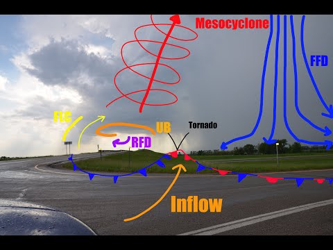
A mesocyclone is the central feature of a supercell storm. It is characterized by a deep, rotating updraft that creates a vertical wind vortex.
For a mesocyclone to form, there must be significant wind shear, which is the change in wind speed and direction with height. This variation causes the air to start rotating.
The presence of a rotating updraft allows for the development of severe weather. As air rises within the updraft, it cools and condenses, forming clouds.
Often, the hook echo can be observed on radar, indicating the presence of a mesocyclone. The bounded weak echo region (BWER) is a signature of strong updrafts found within these storms.
Storm Structure and Dynamics
Supercells have a well-defined structure that sets them apart from other thunderstorm types. They often contain a clear downdraft and an updraft that are organized in a rotating manner.
This structure includes a rear flank downdraft, which is the descending air located at the rear of the storm.
The v-notch is another key characteristic, appearing on radar as a notch in the echo structure. It indicates the area of rotation and strong updrafts.
The organization and persistence of these storms, often lasting over an hour, contribute to their ability to produce severe weather, including devastating tornadoes.
Impacts and Detection of Supercell Tornadoes
Supercell tornadoes can cause severe damage and pose significant threats to life and property. Understanding how these tornadoes form and how they can be detected is crucial for public safety. Below are key aspects of their impacts and detection methods.
Tornadogenesis and Life Cycle
Supercell tornadoes develop from severe thunderstorms known as supercells. These storms contain rotating wind patterns called mesocyclones.
Tornadogenesis occurs when the rotation tightens and extends downward, forming a funnel cloud that may reach the ground. Factors like wind shear and atmospheric instability contribute to this process.
Once formed, supercell tornadoes can vary in intensity and lifespan. They may produce strong winds that cause extensive damage.
A significant part of their life cycle includes downdrafts and the potential for flash flooding, especially if there is heavy rain along with hailstones. Monitoring these elements is vital to understand the storm’s behavior.
Forecasting and Monitoring
The detection and forecasting of supercell tornadoes rely heavily on advanced technology. Doppler radar is crucial, as it helps identify key radar features like hook echoes, which indicate rotating updrafts.
The National Weather Service (NWS) uses this technology to issue timely alerts.
Meteorologists are also supported by storm spotters, who provide real-time information from the ground. This data helps improve the accuracy of tornado warnings.
Despite advances, predicting the exact time and location of a tornado remains challenging, making continued research and development in forecasting essential to enhance safety measures.
Safety and Preparedness
Public safety is a priority when it comes to supercell tornadoes. Communities are encouraged to have a safety plan that includes seeking shelter.
Designated safe areas such as basements or interior rooms without windows are recommended during a tornado warning.
Additionally, staying informed through reliable weather sources like the NOAA and local news stations is critical.
Creating an emergency kit with essentials can enhance preparedness. Understanding the signs of severe storms and adopting safety practices can minimize risks associated with tornado damage and flash flooding.