
Understanding the sights and sounds that accompany severe weather can be a fascinating journey.
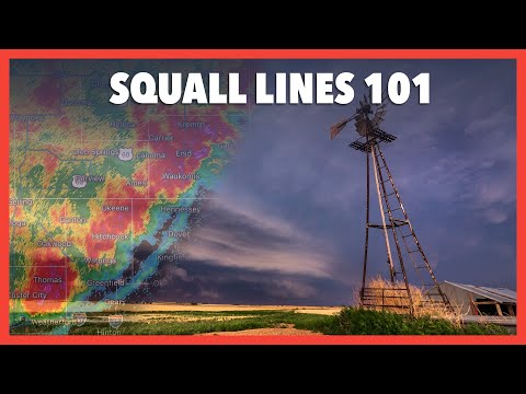
One of the most intriguing phenomena is observed along the leading edge of a squall line. The cloud phenomenon typically found in this area is known as a shelf cloud. This feature often appears as a dense, arch-shaped formation that signals powerful thunderstorms are near.
As storms develop, warm, moist air rises, meeting cooler air at the surface. This interaction creates instability, leading to the formation of a gust front.
The shelf cloud forms when the cooler air pushes the warm air upwards, causing it to cool and condense rapidly. Observing a shelf cloud can be both awe-inspiring and a warning sign of the severe weather that may follow.
As squall lines move forward, the dramatic shift in weather can bring strong winds and heavy rain. Recognizing the signs of these storms ensures better preparedness and safety during unpredictable weather.
Engaging with this topic can deepen appreciation for the complexities of the atmosphere and its impacts on our lives.
Squall Line Dynamics and Structure
Squall lines are complex weather systems that form with a characteristic structure and dynamic behavior. Understanding their characteristics and features, such as shelf clouds and gust fronts, is crucial for forecasting and safety.
Characteristics of a Squall Line
A squall line is a series of thunderstorms that develop along or ahead of a cold front. These storms can produce heavy rain, strong winds, and sometimes even severe weather like tornadoes.
The structure often includes a line of convection, where ordinary cells form and can evolve rapidly. This development is driven by updrafts that lift warm, moist air. When the updrafts weaken, downdrafts follow, leading to gusty winds.
The lifting of warm air increases the convective available potential energy (CAPE), which fuels storm intensity.
Radars typically show squall lines as elongated bands of precipitation. These lines can extend for hundreds of miles and are associated with damaging wind events, making them significant to monitor.
Shelf Cloud and Gust Fronts
A shelf cloud is a distinctive feature often associated with a squall line. It appears as a low-hanging, dark cloud that indicates the presence of a gust front.
The gust front is formed when cool, downdraft air spreads out and lifts warm, moist air ahead of the storm. This interaction can lead to sudden increases in wind speed and direction.
The shelf cloud itself is an indicator of severe weather potential. It signifies that strong winds are imminent and alerts observers to the possibility of tornadoes forming.
As squall lines move through an area, the combination of heavy rain and wind damage can be significant. Understanding these phenomena helps in preparing for potential hazards brought by severe weather conditions.
For more information on wind effects, consult articles that detail the impact of severe weather events like squall lines.
Associated Severe Weather Events

The leading edge of a squall line is often associated with severe weather events, including tornadoes and derechos. Understanding these phenomena helps in predicting their impact on the surrounding areas.
Tornadoes and Supercells
Tornadoes can form from the rotation within supercells, which are powerful thunderstorms characterized by a rotating updraft called a mesocyclone. These supercells are often found near squall lines.
Tornadoes typically produce intense wind damage. They can cause destruction to buildings and uproot trees. The rotation of the storm can lead to the formation of a wall cloud, which is a visible lowering of the cloud base. If the wall cloud tightens, it increases the chances of tornado development.
Severe storms can generate hail, which can also accompany tornadoes. Hail can be quite damaging, adding to the overall impact of the storm systems.
Derechos and Bow Echoes
Derechos are widespread, long-lived wind storms that can occur in conjunction with squall lines. The strong winds associated with these storms can reach speeds over 100 miles per hour, causing significant wind damage.
Bow echoes represent a specific radar signature within a squall line. This feature indicates that the storm is producing an area of enhanced winds.
As winds accelerate along the leading edge, they create a bowing shape on radar images. This phenomenon can generate straight-line winds, contributing to severe damage, similar to that caused by tornadoes.
Both derechos and bow echoes emphasize the importance of monitoring storm systems closely for safety and preparedness.