
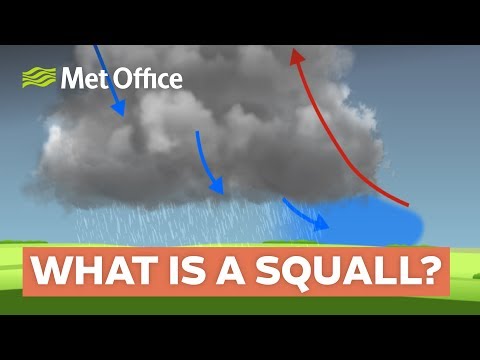
A squall is a significant weather phenomenon characterized by a sudden and sharp increase in wind speed.
These strong winds typically last for several minutes and can be associated with various types of weather, including rain, snow, or thunderstorms.
Squalls can occur quickly, making them dangerous for those caught unprepared.
Understanding what a squall is and how it can impact weather conditions is crucial for safety, especially for outdoor activities or travel.
In meteorology, a squall is defined by its rapid onset and intensity. Winds may increase swiftly, reaching speeds of 18 miles per hour or more, which can create hazardous conditions.
For drivers and outdoor enthusiasts, recognizing the signs of an approaching squall is essential to avoid risks related to sudden changes in weather, such as decreased visibility and slippery surfaces.
The impact of a squall can be felt unexpectedly, and knowledge about these weather events can empower individuals to make safer decisions.
By exploring the characteristics and implications of squalls, readers can better prepare themselves for unpredictable weather patterns.
Characteristics of Squalls
Squalls are sudden, intense weather events that can produce strong winds and heavy precipitation. Understanding their dynamics is crucial for predicting their impact on the environment and safety.
Understanding Wind Gusts and Squall Lines
Wind gusts often accompany squalls, causing rapid increases in wind speed. A squall line is a linear formation of thunderstorms that can create these powerful gusts.
The presence of vertical wind shear, or changes in wind speed and direction with height, plays a significant role in the formation of squall lines.
These wind shifts can lead to dangerous weather, including downbursts and gust fronts. A downburst is a strong downdraft that creates damaging winds at the surface.
Wind damage from squalls can include downed trees and damaged structures, posing risks to people and property. Understanding these wind patterns helps forecasters predict severe weather events effectively.
Weather Events Associated with Squalls
Squalls are linked to various severe weather phenomena, including thunderstorms, hail, and heavy rain. Often, they herald the onset of heavy snow in winter months, leading to conditions that can be hazardous for travel.
Strong instability in the atmosphere can enhance the development of a squall, increasing the likelihood of severe weather.
Bow echoes and mesoscale convective systems (MCS) are common patterns seen in the radar reflectivity of squalls, indicating areas of intense precipitation. When thunderstorms intersect with these systems, they can produce tornadoes and significant lightning, adding to the danger of squall events.
Visual Indicators and Weather Patterns
Visual indicators of squalls include features like shelf clouds, which are horizontal cloud formations that signify oncoming storms. Observing these clouds can provide early warnings of severe weather.
Additionally, radar reflectivity can highlight precipitation types, helping meteorologists identify squall conditions.
As squalls approach, precipitation typically shifts from light rain to heavy rain or snow rapidly.
Understanding these visual cues and patterns is essential for those monitoring weather conditions. Being able to interpret signs of squalls can enhance safety for individuals and communities. For more information on snow and ice related events, refer to articles that explore these topics.
Squall Detection and Safety Measures

Detecting squalls and ensuring safety during these weather events is crucial for minimizing risks. Effective monitoring and forecasting techniques play a vital role, along with specific preventive actions and safety protocols.
Monitoring and Forecasting Techniques
Meteorologists employ various tools to detect squalls. They utilize radar reflectivity to identify intense precipitation and wind speed changes. This helps in spotting squall lines, which often precede severe weather.
Mesoscale convective complexes (MCC) are crucial in tracking squalls, especially those associated with heavy rain and damaging winds.
Doppler radar can reveal downdrafts, indicating the presence of microbursts, which can lead to sudden gusts. Frequent lightning detection systems also help forecast squall risks.
Weather forecasts are available for assessing squall conditions. By analyzing temperature, humidity, and wind patterns, meteorologists can anticipate the development of snow squalls and severe weather conditions. Early warnings are essential for public safety.
Preventive Actions and Safety Protocols
When a squall is detected, immediate actions should be taken to ensure safety.
First, individuals should reduce their speed and keep headlights on during low visibility conditions.
It’s essential to seek shelter, especially during severe wind gusts that can lead to straight-line wind damage.
Travelers should stay informed by listening to weather updates on their local broadcast stations or via mobile apps.
In areas prone to squalls, it’s wise to carry an emergency kit that includes food, water, and necessary medications.
During heavy precipitation, drivers should avoid flooded roads.
If trapped in severe weather, it’s safer to remain inside a vehicle rather than seek shelter under trees, where lightning strikes are common.
Staying calm and informed helps navigate these potentially dangerous situations.