
Meteorologists use radar technology to detect and track severe weather, and one important radar feature is the hook echo.
A hook-shaped echo often indicates the presence of a mesocyclone, which can signal favorable conditions for tornado formation. This distinctive pattern appears as a hook extending from the main storm and is typically found in supercell thunderstorms.
Understanding the significance of a hook echo is crucial for both forecasters and the public.
While not every hook echo results in a tornado, its presence in radar images raises the alert for potential severe weather. This makes it a vital tool for early warnings and helps communities prepare for possible dangerous conditions.
As storms develop, monitoring radar signatures like the hook echo can provide insights into their behavior.
By keeping a close eye on these indicators, meteorologists aim to give timely warnings and reduce the risks associated with tornadoes and severe thunderstorms.
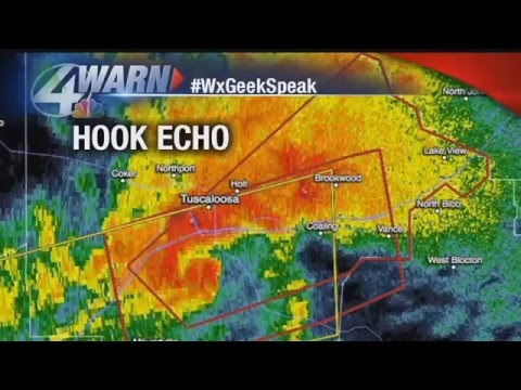
Understanding Hook Echoes and Associated Weather Phenomena

Hook echoes are significant indicators in meteorology that reveal critical information about severe weather, particularly tornadoes. These distinctive radar signatures can help forecasters assess the potential for dangerous conditions and initiate appropriate alerts.
The Hook Echo Formation
A hook echo forms when radar waves reflect off a supercell thunderstorm. This occurs in the lower part of the storm, as airflow and precipitation wrap around a rotating column of air known as a mesocyclone.
The characteristic hook shape indicates strong updrafts that can lead to tornado formation. Rain, hail, or other debris can contribute to the hook echo’s appearance, assisting radar technology in identifying severe weather.
When structured correctly, these echoes showcase a bounded weak echo region (BWER), which signifies intense upward motion. Recognizing these formations is crucial for timely warnings.
Doppler Radar and Tornado Detection
Doppler radar plays a vital role in capturing a hook echo’s movement and intensity. This technology measures the velocity of particles within a storm using the velocity couplet, which helps meteorologists detect rotation.
When tornadoes develop, the radar often shows a distinct couplet where winds are rotating in opposite directions.
Meteorologists rely on this data to issue tornado warnings through the National Weather Service. An accurate interpretation of these signatures can mean the difference between safety and disaster during severe weather events.
Supercell Characteristics
Supercell thunderstorms are the primary producers of hook echoes. These storms have a unique structure that allows for prolonged tornado activity.
Key features of supercells include the rotating mesocyclone, strong updrafts, and a well-defined downdraft.
As a supercell matures, it may evolve into a bow echo or produce damaging straight-line winds—a phenomenon known as a derecho.
These storms are also home to severe weather like heavy rain, large hail, and potent tornadoes. Understanding these characteristics helps in predicting and monitoring severe weather effectively.
Identifying Dangerous Weather Patterns
Recognizing hook echoes is essential in identifying potentially hazardous weather patterns.
When a hook echo appears alongside other indicators—such as debris balls or strong velocity signatures—it raises concerns for severe weather events.
Meteorologists monitor these signals closely to assess the likelihood of tornadic activity.
This information is critical for issuing timely tornado warnings and informing local communities about oncoming dangers. Early detection can save lives and help mitigate damage during severe weather outbreaks. Understanding these patterns enhances forecasting capabilities and improves public safety efforts.
Enhancing Public Safety and Awareness
The ability to detect and understand hook-shaped echoes is crucial for public safety during severe weather events.
Proper education and efficient communication can help communities prepare for possible tornadoes and other dangerous weather phenomena.
Role of the National Weather Service
The National Weather Service (NWS) plays a vital role in monitoring severe weather and issuing tornado warnings.
Using advanced Doppler radar technology, the NWS can detect hook-shaped echoes indicating potential tornado activity.
When such an echo is identified, the NWS promptly notifies local authorities and the public through various channels, including TV, radio, and the internet.
Public education is essential in raising awareness about tornado warnings.
The NWS promotes safety protocols, teaching communities what to do when a warning is issued. Providing clear, actionable steps can save lives. For example, people are urged to seek shelter in basements or interior rooms of sturdy buildings.
Utilizing platforms like Weather.com allows individuals to stay informed about developing weather situations.
Historical Perspectives on Tornado Detection
Historically, tornado detection has evolved significantly. In the early days, reports relied heavily on eyewitness accounts and rudimentary weather observation techniques.
This made it challenging to provide timely warnings. With advancements in technology, such as Doppler radar, meteorologists can now detect storm rotation that leads to tornado formation.
This has improved response times. Donald Staggs from the Illinois State Water Survey emphasizes how these advancements have revolutionized how communities prepare for tornadic activity.
Education and repeated drills have further enhanced public awareness. Communities are better prepared for severe weather than ever before.
As detection methods continue to improve, ongoing public education remains key in ensuring safety during tornado outbreaks.