
Tornadoes are powerful weather events that can cause significant damage. A tornado that doesn’t touch the ground is called a funnel cloud.
This rotating column of air is a sign of severe weather and indicates that a tornado could form if it makes contact with the ground.
Funnel clouds can be fascinating to watch, but they are also a warning to take safety precautions.
Understanding the distinction between a tornado and a funnel cloud is essential for anyone interested in atmospheric phenomena.
A funnel cloud is characterized by its vortex shape, extending from the base of a thunderstorm without reaching the earth. While it may not cause direct damage, it signifies the potential for a tornado to develop, which can lead to dangerous conditions.
For more information on atmospheric events, consider exploring articles about various atmospheric phenomena.
Meteorologists study these weather patterns to better predict severe storms and protect communities.
Being aware of what a funnel cloud is and its implications can help individuals stay alert during stormy weather. Tornado safety starts with knowledge, so recognizing the signs of potential tornado activity is crucial.
Tornado Formation and Characteristics
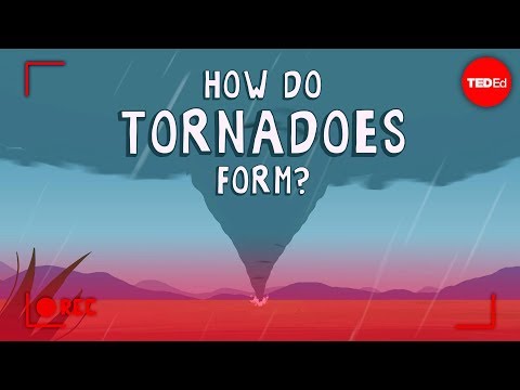
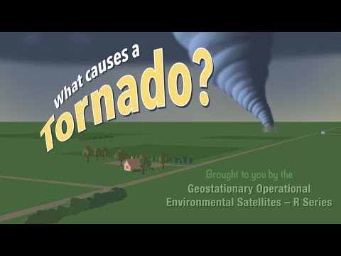
Tornadoes are fascinating atmospheric phenomena that result from specific conditions during thunderstorms. Understanding how they form, their various types, and the role of wind shear is essential for anyone interested in severe weather.
Understanding Tornado Basics
A tornado is a rotating column of air that extends from a thunderstorm to the ground.
Most tornadoes develop from supercell thunderstorms, which are large, organized storms characterized by a rotating updraft called a mesocyclone.
Tornadoes can vary greatly in size and strength. They are classified according to the Enhanced Fujita (EF) Scale, which rates their intensity based on damage caused.
Most tornadoes are short-lived, lasting only a few minutes, while some can remain on the ground for over an hour. Tornadoes that do not touch the ground are known as funnel clouds. A funnel cloud is essentially a tornado that has not made contact with the surface.
Classifying Tornado Types
Tornadoes come in various shapes and sizes. Some common types include landspouts, waterspouts, multiple-vortex tornadoes, wedge tornadoes, cone tornadoes, and rope tornadoes.
- Landspouts form similarly to dust devils and can occur over land without a significant storm.
- Waterspouts form over water and can transition to tornadoes if they move onto land.
- Multiple-vortex tornadoes contain smaller, rotating columns of air around a central vortex.
Each type has its own characteristics, which can impact the level of destruction caused. For example, wedge tornadoes are wider and can cause massive damage, while rope tornadoes tend to be weaker and thin.
Phenomenon of Wind Shear
Wind shear refers to the change in wind speed and direction at different altitudes. This phenomenon is crucial in tornado formation because it creates the rotation needed for a mesocyclone to develop.
As warm, moist air rises, it can interact with cooler, drier air above. If the wind changes direction and speed with height, it enhances rotation within the thunderstorm.
Storm chasers monitor these conditions closely to predict tornado formation.
Understanding wind shear is vital for improving safety measures and forecasting severe weather events. Those interested in more insights on wind can explore articles on wind.
Tornado Detection and Safety
Tornado detection and safety are crucial for minimizing the impact of these dangerous storms. Understanding how to detect tornadoes and the safety measures to take can significantly protect lives and property.
Methods of Tornado Detection
Several methods are used for tornado detection. Meteorologists rely heavily on Doppler radar.
This technology can detect rotation within storm systems. Its ability to identify wind patterns helps in spotting potential tornadoes early.
Another important method involves storm spotters, trained individuals who monitor weather conditions in real-time. They provide valuable reports about storm behavior that technology may miss.
Additionally, mobile Doppler radar units can be deployed to follow storms closely. This allows for immediate data collection and analysis, increasing the speed of warnings.
By combining these methods, forecasters can issue tornado watches and tornado warnings, alerting the public about the threat level.
Safety Measures and Precautions
Tornado safety begins with preparedness. Families should establish a tornado shelter in their homes, ideally a basement or a small interior room with no windows.
When a tornado warning is issued, it’s critical to seek shelter immediately.
Listening to weather updates via radios or weather apps is essential during severe weather.
During a tornado, it’s advised to avoid windows and cover oneself with sturdy furniture or heavy blankets. Staying informed about local tornado season, particularly in areas known as Tornado Alley, can help families plan ahead.
Emergency kits should include essential supplies like water, non-perishable food, and medications. Regular drills can ensure everyone knows how to react quickly.
Enhanced Fujita Scale
The Enhanced Fujita Scale measures tornado intensity based on the damage caused. This scale ranges from EF0 to EF5.
- EF0 indicates light damage, while an EF5 represents devastating destruction, like total destruction of well-built houses.
This scale helps communities understand the potential impact of tornadoes.
It also informs construction practices and emergency response plans.
Knowing this scale aids in raising awareness and preparedness for severe weather events. Ultimately, it saves lives and resources when tornadoes strike.