
Recognizing a supercell can be crucial for anyone interested in severe weather. A supercell is identified by its rotating updraft, known as a mesocyclone, which sets it apart from typical thunderstorms.
These thunderstorms can last for hours and often produce extreme conditions like large hail, damaging winds, and even tornadoes.
To determine if a thunderstorm is a supercell, look for key characteristics such as a visually distinct structure and persistent rotation.
While regular storms may develop quickly and dissipate, supercells maintain a well-organized appearance and have a long lifespan.
Understanding these patterns can help individuals stay safe during severe weather events.
For those fascinated by atmospheric phenomena, understanding supercells is essential. Monitoring the weather and recognizing the signs of these dangerous storms can make a significant difference in safety and preparedness.
In fact, learning about these unique storms adds to the appreciation of the complex forces at play in our atmosphere, as seen in various articles on related topics.
Identifying Characteristics of Supercells
Knowing how to identify supercells is essential for recognizing severe weather. Supercells are distinct from other thunderstorm types due to their unique features, including a rotating updraft and specific cloud formations.
These characteristics help in anticipating the storms’ potential.
Defining the Supercell
A supercell is a highly organized thunderstorm known for its deep, rotating updraft called a mesocyclone. Unlike regular thunderstorms, supercells can persist for several hours and often produce severe weather phenomena, including tornadoes and large hail.
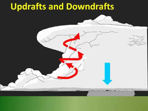
The structure of a supercell allows it to continuously draw warm, moist air, helping sustain its strength. They typically form in environments with significant wind shear, which is the change in wind speed and direction with height. This dynamic environment supports the development of their unique rotating features.
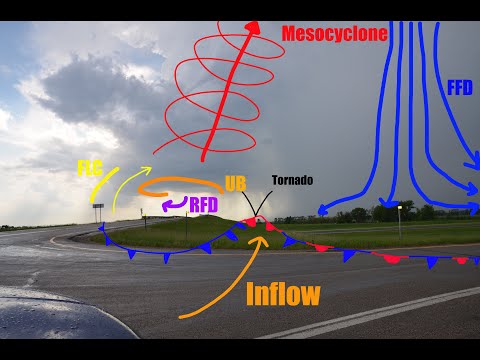
Rotating Updraft: The Mesocyclone
The mesocyclone is the heart of a supercell and represents its rotating updraft. This feature distinguishes supercells from other types of thunderstorms.
A mesocyclone forms when wind patterns create a horizontal vortex that is tilted vertically by the storm’s updraft. When a mesocyclone strengthens, it can lead to severe weather events, including tornadoes.
Observing signs of a mesocyclone is critical; it often presents as a wall cloud beneath the storm. Conditions around the mesocyclone are turbulent, producing intense winds, hail, and frequent lightning, which are common in severe weather scenarios.
Typical Supercell Features
Supercells have several hallmark features that make them recognizable. One such feature is the rain-free base, which is the area immediately under the updraft where precipitation is minimal. This zone often becomes a vantage point for storm spotters.
Additionally, supercells typically showcase a flanking line, a series of cloud formations that extend outward from the main storm, signaling that severe weather may be imminent.
Hail can also form in supercells due to strong updrafts that carry moisture high into the atmosphere and cool it rapidly. These key features help spotters and meteorologists forecast potential severe weather events.
Differentiating Supercells from Other Thunderstorm Types
Recognizing a supercell involves distinguishing its characteristics from those of regular thunderstorms. Ordinary thunderstorms lack the organized structure and longevity of supercells.
While many storms may produce lightning and rain, supercells are noted for their ability to produce organized rotation and severe weather outcomes, such as tornadoes.
Features like the distinct rain-free base and the presence of a wall cloud under the updraft are not typically observed in simpler storm types. Understanding these differences is critical for anyone involved in storm tracking or safety preparations.
Spotting a supercell early can be vital for public safety during times of severe weather events, including when strong winds or heavy rains are anticipated.
Warning Signs and Safety Measures
Recognizing the signs of a supercell can help individuals and communities take essential safety measures. Awareness of the potential hazards and preparation for severe weather can save lives and reduce damage.
Recognizing Impending Supercell Hazards
Supercells are unique among thunderstorms as they often produce severe weather events such as tornadoes, large hail, and damaging winds. Key indicators include an increase in atmospheric instability and the presence of rotating storm clouds.
Look for features such as a well-defined wall cloud, which indicates that a tornado may form. Other signs include heavy rain falling alongside strong outflow winds.
Before a storm develops, weather radar from sources like the National Weather Service can provide valuable information about storm prediction and potential hazards. Awareness of these signs enables timely alerts.
Safety Protocols During Supercell Events
During a supercell event, safety is a priority. Individuals should seek shelter, ideally in a building or basement, away from windows.
If there is a tornado warning, staying low and covering oneself can provide protection from flying debris.
It is essential to remain tuned to local weather updates via a radio or smartphone app for real-time alerts.
Heavy rain can lead to flash flooding, so avoid walking or driving through floodwater. Additionally, large hail can cause injury.
Indoor activities, away from windows, are crucial for safety during severe thunderstorms.
Community and Personal Preparedness
Communities should have a plan for severe weather events. Local storm spotters and trained volunteers can assist in alerting the populace.
Educational campaigns can teach individuals how to recognize the conditions that lead to supercells.
Personal preparedness includes having an emergency kit with essentials such as water, non-perishable food, and a flashlight.
Families should have a communication plan in place to connect during an emergency. Keeping informed about local weather conditions ensures readiness and enhances safety when severe weather strikes.
Training opportunities for residents can help them respond effectively when storms occur.