
Supercells are among the most powerful thunderstorms, capable of producing severe weather events like tornadoes and heavy precipitation. These storms can last for several hours, often exceeding one hour. In some cases, they endure for many hours or even longer.
Their unique structure, characterized by a rotating updraft known as a mesocyclone, allows them to maintain their strength and intensity, which can lead to significant weather impacts over large areas.
The formation and longevity of supercells depend on environmental conditions, including moisture and wind patterns. When these elements align favorably, supercells can develop into highly organized storm systems.
These systems are notorious for spawning destructive tornadoes that can travel long distances, as well as causing intense rainfall and flash flooding. For those interested in understanding the complexities of atmospheric phenomena, supercells provide a fascinating subject of study.
Monitoring these storms is crucial for predicting severe weather. Meteorologists rely on various tools and data to analyze supercell behavior and anticipate potential impacts.
For more insights into atmospheric phenomena, check out articles that explore the dynamics at play in these extreme weather events.
Supercell Characteristics and Dynamics
Supercells are unique types of thunderstorms that can produce severe weather. They have specific characteristics and dynamics that define their development and lifecycle.
Key features include their rotating updrafts and the potential for long lifespans.
Formation of Supercells
Supercells begin to form under conditions of strong vertical wind shear. This wind shear creates different speeds and directions of wind at varying altitudes, which helps to organize the storm.
The process starts with an isolated thunderstorm, often referred to as a classic supercell.
As warm, moist air rises, it creates an updraft. This updraft can become strong enough to rotate, forming a mesocyclone. The v-notch appearance is common in radar images of supercells, marking the point where the updraft helps to organize the storm structure.
Flanking lines may develop as new storms form alongside the main updraft, feeding it. This process fuels the storm, allowing it to maintain strength and longevity.
Lifecycle of a Supercell
The lifecycle of a supercell typically consists of three stages: the developing stage, the mature stage, and the dissipating stage.
During the developing stage, a rotating updraft forms, fueled by warm air. This stage can last around 30 minutes, setting the stage for severe weather.
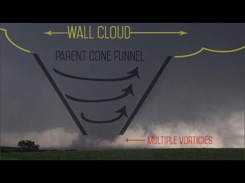
In the mature stage, the supercell reaches its peak intensity. Here, both an updraft and a downdraft are present, leading to significant precipitation and potential tornado formation. Wall clouds may also develop, indicating the possibility of tornadoes.
As the storm moves into the dissipating stage, the updraft weakens, and precipitation decreases. The storm can still produce severe weather, but it gradually loses its structure and energy.
Supercell Classification
Supercells are classified into three main types: classic, high precipitation (HP), and low precipitation (LP) supercells.
-
Classic Supercells are characterized by well-defined structures with rotating updrafts.
-
HP Supercells produce heavy rain and often obscure the tornado, making them difficult to spot.
-
LP Supercells have weaker updrafts, produce less rain, and are associated with larger hail.
Understanding these classifications helps meteorologists predict the potential for severe weather, including tornadoes. For those interested in extreme weather, the study of supercells is crucial, as they are among the most dangerous storm systems. More detail on these storms can be found in resources about electrical storms.
Supercell Impact and Weather Phenomena

Supercells have a significant impact on weather events. They produce some of the most severe thunderstorms, leading to various dangerous weather phenomena. Understanding these impacts helps in preparing for and responding to potential disasters.
Severe Weather Events
Supercells are known for creating extreme weather conditions. These storms can produce large hail, with stones that can exceed 2 inches in diameter. They can also generate damaging winds exceeding 70 mph, which can cause extensive property damage.
A key feature of supercells is their potential to spawn tornadoes. The tornado climatology indicates that supercells are responsible for most of the strong tornadoes in Tornado Alley. The powerful updrafts create conditions that lead to the formation of a hook echo on Doppler radar, signaling the presence of a possible tornado.
Severe thunderstorms associated with supercells often also lead to squall lines, which can stretch for miles, delivering gust fronts and outflow boundaries that create additional storms in the vicinity. These phenomena can linger for several hours, threatening communities in their path.
Predicting and Tracking Supercells
Forecasters use advanced weather radar technology to track supercells. Doppler radar provides crucial data on storm rotation and intensity. This helps in the issuance of timely tornado warnings, alerting communities ahead of time.
Meteorologists look for specific signatures in radar data, such as the hook echo that indicates a rotating storm. These tools are essential for predicting the storm’s path and potential impacts.
Public awareness is critical during active severe weather. Accurate storm tracking can reduce fatalities by providing early alerts. The use of social media and weather apps helps disseminate information quickly, making resources more accessible to the public.
Safety Measures and Preparation
Preparation is vital when facing the threat of supercells.
Communities in risk areas should develop tornado safety plans, which include designated safe places to shelter during storms. Ensuring everyone knows where to go can save lives.
Residents should stay informed about weather updates.
Tracking tornado season is important for understanding when to be most vigilant. Keeping emergency kits ready and having a communication plan can make a significant difference during severe weather events.
Engaging the community in safety drills can also enhance readiness.
Communities that practice emergency responses are often better prepared when real events occur. Awareness of strong winds and their potential for damage is essential for minimizing risks during supercell activity.