
Lava cooling is a fascinating process that can take much longer than most people expect. It can take just 10 to 15 minutes for a thin crust to form on the surface, but the interior can take several months or even years to cool completely.
Factors such as the thickness of the lava flow and the ambient temperature play significant roles in how quickly it cools.
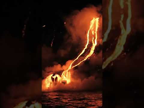
When considering the Kīlauea Volcano, a well-known site for lava flows, studies show that thick flows can remain hot for extended periods.
The cooling rate slows down significantly due to the insulating properties of the surface crust, which keeps heat trapped inside.
The Science of Lava Cooling

Lava cooling involves several factors, including temperature and flow characteristics. Understanding these elements helps grasp how long it takes for lava to solidify after an eruption.
Understanding Lava Temperatures and Cooling Rates
Eruptive lava temperatures typically range from 700 to 1,200 degrees Celsius (about 1,292 to 2,192 degrees Fahrenheit).
The initial cooling occurs quickly, forming a thin crust that insulates the hot interior. This insulation slows further cooling.
For example, basaltic lava flows, like pāhoehoe, can develop a surface crust in just 10-15 minutes. However, it may take several months for the core to reach lower temperatures.
In cases of thicker flows, like a‘ā, solidification can take significantly longer due to their greater mass and heat retention.
Calculating cooling rates depends on various factors, including flow thickness and the lava’s thermal properties. Cooling rate calculations suggest that a layer around 1 meter thick could form in approximately 24 hours under consistent cooling conditions.
Influences on Lava Cooling Times
Several factors influence how long lava remains hot. Flow thickness plays a crucial role; thicker flows take longer to cool than thinner ones.
For instance, a 4.5-meter flow may take more than 130 days to cool down to about 200 degrees Celsius (or 290 degrees Fahrenheit).
Heat loss also varies depending on environmental conditions. Lava lakes, for example, lose heat more slowly than solidified flows due to their liquid nature, allowing heat to escape evenly.
Additionally, surface cooling is affected by the ambient temperature and wind conditions. As the lava cools, the rate of heat loss declines, meaning the cooling process slows over time, leading to extended solidification times.
Volcanic Landscapes and Lava Eruptions
Volcanic landscapes are shaped by various eruptions, each influencing the surrounding terrain. Understanding these flows is vital for assessing volcanic activity and potential hazards.
Studying specific events like the Kīlauea eruptions provides key insights into the monitoring and measurement techniques used by scientists.
Case Studies: Kīlauea and Historical Lava Flows
The Kīlauea Iki eruption in 1959 was a notable event characterized by explosive activities and lava fountains. It significantly altered the landscape, creating new formations.
More recently, the 2018 Lower East Rift Zone (LERZ) eruption, particularly Fissure 8, showcased the power of volcanic forces. This eruption released large lava volumes, impacting areas like Kalapana.
The Kīlauea caldera is a central feature that can indicate ongoing volcanic activity. Observations from the U.S. Geological Survey and Hawaiian Volcano Observatory reveal patterns in seismicity and ground deformation. These measurements help predict potential eruptions and hazardous conditions.
Observing Lava: Monitoring and Measuring Techniques
Monitoring volcanic activity is crucial. Techniques include measuring gas release and monitoring ground deformation, which can indicate magma movement.
The Hawaiian Volcano Observatory employs various tools to gather real-time data. For instance, sensors detect steam rising from fissures and identify areas of incandescently hot lava.
By analyzing this data, scientists can better assess the magma reservoir’s behavior. Real-time observations help in predicting lava flow paths and understanding risks to nearby communities, such as Kalapana.
Regular assessments allow for effective emergency responses, ensuring public safety in volcanic environments. Implementing tools for tracking surface movement is important for long-term monitoring of these dynamic landscapes.