Tornadoes are one of nature’s most powerful storms, and understanding their origins can be crucial for safety.
The type of cloud that starts a tornado is typically a thunderstorm cloud known as a supercell.
Within these powerful storms, specific conditions lead to the formation of tornadoes, including warm, moist air rising through cooler, denser air.
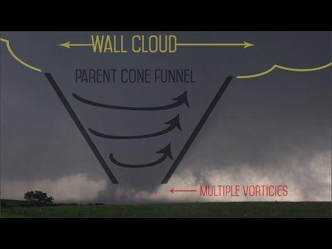
As a thunderstorm develops, it creates rotating columns of air that can eventually drop down to form a tornado. The presence of strong updrafts and a well-defined wall cloud indicates the potential for tornado formation.
Recognizing these weather patterns can help people stay alert during severe weather conditions.
The Anatomy of Thunderstorms and Tornadoes

Thunderstorms and tornadoes are complex systems influenced by various atmospheric factors.
Understanding the specific types of clouds involved, the roles of wind and temperature, and methods to assess tornado intensity is essential in grasping how tornadoes form.
Cumulonimbus Clouds and Tornado Development
Cumulonimbus clouds are integral to tornado formation.
These towering clouds develop in unstable air where warm, moist air rises rapidly. As this air ascends, it cools, leading to condensation and the formation of a thunderstorm.
Within these clouds, a stronger updraft can create a rotating column of air known as a mesocyclone. If conditions remain favorable, this rotation intensifies, potentially leading to the development of a tornado.
The funnel cloud descends from the base of the cumulonimbus. If it touches the ground, it is then classified as a tornado. Supercells, a type of thunderstorm, are particularly notorious for producing severe tornadoes due to their organized structure and long-lived nature.
The Role of Wind Shear and Temperature
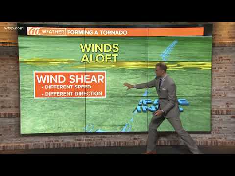
Wind shear refers to the change in wind speed and direction at different heights. When wind shear is strong, it can create a horizontal spinning effect in the atmosphere.
If warm air at the surface rises and meets cooler air aloft, this can tilt the rotating air into a vertical orientation. This process is essential for tornado initiation.
Temperature differences play a crucial role as well. Warm, moist air provides the necessary fuel for thunderstorms, while cold air aloft helps create instability. This combination can produce severe thunderstorms capable of spawning tornadoes, especially when significant vertical wind shear is present.
Assessing Tornado Intensity: Fujita Scales
To gauge tornado intensity, meteorologists use the Fujita Scale, which ranks tornadoes from F0 to F5 based on the damage they cause and wind speed.
An F0 tornado has wind speeds of 40-72 mph, while an F5 can exceed 200 mph, causing catastrophic destruction.
The Enhanced Fujita Scale (EF Scale) refines this assessment, providing more detail on the types of structures affected. For example, wedge tornadoes, which are wide and extremely powerful, often classify as EF4 or EF5.
Multiple-vortex tornadoes display smaller swirling columns of air within a larger tornado and can cause varied damage across their path.
Understanding these scales helps predict the potential damage and improve safety measures during tornado events.
Monitoring and Predicting Tornado Occurrences

Monitoring and predicting tornado occurrences involves a combination of advanced technology and keen observation.
Meteorologists use various tools and techniques to track storms and issue timely alerts. Understanding how tornadoes develop and the conditions that lead to their formation is crucial for effective forecasting.
Tornado Watches and Warnings
Tornado watches and warnings are vital in keeping communities safe. A tornado watch indicates that conditions are favorable for tornadoes to form, while a tornado warning means a tornado has been spotted or indicated by radar.
Meteorologists often rely on Doppler radar, which detects wind patterns and helps identify rotating storms.
During severe storms featuring heavy rainfall, hail, and lightning, the risk of tornado formation increases. Timely notifications allow communities to take shelter and prepare for potential impacts.
Staying informed through local news or weather apps is essential for safety during these events.
Supercells and Tornado Alleys
Supercell thunderstorms are the primary producers of tornadoes. These storms have a rotating updraft called a mesocyclone, which can lead to tornado development when conditions are right.
Tornado Alley, a region in the central United States, is particularly prone to these storms due to its unique geography and climate.
In Tornado Alley, warm moist air from the Gulf of Mexico meets cold dry air from Canada. This clash creates an environment ideal for supercells to form. Understanding this interaction helps forecasters predict when and where tornadoes might occur.
The Role of Storm Spotters and Researchers
Storm spotters play a crucial role in tornado monitoring. These individuals, often volunteers, observe storm conditions and provide real-time reports to meteorologists.
Their observations can include confirming tornado sightings and measuring rear flank downdrafts. These measurements are critical in understanding storm behavior.
Researchers study tornadoes to improve prediction models. This research includes analyzing past tornado events and the data collected by storm chasers who follow severe storms closely.
This fieldwork helps scientists develop better forecasting tools to enhance safety measures for at-risk communities. The collaboration between storm spotters and researchers significantly improves tornado prediction efforts.

