
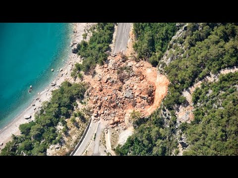
Landslides and mudslides are fascinating yet destructive natural events that often leave a significant impact on the landscape. Geologists refer to landslides as “slope movements,” which include various types such as rock falls and debris flows.
Mudslides, a specific form of landslide, occur when water saturates the soil, causing it to flow downhill with ease. Understanding these terms is crucial for better comprehending the risk factors and behaviors associated with these powerful geological phenomena.

Both landslides and mudslides can pose serious threats to communities, particularly in areas with steep slopes or heavy rainfall. These movements can happen suddenly, driven by factors like rainfall, earthquakes, or volcanic activity.
Familiarizing oneself with the different types of slope movements allows for better preparedness and awareness of their potential dangers.
The study of these events not only helps in assessing risks, but also contributes to developing mitigation strategies. By exploring the terminology and mechanisms behind landslides and mudslides, one gains insight into the essential work of geologists and the importance of safeguarding lives and property from these natural hazards.
Nature and Mechanisms of Landslides
Landslides involve the movement of rock, soil, and debris down slopes due to various factors. Understanding the types and causes of these movements helps recognize the risks associated with landslide hazards.
Types and Classification
Landslides can be categorized into several types based on their movement style and the materials involved. Key classifications include:
- Falls: Rapid downward movement of rock or debris. These often occur on steep slopes.
- Slides: Failures along a distinct surface, where rock or soil slips down.
- Flows: Mixtures of water, soil, and sediment that behave like a fluid. Mudflows and lahars are examples.
- Topples: Forward rotation of a mass of rock or debris.
- Creep: Slow, gradual movement of soil down a slope.
Each type presents unique risks, especially in areas with steep terrains and unstable earth materials. Factors like gravity and moisture can significantly influence these movements.
Causes and Triggers
Landslide movements are triggered by a combination of natural and human-induced factors. Heavy rainfall can saturate soil, leading to increased downslope movement.
Snowmelt and rapid erosion also contribute to slope failures. Seismic activity, such as earthquakes, can destabilize slopes, while volcanic activity may trigger landslides related to eruptions.
Additionally, human actions—like construction and deforestation—can increase landslide risks by altering natural landforms.
Landslide hazards can be worsened by wildfires, which remove vegetation and reduce soil’s ability to hold water. Experts emphasize the importance of understanding these mechanisms to mitigate potential dangers effectively. More information on these dynamics can be found in the articles on surface movement.
Landslide Impact and Management
Landslides can cause significant damage to the environment and infrastructure, leading to economic consequences. Effective management involves predicting these events and implementing strategies to minimize risks and impacts on communities.
Prediction and Hazard Assessment
Predicting landslides involves assessing slope stability and identifying areas prone to failures. Experts utilize data from the United States Geological Survey (USGS) to evaluate geological and hydrological factors. Key indicators include steep slopes, soil composition, and rainfall intensity.
A comprehensive risk assessment focuses on community awareness of potential hazards. This includes educating residents about landslide preparedness, such as evacuation routes and emergency plans. Identifying instability points on slopes helps prioritize areas for monitoring and intervention.
Regular monitoring efforts can include remote sensing techniques to track changes in land use and natural conditions that may increase landslide risks. By understanding the triggers of debris flow and other landslide types, authorities can better prepare for property damage and ecological disruptions.
Mitigation Strategies
Mitigation strategies for landslides range from drainage control to erosion control methods.
Proper drainage systems help manage water runoff, which reduces soil saturation and instability.
Additionally, slope reinforcement techniques can stabilize at-risk areas, using materials like retaining walls or soil nails.
Community involvement is essential in implementing these strategies.
Local governments can encourage community awareness through outreach programs, emphasizing the importance of infrastructure protection.
Understanding the economic consequences of landslides is crucial.
Heavy investments in prevention can save communities from higher future costs associated with damage and recovery.
Implementing effective mitigation can reduce losses and enhance overall safety for the affected areas, fostering a resilient environment against landslide hazards.