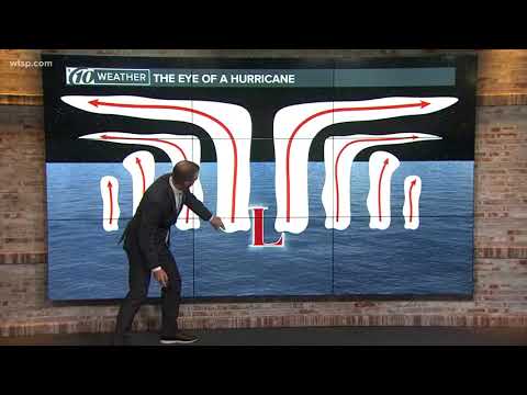
Normal storms do not have an eye like hurricanes or tropical cyclones. The eye is a unique feature of these stronger storms, characterized by calm winds and clear skies at the center, standing in stark contrast to the violent weather surrounding it.
Unlike typical storms that may bring rain and wind without such distinct structures, hurricanes develop eyes as they intensify and organize their wind speeds.
Tropical cyclones, including hurricanes, form under specific conditions. They require warm ocean waters and favorable atmospheric conditions.
As these systems develop, they create the eye, which can lead to hazardous weather conditions outside its calm center. The powerful winds found in hurricanes are responsible for much of the destruction, while the eye offers a temporary respite from the chaos.
Understanding the differences in storm structure is crucial for safety and preparedness.
Knowing that normal storms lack an eye can help individuals take appropriate precautions and recognize when a storm is becoming more dangerous.
Anatomy of a Storm

Understanding the components of storms is essential in recognizing how they function.
The most notable feature of strong storms, like hurricanes, is the eye. However, other factors also play a critical role in storm dynamics, including wind mechanics and internal forces.
Defining the Eye and Eyewall
The eye of a storm is a calm area at the center, often defined by a circular shape. It can vary in size from a few miles to more than 30 miles across.
Surrounding the eye is the eyewall, a ring of powerful thunderstorms. Here, maximum sustained wind speeds reach their peak. The eye wall is where the most damaging winds and heavy rainfall occur, significantly affecting nearby areas.
In many storms, such as hurricanes and cyclones, the structure and symmetry of the eye influence their strength. A storm may feature a specific type known as a pinhole eye, which is smaller and can form as the storm intensifies.
The stability and behavior of these features are essential for forecasting and understanding storm impacts. The calmness of the eye contrasts sharply with the chaotic weather in the eyewall.
Storm System Mechanics
The operations of storm systems involve complex interactions between fluid mechanics and atmospheric conditions.
As warm air rises, it creates low pressure at the surface, drawing in surrounding air. This process, combined with the Coriolis force, contributes to the storm’s rotation.
In the northern hemisphere, storms rotate counterclockwise due to this effect. The opposite occurs in the southern hemisphere.
For storms like Hurricane Ioke, strong upward motions and latent heat release from condensation amplify their energy. This results in higher wind speeds and more intense rainfall.
Understanding these mechanics helps experts predict storm paths and potential hazards.
The Role of Wind Speed and Direction
Wind speed is crucial in determining the strength and behavior of storms. As wind speeds increase, the rotation and intensity of the storm also rise.
Maximum sustained wind speeds of over 74 mph categorize storms as hurricanes.
Internal friction within the storm can affect wind patterns. As air moves, it experiences changes in centrifugal force, which influences the distribution of winds.
Wind direction plays a role in storm formation and intensity. Changes from atmospheric conditions can lead to variations in the cyclonic structure, altering its power and path.
For more in-depth exploration of wind patterns, visit articles on wind dynamics.
Effects and Observations of Storm Eyes

Storm eyes represent unique phenomena in severe weather, particularly in cyclones like hurricanes and typhoons. The attributes of storm eyes can provide insights into their impacts and interactions with the environment, as well as how they are monitored for predictions.
Comparative Analysis of Storm Types
Storm types vary significantly in their structure and behavior. Tropical storms, hurricanes, and typhoons often feature an eye, which is the calmest part of the storm.
Unlike normal thunderstorms or tornadoes, which lack a defined eye, these cyclones have clear blue skies in the center.
For instance, Hurricane Wilma illustrated how even powerful storms can have a small yet distinct eye. Its sheltered area with reduced winds may seem deceptive, offering brief respite before severe rainbands return.
Monitoring these systems with satellite imagery helps meteorologists assess storm formation and intensity.
Experience and Impact on the Environment
The eye of a storm has a significant effect on nearby environments. As the storm approaches, the sinking air in the eye leads to calm conditions.
However, this tranquility can quickly give way to destruction, as the surrounding eyewall unleashes heavy rain and strong winds.
Shelters become critical for safety, as those caught in the eye may mistakenly venture outside during the calm period, unaware of the imminent dangers.
The contrast between calmness and chaos is stark, showcasing nature’s unpredictable behavior.
Monitoring and Forecasting Techniques
Meteorologists use various techniques to monitor and forecast storms. Agencies like NOAA and the National Weather Service provide essential data through their advanced systems.
HURSAT and satellite imagery are vital tools that track the development of storm eyes. These technologies help in predicting storm paths, intensity, and duration.
Accurate forecasting is crucial for issuing warnings and ensuring public safety, especially in densely populated regions vulnerable to severe weather events. Understanding the behavior of storm eyes is an essential aspect of effective meteorological practices.

