
The polar vortex plays a significant role in winter weather patterns across the northern hemisphere. It is a large area of cold air surrounding the poles that can shift and influence weather conditions far from the Arctic.
When the polar vortex weakens, it often leads to an influx of cold Arctic air, which can result in heavier snowfall in regions like the United States and Canada.
As winter approaches, many wonder if these cold air outbreaks from a disturbed polar vortex mean increased snow. While not every instance leads to significant snow, the connection between a weakened polar vortex and winter storms is noteworthy. Extreme weather events have been on the rise, partly due to climate change, further complicating predictions about snow levels.
Understanding the polar vortex is essential for grasping the factors that influence winter conditions. It not only shapes the temperature profiles across many areas but can also lead to the kind of severe winter weather that catches people off guard.
As the science of meteorology evolves, the relationship between the polar vortex and snowfall continues to be a topic of great interest.
Polar Vortex and Its Mechanisms
The polar vortex is a complex atmospheric phenomenon that plays a crucial role in influencing winter weather patterns. Understanding its mechanisms helps clarify how Arctic air interacts with other atmospheric elements, particularly the jet stream.
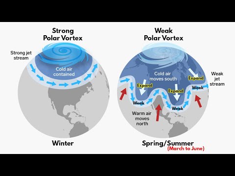
Understanding the Polar Vortex
The polar vortex consists of a large area of low pressure and cold air surrounding the Earth’s poles. It is always present, but its intensity varies by season.
In winter, the polar vortex strengthens, creating colder air masses. This colder air can spill southward, leading to extremely low temperatures in regions far from the poles.
The vortex can change shape and position, sometimes becoming more elongated or splitting into smaller vortices. This variability can significantly affect local weather, especially when cold Arctic air moves into lower latitudes.
The Role of the Jet Stream in Weather Patterns
The jet stream is a fast-flowing air current at high altitudes that influences weather patterns. It often acts as a boundary between cold Arctic air and warmer air from the south.
When the polar vortex is strong, the jet stream tends to stay stable and confined, keeping colder air in the polar regions. If the polar vortex weakens, the jet stream can become wavy, allowing Arctic air to flow south. This can lead to severe winter weather, including heavy snow and extreme cold.
Thus, the jet stream’s behavior is essential for understanding how the polar vortex impacts weather conditions.
Stratospheric Influences on the Polar Vortex
The stratosphere, which lies above the troposphere, is key to the dynamics of the polar vortex. Sudden stratospheric warming events can disrupt the polar vortex, causing it to weaken or split.
During these events, temperatures in the stratosphere rise quickly, altering the movement of Arctic air. This disruption can lead to significant changes in weather patterns at the Earth’s surface.
For example, when the polar vortex is disturbed, cold Arctic air can push further south than usual, leading to increased snowfall and frigid temperatures across various regions.
Understanding these stratospheric influences helps explain seasonal climate variations.
Snowfall, Climate Change, and the Polar Vortex

The polar vortex plays a significant role in winter weather patterns, influencing snowfall amounts and distribution. Climate change, particularly Arctic warming and sea ice loss, further complicates these patterns. Understanding these connections helps clarify how snow events may be affected in a warming world.
Impact of the Polar Vortex on Snowfall
The polar vortex is a large area of low pressure and cold air surrounding the poles. When this vortex weakens, cold air can escape and move southward, bringing frigid temperatures to mid-latitudes. This often leads to increased snowfall in regions that would typically see less.
When a weak polar vortex allows for cold air outbreaks, snowfall can be heavy. This snow typically occurs during specific weather events, such as winter storms. A strong polar vortex, on the other hand, can keep cold air trapped in the Arctic, leading to less snowfall in the southern areas.
Thus, the strength of the polar vortex directly affects how much snow falls in various locations.
Arctic Oscillation and Regional Climate Effects
The Arctic Oscillation (AO) is a climate pattern that affects weather in the Northern Hemisphere. During a positive phase of the AO, the polar vortex is strong, keeping cold air confined to the Arctic regions. This usually means milder winters and less snowfall for the eastern United States.
Conversely, during a negative phase, the polar vortex weakens. This allows cold air to plunge south, often causing severe winter weather and increased snowfall.
The interplay between the polar vortex and the AO can shape winter precipitation patterns, making it essential for meteorologists to monitor these changes closely. These climate patterns can also interact with phenomena like the North Atlantic Oscillation, shaping regional snowfall.
Long-Term Climate Trends and Snow Patterns
Climate change conditions, such as Arctic amplification, are leading to significant shifts in snow patterns.
Warmer temperatures in the Arctic reduce sea ice cover, further altering weather systems.
A warming Arctic contributes to erratic polar vortex behavior, which can increase the frequency of extreme snowfall events.
Long-term trends show that while some areas may experience heavier snowfall due to these changes, others will see a decrease.
The relationship between global warming and snowfall is complex and varies by region.
Monitoring these shifts is critical for understanding future weather predictions and ensuring preparedness for significant snowfall events.
For more information on this topic, explore articles related to snow and ice.