Supercells are a fascinating type of thunderstorm known for their powerful structures and extreme weather events. They can reach impressive sizes and often lead to severe weather phenomena, including large hail and tornadoes.
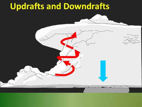
Supercells can grow to be 20 miles wide or more, with updrafts that can extend into the stratosphere, creating conditions for severe storms. As these storms develop, their unique features allow them to persist longer than ordinary thunderstorms, making them a focus of study for meteorologists.
The formation of a supercell involves strong wind shear and an organized updraft, creating a rotating column of air. This rotation can lead to dangerous tornadoes, which are often associated with these massive storms.
Supercells are not only significant because of their size but also due to the intensity of the weather they produce. Hailstones from supercells can exceed golf ball size, causing substantial damage.
For those interested in the science behind these atmospheric phenomena, supercells present a compelling topic. The ability of a supercell to sustain itself and produce damaging weather is why they are crucial to understand for safety and forecasting.
Readers can dive deeper into atmospheric phenomena to explore the complex interactions that lead to the formation of these incredible storms.
Supercell Characteristics and Dimensions

Supercells are unique and complex storm systems with specific characteristics that define their size and scale. Understanding these elements helps in predicting their behavior and the potential severe weather they may produce.
Size and Scale
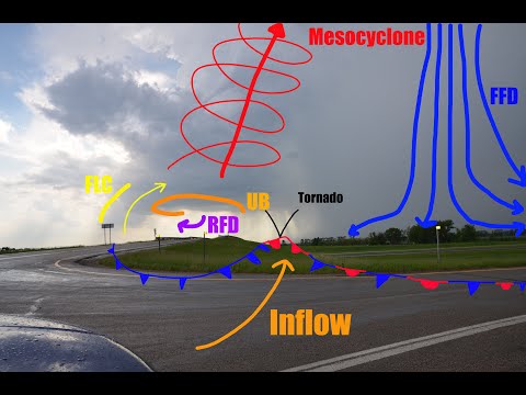
Supercells can be massive, typically spanning 20 to 50 kilometers (12 to 31 miles) in diameter. They feature a rotating updraft known as a mesocyclone, which is vital for their development.
Supercells often maintain their structure for several hours, leading to long-lived supercells that can generate severe weather.
Hail produced by supercells can vary greatly in size, with some stones reaching larger than grapefruit. The updraft speeds in supercells may exceed 40 meters per second (130 feet per second), allowing large hail to be suspended within the storm.
These torrential systems also create an extensive anvil cloud that can stretch several kilometers into the stratosphere.
Atmospheric Conditions for Supercell Development
Several atmospheric factors contribute to supercell formation. Wind shear, which refers to the change in wind speed and direction with height, is crucial for creating rotating updrafts.
Strong wind shear helps to tilt the vertical axis of the storm, giving it the rotation necessary for supercell development.
A capping inversion can also play an essential role by trapping warm air near the surface. This can lead to instability as the air rises, forming towering cumulonimbus clouds.
When these conditions align, they can result in severe weather, including damaging winds and tornadoes. Understanding storm-relative wind patterns is important for predicting the movement and severity of supercells.
For more information on how wind affects weather patterns, check out articles on wind.
Impacts and Manifestations of Supercells

Supercells are known for producing some of the most severe weather events. Their unique structure leads to extreme conditions such as hail, tornadoes, and heavy rainfall. Understanding their impacts and how they are observed is essential for predicting severe weather.
Severe Weather Events
Supercells can generate significant weather phenomena. The presence of wall clouds often signals the potential for severe storms. These clouds can develop into tornadoes, particularly violent ones that can cause vast destruction.
Large hailstones are another manifestation of supercells, frequently resulting in damage to vehicles and crops.
High precipitation supercells may also lead to flash flooding due to intense rainfall over a short period. In some cases, damaging winds accompany supercells, producing downbursts that can reach dangerous speeds.
Outflow boundaries from these storms may enhance development and lead to squall lines, which are groups of storms that can extend for hundreds of miles. Radar features such as a hook echo are critical for identifying these dangerous systems early.
Radar and Observation
Meteorologists rely on advanced radar technology to track supercells. Radar reflectivity helps them visualize storm intensity, while features like the bounded weak echo region provide insights into rotation and potential tornado development.
The rear flank downdraft is another crucial element, playing a role in storm structure and tornado formation. Bow echoes can indicate strong straight-line winds associated with supercells.
By analyzing these radar features, forecasters can warn communities about impending dangers like damaging winds or tornadoes.
For further insights on electrical storms, readers can explore more about Electrical Storms. With this knowledge, detection and preparation can improve, potentially saving lives and reducing property damage.
