
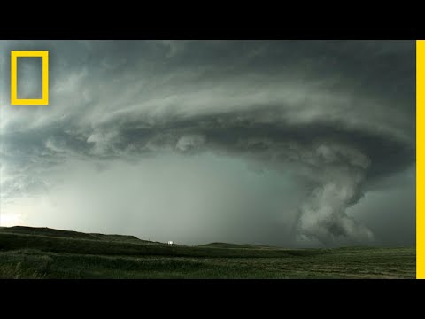
Squall lines are bands of thunderstorms that can produce severe weather. These lines form along or ahead of cold fronts and can move quickly, bringing heavy rain, strong winds, and even tornadoes.
Understanding how squall lines work is crucial for anyone interested in predicting and preparing for severe weather events.
Often, squall lines develop in the late afternoon or evening when environmental conditions are optimal. As warm, moist air rises, it creates an area of low pressure, leading to the formation of thunderstorms.
This process of convective activity can lead to dangerous weather patterns that affect large areas.
Meteorologists monitor these phenomena closely because of their potential to cause significant disruption. The impacts of squall lines can range from intense rainfall to damaging winds, making them a critical aspect of studying atmospheric phenomena.
By grasping the mechanics behind squall lines, individuals can better prepare for the storms they bring.
Formation and Characteristics of Squall Lines

Squall lines form under specific meteorological conditions and have distinct structural dynamics. These lines of thunderstorms often bring heavy rain, strong winds, and can develop quickly, making understanding their formation crucial.
Meteorological Conditions
Squall lines typically develop when instability in the atmosphere is present. Warm, moist air rises, often forming cumulus clouds.
As the air rises rapidly, it creates updrafts that fuel the formation of thunderstorms. A cold front can trigger these conditions, causing a sudden shift in temperature and air pressure.
Wind shear, or the change in wind speed and direction with height, plays a significant role in squall line development. It helps create a favorable environment for the formation of organized storm systems.
Additionally, when a powerful gust front moves ahead of a storm, it can enhance storm activity, leading to an array of weather phenomena including heavy rain and high winds. Monitoring surface movement can aid in predicting the path and intensity of these systems.
Structural Dynamics
The structure of a squall line consists of numerous thunderstorms arranged in a linear fashion, often leading to a mesoscale convective system (MCS). Within this system, storms can exhibit a bow echo formation, indicating strong winds and potential for severe weather.
The leading edge of the squall line shows a distinct line echo wave pattern, which is observable on radar.
As squall lines mature, they can produce severe weather, including tornadoes. The combination of strong updrafts and downdrafts within the storms contributes to their strength and longevity. Meteorologists use radar technology to track these storms effectively, allowing for better prediction and understanding of their behavior in real time.
Impacts and Safety Concerns
Squall lines can create significant weather hazards that impact safety, especially in aviation and outdoor activities. Understanding these concerns is crucial for effective monitoring and prediction.
Weather Hazards
Squall lines often produce various severe weather phenomena, including heavy precipitation, strong winds, and frequent lightning. Turbulence can become intense during these events, posing risks to aircraft.
Key Hazards Include:
- Lightning: Frequent and dangerous, it can strike without warning, increasing the risk during outdoor events.
- Hail: Can damage property and crops, posing threats to people outdoors.
- Downdrafts and Downbursts: These strong winds can cause sudden changes in air pressure, leading to hazardous flying conditions and potential aircraft loss of control.
- Tornadoes: Occasionally, squall lines can spawn tornadoes, which create extremely dangerous conditions.
Being aware of these hazards helps ensure preparedness and safety.
Predicting and Monitoring
Real-time monitoring is essential for predicting the impact of squall lines.
Tools like weather radar play a critical role in tracking their movement and severity.
Monitoring Techniques:
- Radar Systems: These detect precipitation and help identify outflow boundaries that indicate temperature shifts.
- Weather Information Services: They provide updates on weather conditions and alerts about potential hazards.
Meteorologists rely on jet stream patterns to understand how squall lines will develop and affect specific areas.
Early warnings allow authorities and individuals to take necessary precautions.
Understanding these aspects can significantly improve safety measures in the face of severe weather.