Supercells are a unique type of thunderstorm known for their potential to produce severe weather, including large hail and tornadoes.
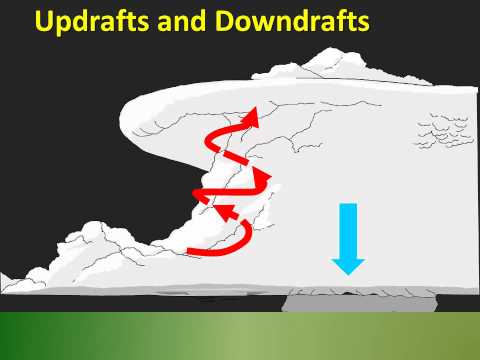
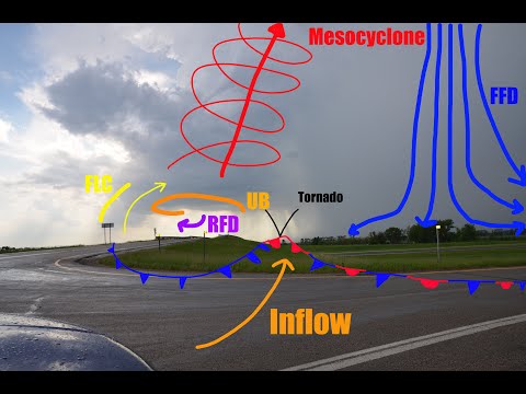
A supercell is characterized by a rotating updraft called a mesocyclone, which sets it apart from other storm types.
Recognizing the signs of a supercell can be crucial for safety and preparedness during severe weather events.
Meteorologists study specific features that indicate the presence of a supercell. These include cloud formation, storm structure, and radar signatures, such as the hook echo.
Understanding these characteristics can help individuals gauge the threat level of an approaching storm.
Spotting a supercell not only enhances one’s ability to stay safe but also fosters a deeper appreciation for the complex nature of severe weather.
Heeding visual and radar cues can make all the difference when a powerful storm threatens an area.
Identification and Characteristics of Supercells

Supercells are distinct due to their organized structure. They consist of a rotating updraft called a mesocyclone. This rotating updraft can lead to dangerous weather events, including tornadoes.
Supercells also feature a bounded weak echo region on radar, indicating a strong updraft.
Additionally, the storm’s downdraft is separate from the updraft. This separation is crucial for the storm’s longevity. The presence of a wall cloud beneath the mesocyclone often suggests a developing tornado.
The hook echo on radar is another telltale sign. As one monitors these signs, it becomes easier to classify the storm.
Key Indicators of Supercell Thunderstorms
There are specific visual signs to look for when identifying supercells. One key indicator is the presence of a v-notch at the storm’s base, showcasing its rotation. A squall line might sometimes accompany these storms, but supercells stand out due to their structure.
Another indicator is high winds associated with severe downdrafts. When combined with significant wind shear, these conditions create a strong potential for supercell formation.
Weather radar can reveal these characteristics effectively. Observing a hook echo pattern indicates rotation and helps confirm a supercell’s presence.
Environmental Conditions Favorable to Supercell Formation
Certain environmental conditions support the development of supercells.
Convection plays a significant role in heating the lower atmosphere. Warm, moist air rises and interacts with cooler, drier air aloft. This mixing enhances instability crucial for supercell formation.
Regions like the Great Plains experience high occurrences due to their geography. The flat terrain allows for better wind flow and development.
The National Weather Service closely monitors these areas to provide timely warnings. Understanding these conditions helps individuals recognize when severe weather may occur, increasing safety during storms.
Impacts and Safety Considerations

Supercell storms can bring various hazardous conditions, making it crucial for individuals and communities to understand the risks and safety measures involved. Preparedness and awareness can significantly reduce the impact of these storms.
Hazards Associated with Supercell Storms
Supercell storms are known for their severe hazards. They can produce tornadoes, which are capable of causing massive damage. Long-lived supercells often lead to widespread destruction.
Additionally, these storms can generate large hail, some larger than softballs, which can damage vehicles and buildings. Flash flooding is another risk, as intense rainfall can overwhelm drainage systems.
Wind gusts associated with these storms can reach over 100 mph, resulting in straight-line winds that can uproot trees and damage structures.
These hazards highlight the importance of understanding the nature of supercell storms and their potential impacts.
Preparation and Response Strategies
Community awareness is key to staying safe during severe weather. Engaging in emergency planning ensures families have a clear plan in case of a storm.
A reliable method is to establish a safe room in your home, away from windows.
Listening to updates from the National Weather Service (NOAA) helps individuals stay informed. Storm spotters play a crucial role by reporting conditions as storms develop.
When a supercell is detected, communities should be prepared to receive emergency alerts for potential tornadoes or flash floods.
Gathering essential items like food, water, medications, and important documents is crucial. Having a communication plan allows families to stay connected during severe weather events.
Role of Weather Monitoring and Forecasting
Weather radar is instrumental in detecting supercell storms.
Meteorologists analyze radar characteristics to identify potential tornadoes and damaging winds.
Storm chasers often track these systems in real-time, providing valuable data for forecasts.
It’s essential for communities to follow these reports, as they can indicate the severity of an approaching storm.
Utilizing weather apps and local news for updates can enhance safety.
Staying alert to changes in the weather is vital for timely action when severe storms are expected.

