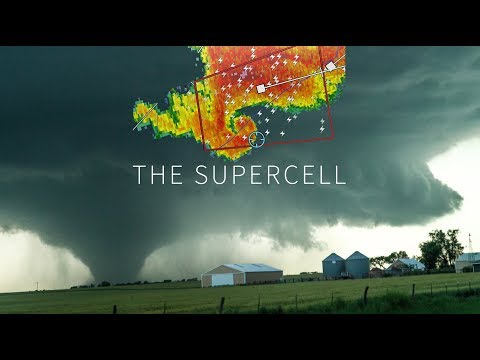
Supercells are among the most powerful types of thunderstorms, known for their severe weather potential. These storms are capable of producing devastating tornadoes, large hail, and damaging winds, making them a significant threat to life and property.
Unlike typical thunderstorms, supercells have a rotating updraft that allows them to persist for hours, often traveling vast distances while maintaining their strength.
The structure of a supercell thunderstorm is highly organized, which contributes to its ability to generate extreme weather. Meteorologists constantly study these phenomena to understand their behavior and predict their paths.
Individuals living in areas prone to severe weather should stay informed about supercells to better prepare for the risks associated with them.
Insights into atmospheric phenomena can enhance awareness and safety during storm season, and learning more about these tremendous storms is vital for everyone. For those seeking to understand more about these atmospheric phenomena, there are numerous articles available on the topic.
Structure and Dynamics of Supercells

Supercells are some of the most powerful types of thunderstorms. Their unique structure and dynamics are essential in understanding their behavior and impact.
Key aspects include the formation of updrafts and downdrafts, along with the influence of wind shear, which helps sustain these formidable storms.
Anatomy of a Supercell
A supercell has a well-defined structure that sets it apart from other thunderstorms. The central feature is the mesocyclone, a rotating updraft that can stretch several kilometers high. The wall cloud, which hangs underneath the mesocyclone, often is where tornadoes form.
Supercells can be categorized into two types: high precipitation (HP) and low precipitation (LP). HP supercells produce heavy rainfall and large hail, while LP supercells generally feature a clearer structure with less rain. The presence of an anvil cloud indicates the storm’s height and strength, spreading out at the top of the storm.
Updrafts and Downdrafts
In a supercell, the updraft plays a crucial role in storm development. The updraft is a strong, vertical wind current that lifts warm, moist air from the surface, nurturing the storm.
As the moisture rises, it cools, condensing into cloud droplets and fueling the storm’s growth.
Conversely, the downdraft is the downward movement of air that usually occurs when rain falls. This cool air descends rapidly, creating a turbulent environment.
The interaction between updrafts and downdrafts helps organize the storm and keep it active for longer periods, often lasting from 1 to 4 hours.
Role of Wind Shear
Wind shear is critical for supercell formation and longevity. It refers to the change in wind speed and direction at different heights.
Effective wind shear helps create the rotation necessary for a strong mesocyclone. Without sufficient shear, the storm may become disorganized and lose strength.
High levels of wind shear in the atmosphere are often present during severe weather, allowing supercells to develop. This dynamic contributes to the storm’s ability to produce severe weather events, including large hail and tornadoes. For more information on the effects of wind, explore Wind – ChaseDay.com.
Supercell-Related Weather Events

Supercells are known for generating severe weather events that can have catastrophic impacts. Key events include tornadoes, hailstorms, and flash flooding, each with unique characteristics and dangers. Understanding these phenomena is crucial for safety and preparedness.
Tornado Development
Tornadoes often form from supercells when conditions are just right. A rotating updraft, known as a mesocyclone, is essential.
As warm, moist air rises and cools, a hook echo can appear on radar, indicating the potential for tornado formation.
In tornado-prone areas like Tornado Alley, these storms can create strong and long-lived tornadoes. Wind shear, or changing wind speeds at different altitudes, also plays a critical role in development. As these conditions align, a funnel cloud may drop from the supercell, creating a dangerous tornado.
Hailstone Formation
Hail develops inside strong thunderstorms, particularly supercells. As updrafts carry water droplets upward, they freeze in extremely cold temperatures at higher altitudes.
This process can cause hailstones to grow larger with each cycle of rising and falling.
Large hail can inflict significant damage. Hailstones, sometimes the size of softballs, can break windows, dent vehicles, and destroy crops. Areas frequently affected by severe storms, like the Great Plains, often experience intense hail events.
Flash Flooding and Damage
Flash flooding is another dangerous outcome of supercells. Heavy rain, often exceeding two inches per hour, can overwhelm drainage systems, causing rapid rises in water levels.
Low-lying areas are particularly vulnerable.
Severe storms can lead to dangerous conditions, including strong winds that exacerbate flooding. Flash flooding can cause property damage and pose serious risks to life.
Knowing local flash flood warnings and understanding the terrain can save lives.
Each of these supercell-related weather events highlights the need for awareness and preparedness during severe weather. Understanding these threats can help individuals respond effectively while ensuring their safety.

