
Supercells are powerful thunderstorms known for their rotating updrafts and potential to produce severe weather. While they are not the most common type of thunderstorm, their unusual structure makes them both fascinating and dangerous.
These storms can form in various regions, but they are most frequent in the central United States, especially in the Great Plains.
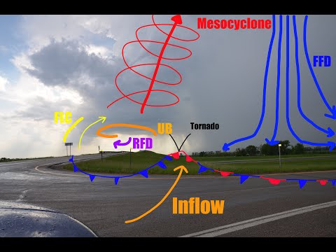
A supercell‘s defining feature is the mesocyclone, a deep, rotating updraft that distinguishes it from other thunderstorms. This unique characteristic allows supercells to generate extreme weather events, including large hail and tornadoes.
Though they are relatively rare compared to standard thunderstorms, understanding their formation and behavior is crucial for predicting severe weather and ensuring safety.
The rarity of supercells does not diminish their impact when they occur. Those who study electrical storms recognize the importance of tracking these systems to prepare for potential hazards. Being informed about how these storms develop can help individuals respond properly when severe weather strikes.
Supercell Characteristics and Formation
Supercells are unique thunderstorm systems known for their potential to produce severe weather, including tornadoes and large hail. Understanding their defining features, types, and the environmental conditions necessary for their formation is essential to grasp their significance in meteorology.
Defining Features
The main characteristic of a supercell is the presence of a mesocyclone, a rotating updraft that allows the storm to maintain its strength for an extended period. This rotation distinguishes supercells from other types of thunderstorms.
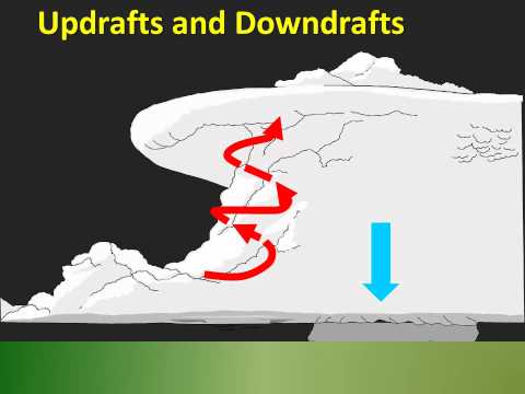
Typically, they consist of three main parts: the updraft, the downdraft, and the anvil-shaped cloud at the top.
Supercells often produce tornadoes, damaging winds, and very large hail due to their intense dynamics. The rotating updraft can extend vertically through the troposphere, creating significant differences in pressure. These storms are categorized into two main types based on precipitation: classic supercells, which have a well-defined updraft structure, and high-precipitation supercells, which can obscure their rotation due to heavy rain.
Types of Supercells
Supercells are mainly classified into three types based on their structure and precipitation characteristics:
-
Classic Supercell: Characterized by a well-defined rotating updraft and anvil cloud with often visible features enhancing tornado formation.
-
High-Precipitation (HP) Supercell: These storms have heavy rain and hail that can hide the structure of the storm, making observing tornadoes more difficult.
-
Low-Precipitation (LP) Supercell: These tend to have less rain and can produce larger hail, but they often lack the visibility of the classic type due to minimal precipitation.
The characteristics of these types contribute to the storm dynamics in regions like Tornado Alley, where supercell thunderstorms frequently occur.
Environmental Conditions
The formation of supercells requires specific environmental conditions. One crucial factor is vertical wind shear, which refers to the change in wind speed and direction with altitude. This shear helps to organize storm rotation.
Additionally, buoyancy, determined by the CAPE (Convective Available Potential Energy), fuels the updrafts needed for supercell development.
A favorable environment includes warm, moist air at the surface with cooler, drier air aloft. Together, these conditions help spark intense convection in the atmosphere.
Understanding these elements is essential for predicting severe weather events, particularly relating to supercell thunderstorms. For insights on related atmospheric phenomena, researchers can explore more about environmental impacts on storm formation.
Impact and Detection of Supercells
Supercells have significant impacts on weather patterns and can lead to severe weather events. These storms are often detected through advanced technologies, enabling meteorologists to warn communities effectively.
Severe Weather Phenomena
Supercell thunderstorms are distinct for their rotating updraft, known as a mesocyclone. These storms can produce dangerous weather phenomena including tornadoes, hail, damaging winds, and flash flooding.
The downdraft in supercells can be intense, leading to severe thunderstorms that pose significant risks to life and property.
A specific feature associated with supercells is the bounded weak echo region, which often indicates a strong updraft and the potential for tornado development.
Many regions experience violent tornadoes that can cause catastrophic damage. Understanding these phenomena helps in preparing for severe weather events and mitigating risks.
Supercell Forecasting and Observation
Detection of supercells relies on various technologies and methods. Doppler radar plays a crucial role in monitoring storm development. This enables meteorologists to analyze wind speeds and movement patterns.
The National Weather Service and local storm spotters utilize radar data and satellite imagery to track supercells in real time. This information is essential for issuing timely warnings to the public.
In countries like Australia, agencies such as the Bureau of Meteorology employ similar technologies for effective forecasting. Accurate detection allows communities to take necessary precautions and reduce the impact of severe weather associated with supercells.