Identifying a supercell can be essential for those interested in severe weather phenomena.
A supercell is a type of thunderstorm characterized by a rotating updraft known as a mesocyclone, making it distinctly different from other storm types.
Recognizing the visual signs of a supercell can help individuals stay safe, especially in regions prone to tornadoes.
Visual clues can include a well-defined structure with a rising tower, often accompanied by an anvil-shaped cloud. The presence of a wall cloud, which hangs beneath the main cloud base, can also indicate the potential for a supercell.
These features are crucial for recognizing a storm that poses severe weather risks.
Understanding the characteristics of supercells not only aids storm chasers but also helps the general public prepare for the dangers associated with severe weather. Knowing these signs could make a significant difference in safety during intense storm events.
Characteristics of Supercell Thunderstorms

Supercell thunderstorms have unique features that set them apart from regular storms. They are known for their rotating updrafts and complex structure. Understanding these characteristics can help in identifying supercells and their potential for severe weather.
Recognizing the Signs of a Supercell
To spot a supercell, look for distinct visual signs. The presence of a mesocyclone is key. This is a deep, rotating updraft that indicates the storm’s intensity.
Additionally, a wall cloud often forms beneath the mesocyclone. This lowering indicates moist air being pulled into the storm.
Other notable features include the hook echo on radar, which suggests rotation and possible tornado development. A flanking line of clouds may develop along the storm’s edge, further signaling the presence of a supercell.
Components of a Supercell
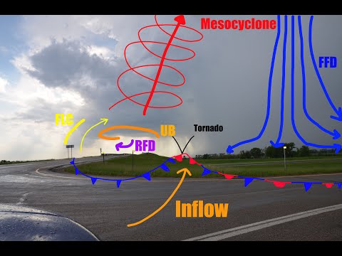
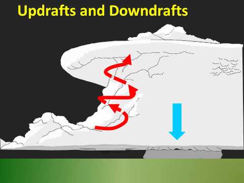
Supercells consist of several critical components. The rotating updraft is the heart of the storm, allowing for sustained energy. This updraft can split into two streams: the forward flank downdraft (FFD) and the rear flank downdraft (RFD).
The FFD typically brings heavy rain, while the RFD is associated with clearing skies and rotation.
Cumulonimbus clouds often dominate the sky, forming a towering structure indicative of severe weather. Understanding these components is essential for storm tracking and prediction.
Supercell and Severe Weather
Supercells are capable of producing severe weather events. These storms are linked to tornadoes, hail, and damaging winds. The strength and organization of the mesocyclone allow supercells to persist for hours.
Heavy precipitation occurs but can vary between low and high amounts, creating different storm types. A low precipitation (LP) supercell will show less rain, while a high precipitation (HP) supercell features heavy downpours.
Knowing these differences can aid in assessing storm impacts. Monitoring factors such as surface movement is critical in predicting how these storms will develop and behave.
For more about severe weather conditions, visit articles related to electrical storms and surface movement.
Identifying and Understanding Severe Weather Patterns Associated with Supercells

Recognizing the severe weather patterns linked to supercells is crucial for predicting their behavior and potential impact. This knowledge helps in understanding the risks involved, including large hail, damaging winds, and tornado formation.
The Role of Environmental Factors
Environmental factors play a significant role in the development of supercells. Specific conditions are essential for these storms. Key elements include moisture, instability, and wind shear.
-
Moisture: Adequate moisture in the atmosphere helps fuel storm formation. High humidity enhances the chances of strong thunderstorms, making it vital for supercell development.
-
Instability: A warm, moist surface air layer combined with cooler air aloft creates instability. This setup allows thunderstorms to grow vertically, leading to more intense weather events.
-
Wind Shear: Changes in wind speed and direction with altitude create the rotation necessary for supercells. For example, strong wind shear can contribute to the rotation of storm updrafts, increasing the likelihood of tornadoes.
Understanding these factors is essential for spotting developing supercells and assessing their severity.
Differentiating Supercell Types
Supercells can be categorized into three main types: Classic, High-Precipitation (HP), and Low-Precipitation (LP). Each type has its distinct characteristics and associated weather threats.
-
Classic Supercells often exhibit a well-defined rotation and can produce large hail and damaging winds. These are typically located in open areas, making them easier to spot.
-
HP Supercells usually produce significant rainfall and can obscure tornadoes, making these storms particularly dangerous. This type is more common in regions with high moisture, where the risk of flash flooding increases.
-
LP Supercells have lower precipitation and are often associated with strong damaging winds and hail. They can move rapidly, striking quickly without much warning.
By identifying these types, meteorologists can better predict the potential impacts associated with each supercell.
Associated Weather Events
Supercells are notorious for the severe weather events they can produce. Understanding these events helps in risk assessment.
-
Large Hail: One of the most common hazards is hail, which can grow in size and cause significant property damage.
-
Damaging Winds: Winds can exceed 100 mph, causing destruction as they push through neighborhoods.
-
Tornadoes: Supercells are responsible for the most severe tornadoes. They can be intense and long-lived, often occurring in the vicinity of HP supercells.
-
Flash Flooding: Heavy rainfall can lead to rapid flooding, especially in urban areas. The combination of intense rainfall and poor drainage systems increases this risk.
-
Downbursts: These powerful downdrafts can cause sudden, damaging winds that pose a significant threat.
Recognizing these associated weather events can provide vital clues about the potential dangers of an approaching supercell. Understanding these patterns enhances preparedness and safety during severe weather situations.
