
Understanding how to tell if a hurricane is coming can greatly impact personal safety and preparedness. The signs of an approaching hurricane can often be subtle, but there are specific indicators to watch for.
Monitoring updates from the National Hurricane Center and staying informed about hurricane watches and warnings issued by NOAA can provide crucial information.
Hurricane season runs from June to November, and it’s essential to stay alert during this time.
Local weather alerts may indicate shifting conditions, which can signal an incoming storm. It’s also important to recognize the difference between a hurricane watch, meaning conditions are possible, and a hurricane warning, indicating that a storm is likely to make landfall soon.
Being proactive can make a significant difference. Knowing where to find reliable information and understanding early warning signs can help individuals prepare and respond effectively when a hurricane threatens their area.
Keeping an eye on weather reports and heeding evacuation orders are vital steps in staying safe.
Understanding Hurricane Alerts and Predictions

Hurricane alerts and predictions are essential for public safety during severe weather events. The National Hurricane Center plays a significant role in this process, utilizing advanced tools and data to provide timely information.
Key components like weather data and satellite imagery are crucial for understanding tropical cyclones and their potential impacts.
The Role of the National Hurricane Center
The National Hurricane Center (NHC) is the primary authority on hurricane forecasting in the United States. It monitors tropical storms and cyclones, issuing timely alerts to inform the public.
Meteorologists at the NHC analyze data from various sources, including satellites and weather stations, to predict storm paths and wind speeds.
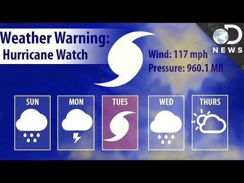
The NHC provides alerts such as “Hurricane Watch” and “Hurricane Warning.” A Hurricane Watch indicates that hurricane conditions are possible within the next 48 hours, while a Hurricane Warning means conditions are expected within 36 hours. Understanding these alerts allows individuals to prepare adequately for potential impacts, including storm surges and high winds.
Interpreting Weather Data
Weather data is vital for predicting hurricane behavior and intensity. Key metrics include wind speed, rainfall, and pressure readings.
Meteorologists use this data to create models that simulate storm development and track their paths.
One crucial element is the Saffir-Simpson Hurricane Wind Scale, which classifies hurricanes into categories based on sustained wind speed. This scale helps gauge potential damage. For example, a Category 1 hurricane has winds of 74-95 mph and can cause minor damage, while a Category 5 hurricane exceeds 157 mph, leading to catastrophic consequences.
Public access to this data has improved, aiding personal preparedness. Websites and mobile apps provide real-time updates, allowing individuals to stay informed about rapidly changing conditions.
The Importance of Satellite Imagery
Satellite imagery is a powerful tool in hurricane forecasting. It provides a bird’s-eye view of storm systems, allowing meteorologists to assess their structure and movement.
This imagery helps identify features such as eye formation and surrounding thunderstorms, which influence a storm’s intensity.
Modern satellites can monitor sea surface temperatures and weather patterns, essential for understanding how tropical storms may develop into hurricanes. Additionally, satellite data helps predict the areas most at risk for storm surges or heavy rainfall, enabling effective evacuation plans.
By combining satellite imagery with ground-level observations, forecasting accuracy improves significantly, helping communities prepare for the impacts of hurricanes. Understanding this technology is crucial for anyone wanting to stay safe during hurricane season.
Recognizing Natural Warning Signs
Natural warning signs can provide crucial information about an approaching hurricane. Awareness of atmospheric changes, oceanic behavior, and local weather patterns can greatly increase preparedness. Understanding these signals helps individuals take necessary precautions.
Changes in Atmospheric Conditions
One of the first indicators of a hurricane is a drop in barometric pressure. This can signify that a storm is approaching. As a hurricane forms, the air pressure decreases, causing wind speeds to increase. Observing cloud formations also plays a role. Cumulus clouds may start to appear fluffier and darker.
Additionally, watch for cirrus clouds, which can signal changes in the atmosphere. If these clouds thicken, it could indicate an impending storm. Increased wind speeds are another sign of an approaching hurricane. These changes are critical when monitoring for severe weather events.
Observing Oceanic Behavior
Ocean behavior can also reveal signs of an approaching hurricane. Increased wave frequency and height may start to be noticeable. Additionally, one might observe strong rip tides pushing away from the shoreline, indicating that a storm is near.
Another significant factor is the possibility of a life-threatening storm surge. This surge can lead to inland flooding, increasing the urgency for coastal residents to prepare. If ocean waters seem unusually rough, it is a good idea to stay alert. Understanding these oceanic changes allows people to anticipate the severity of the impending storm.
Monitoring Local Weather Patterns
Keeping an eye on local weather forecasts is essential in hurricane season.
Changes in rainfall patterns can indicate a storm’s approach. If heavy rain begins suddenly, especially after a dry spell, it may suggest a hurricane nearby.
Storm surge watches and warnings will often accompany hurricane alerts.
Being aware of local notifications keeps residents informed about potential flooding risks. It is vital to act quickly, as flooding can occur rapidly in severe storms.
Monitoring these patterns can help ensure safety during dangerous weather events.