
Supercells are a special type of thunderstorm known for their rotating nature and potential to produce severe weather events.
The three types of supercells are low-precipitation (LP), classic, and high-precipitation (HP). Each type has distinct characteristics that determine the severity of weather conditions, including the likelihood of tornado formation and the size of hail that can occur during these storms.

Understanding these supercell types is essential for meteorologists and storm chasers alike.
LP supercells often produce less rainfall but can still lead to significant tornado activity. In contrast, HP supercells bring heavy rain and can cause flash flooding. Classic supercells fall somewhere in between, featuring a balanced mix of precipitation and wind shear that can generate severe thunderstorms.
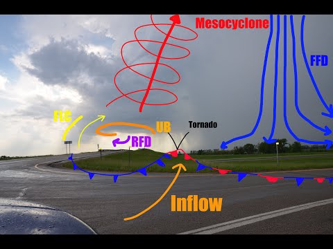
As storms develop, the presence of a mesocyclone—a rotating updraft—can signal the potential for severe weather. This understanding aids the Storm Prediction Center in issuing timely warnings to protect lives and property.
Grasping the differences between supercell types not only helps in forecasting but also prepares communities for possible impacts from tornadoes and hail.
Types of Supercells

Supercells are a specific type of thunderstorm known for their rotating nature and distinct characteristics. They can significantly impact severe weather outcomes, including tornadoes and heavy rainfall.
The three main types of supercells are Classic Supercells, Low Precipitation Supercells, and High Precipitation Supercells.
Classic Supercells
Classic supercells are the most recognizable type of supercell. They often produce large hail, strong winds, and tornadoes.
A key feature of classic supercells is the rotating updraft, known as a mesocyclone. This rotation is crucial for forming wall clouds, which can develop into tornadoes.
Classic supercells typically exhibit a hook echo on Doppler radar, indicating potential severe weather. These systems usually have a well-defined structure, with a clear separation between the updraft and the downdraft. As a result, they can lead to significant damage from both tornadoes and straight-line winds. Their long lifespan, often ranging from 1 to 4 hours, allows for extended periods of severe weather impacts.
Low Precipitation Supercells
Low Precipitation (LP) supercells are characterized by a lack of significant rainfall during their development. These storms usually form in an environment with dry air aloft, leading to lower dewpoint depression.
Due to this dry air, LP supercells can produce large hail and tornadoes, but with less overall precipitation.
LP supercells tend to be higher-based than other types. The updraft must rise higher into the atmosphere to cool and condense. This results in impressive storm visuals but can lead to stronger downdrafts as the precipitation does finally descend. Flash flooding is less common, but LP supercells can still be severe, particularly when they spawn tornadoes.
High Precipitation Supercells
High Precipitation (HP) supercells are known for producing heavy rainfall and are often accompanied by flash flooding. These storms can create rain-wrapped tornadoes, making them difficult to spot.
The high moisture content in the atmosphere contributes to significant downdraft activity, which can lead to heavy precipitation rates.
HP supercells are typically low to the ground, often resulting in rapid increases in rainfall rates. The forward-flank downdraft can cause damaging winds and heavy rain, while the rear-flank downdraft is crucial for tornado development. The risks associated with HP supercells include flooding and extensive storm damage due to strong winds, making them a significant concern for weather professionals.
Supercell Dynamics and Impact
Supercells are powerful thunderstorms that rely on specific dynamics to form and create severe weather.
Understanding the role of wind shear and the various weather phenomena associated with these storms is essential for predicting their potential impact.
Wind Shear and Supercell Formation
Wind shear is the change in wind speed and direction with altitude. It plays a crucial role in the development of supercells, especially in the Great Plains.
Strong wind shear allows for the rotation that leads to the formation of a mesocyclone.
High levels of moisture are also necessary. The energy available for storms, measured as CAPE (Convective Available Potential Energy), increases with moisture.
When these conditions are met, the supercell can create a well-defined anvil, which is the flat top of the storm. Strong directional and speed shear contributes to storm-relative wind patterns, enhancing the storm’s rotation and stability.
The combination of these factors makes supercells capable of producing severe weather, such as damaging winds, large hail, and even tornadoes.
Weather Phenomena Associated with Supercells
Supercells can produce various severe weather events. These include strong straight-line winds and derechos, which are widespread, long-lived wind events.
The organized structure of supercells allows them to create a radar signature indicative of severe weather, which meteorologists use for warnings.
Lightning and flash flooding are also common with these storms. Heavy rainfall can lead to significant precipitable water, causing flash flooding in susceptible areas.
Furthermore, supercells can sometimes merge with other storms to form a squall line, increasing the threat of severe conditions.
Understanding these phenomena is vital for accurate forecasting and public safety, as warnings from the Storm Prediction Center help inform communities about potential risks.