
Supercells are some of the most severe thunderstorms on Earth, known for their potential to produce dangerous weather. These storms are caused by specific atmospheric conditions, including higher wind shear and instability in the atmosphere.
In these storms, warm, moist air rises and interacts with cooler, drier air above, creating a rotating updraft, which is called a mesocyclone. This unique structure can lead to damaging winds, large hail, and even tornadoes.
The National Oceanic and Atmospheric Administration (NOAA) and the National Severe Storms Laboratory (NSSL) study these powerful storms to improve forecasting and safety measures. Understanding the formation of supercells helps meteorologists predict severe weather events. As a result, communities can prepare for potentially catastrophic conditions, from destructive hail to intense tornadoes.
By learning more about what causes supercells, readers can appreciate the complexities of severe weather. These storms often have a devastating impact, emphasizing the need for awareness and preparedness in the face of extreme atmospheric phenomena. The science behind supercells is a fascinating blend of meteorology and nature’s power that intrigues both weather enthusiasts and the general public alike.
Formation and Structure of Supercells
The development of supercells relies on specific atmospheric conditions and unique structural components. Understanding these factors helps explain why supercells are both rare and intense.
Atmospheric Conditions Leading to Supercell Development
Supercells form in environments with plenty of moisture and instability. The air needs to rise, becoming buoyant.
Buoyancy occurs when warm, moist air near the ground rises through cooler, dense air above it. This creates strong updrafts.
Wind shear, particularly vertical wind shear, is also crucial. This refers to changes in wind speed and direction with height.
High wind shear allows the updraft to rotate and helps maintain its strength. When wind speeds vary significantly, they create a dynamic environment that significantly contributes to the growth of supercells.
Combining these conditions allows supercells to develop and maintain themselves.
Characteristics of Rotating Updrafts and Mesocyclone Formation
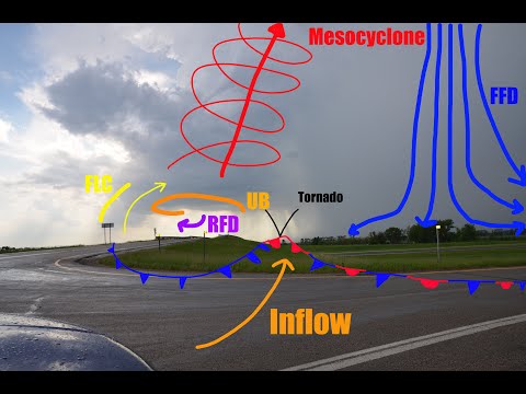
At the core of a supercell is the rotating updraft, often called a mesocyclone. A mesocyclone forms when the updraft begins to rotate due to vertical wind shear. This rotation is essential for the storm’s intensity and longevity.
As the air rises, it begins to twist and spiral, creating a strong rotating updraft. This updraft can reach speeds of over 100 mph.
The rotation helps organize the storm and can lead to severe weather, such as large hail or tornadoes. The combined action of the rotating updraft and the surrounding wind patterns forms a powerful storm system, making supercells one of the most dangerous types of thunderstorms.
More information can be found about wind conditions that contribute to supercell formation.
Characteristic Features and Types of Supercells

Supercells are unique thunderstorms distinguished by their rotating nature and potential for severe weather. Understanding their types and features is crucial to predicting their behavior and impact.
Low Precipitation (LP) and High Precipitation (HP) Supercells
Supercells can be classified into two main types: Low Precipitation (LP) and High Precipitation (HP) supercells.
LP supercells are characterized by a small amount of rain but can produce large hail and strong winds. The lack of precipitation allows for better visibility of the structure, making them easier to observe and study.
In contrast, HP supercells contain significant rain and may lead to flash flooding. This type often produces damaging winds and can spawn tornadoes. The heavy precipitation can obscure the storm’s core, making it harder to identify key features like the wall cloud.
Both types can cause large hail and contribute to significant weather events, like tornadoes.
Identification of Supercell Components through Radar
Radar technology plays a crucial role in identifying supercell features. Meteorologists examine radar reflectivity to assess rainfall intensity and storm structure.
Key components include:
- Wall Cloud: This area of lowered cloud base is crucial for tornado development.
- Hook Echo: A radar signature that indicates rotation and potential tornado formation.
- Downdrafts: Supercells exhibit two main downdraft types: Forward Flank Downdraft (FFD), which is generally cooler and moist, and Rear Flank Downdraft (RFD), which is drier and plays a significant role in storm rotation.
Identifying these features helps in issuing timely warnings to mitigate the risks of damaging winds, tornadoes, and downbursts.
Major Supercell Events and their Impact
Throughout history, several major supercell events have had devastating impacts. Events like the 2011 Joplin tornado and the 2013 El Reno tornado showcase the destructive power of these storms.
These supercells can produce significant tornadoes, large hail, and damaging winds.
Tornadoes associated with supercells can lead to significant destruction and loss of life.
Additionally, HP supercells may result in severe flash flooding, creating hazardous conditions.
Understanding the history and impacts of supercell events is vital for improving preparedness and response strategies in affected areas. Recognizing the characteristics of these storms allows meteorologists to communicate risks effectively.