
Squall lines are a common feature of severe weather, often appearing as a line of powerful thunderstorms. These lines are primarily caused by atmospheric instability combined with a cold front, creating conditions that foster rapid storm development.
As warm, moist air rises and cools, it can lead to heavy rain, strong winds, and even tornadoes.
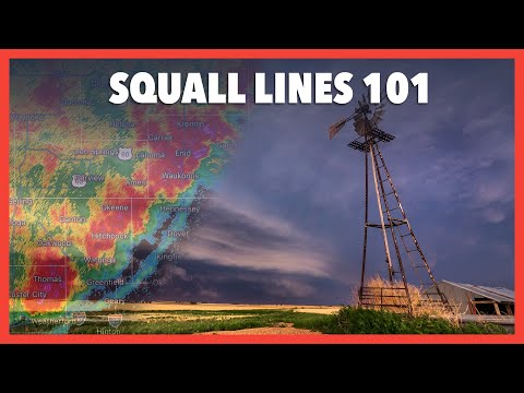
Meteorologists use radar to track these squall lines as they develop, making it possible to predict severe weather patterns. The interaction between different air masses plays a crucial role in the formation of squall lines, often occurring in the warm sector of a cyclone.
Understanding the dynamics of these storms helps to explain why they can produce such intense weather phenomena.
By recognizing the signs of squall lines, individuals can better prepare for the associated dangers. Readers can explore more about these atmospheric events and their impact on weather patterns by visiting articles on atmospheric phenomena.
Formation and Characteristics of Squall Lines
Squall lines are organized lines of thunderstorms that develop under specific meteorological conditions. Understanding their formation and key characteristics helps better predict severe weather events.
Meteorological Conditions Leading to Squall Lines
Squall lines often form along or ahead of a cold front. This cold air pushes under warm, moist air, causing the warm air to rise. The lifting can create instability, which is crucial for thunderstorm development.
Vertical wind shear is also important; it refers to changes in wind speed and direction with height. When strong wind shear exists, it helps organize storms into a line.
The combination of moisture, instability, and wind shear sets the stage for these dangerous weather phenomena.
Physical Structure and Evolution
A squall line typically starts as a mesoscale convective system (MCS). During the mature stage, it develops a bow echo, which is a curved shape due to differences in wind speeds.
As the storm evolves, gust fronts push cold air ahead, enhancing upward motion in the warm air. This interaction strengthens the thunderstorms and can lead to severe weather, including heavy rain and strong winds.
The trailing stratiform rain area often forms behind the squall line. This area is calmer but can still produce significant precipitation.
Eventually, the squall line enters the dissipating stage, where the thunderstorms weaken and rain diminishes.
Types of Squall Lines
Squall lines are primarily classified into two types: continuous and discrete. Continuous squall lines consist of a series of thunderstorms that are closely spaced together. Conversely, discrete squall lines have more separation between individual cells.
These lines can also be associated with various types of thunderstorms. For instance, multi-cell thunderstorms can create a continuous line, while supercell thunderstorms may contribute to a discrete pattern.
Each type presents unique challenges for pilots and meteorologists, especially regarding flight safety, as squall lines can be dangerous to navigate.
Impacts of Squall Lines

Squall lines can lead to various severe weather events and have significant effects on both the environment and human activities. Understanding these impacts helps in preparation and safety during such weather phenomena.
Severe Weather Events
Squall lines are often associated with severe weather conditions. They can bring heavy rain, leading to flash flooding, especially in low-lying areas.
The downdrafts from these systems can create dangerously high winds, sometimes exceeding 60 mph, resulting in damaging winds that can uproot trees and down power lines.
Lightning is another hazard during squall line events, posing risks to outdoor activities and infrastructure. The intense rainfall may also produce large hail, which can damage crops and vehicles.
In some cases, squall lines can spawn tornadoes, particularly when they develop in unstable atmospheric conditions. The effects of these severe weather events can be widespread, affecting communities, agriculture, and emergency services.
Detection and Predictive Technologies
Modern radar technologies play a crucial role in detecting squall lines.
Meteorologists use radar reflectivity to visualize precipitation and identify the structure of storms. This helps in understanding potential hazards, such as hail and winds.
Radar imagery can also reveal features like shelf clouds and outflow boundaries, which indicate the presence of a squall line.
Advanced prediction models consider various factors, enabling better forecasting of heavy precipitation and severe events.
As technology evolves, improved detection and predictive capabilities enhance safety and preparedness for communities prone to these weather phenomena.