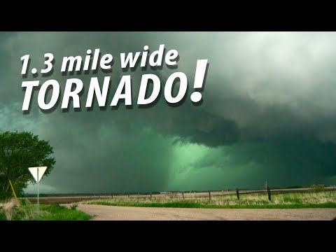
In the world of severe weather, the color of the sky can tell a lot about what is to come. Before a tornado, the sky often turns a striking shade of greenish or yellowish, indicating that a severe storm may be nearby.
This color change occurs due to the unique interaction between sunlight and heavy storm clouds. Meteorologists, with years of experience studying atmospheric phenomena, note that while a blue sky might precede a light shower, a dark, turbulent sky signals something more serious.
Tornadoes form from powerful storm systems, and the ominous sky is a signal that conditions are ripe for extreme weather.
As storm clouds gather and the atmosphere becomes unstable, observers can see dramatic color shifts. The greenish hue is often associated with intense thunderstorms, which can produce hail and tornadoes.
Understanding this connection can be essential for those living in tornado-prone areas, where knowing the signs can make a difference.
For a deeper dive into weather-related topics, check out discussions on atmospheric phenomena.
While not every storm with a green sky results in a tornado, it serves as an important warning.
Keeping an eye on the sky and recognizing these signals can help individuals prepare for potential danger.
Knowledge about weather patterns and changes can empower people to take action when severe weather threatens their safety.
The Science of Sky Colors Before Tornadoes

The colors of the sky before a tornado can provide crucial clues about impending severe weather. These colors result from complex interactions between light, water droplets, and particles in the atmosphere.
Understanding these processes reveals how the sky transforms, signaling the presence of a thunderstorm or funnel clouds.
Understanding Light Scattering
Light scattering plays a vital role in how colors appear in the sky. When sunlight passes through the atmosphere, its light spectrum is affected by particles, including dust and water vapor.
Shorter wavelengths, like blue, scatter more than longer wavelengths, such as red.
In a severe thunderstorm, dense clouds formed by water droplets can change this dispersion. The blue light is scattered, often allowing longer wavelengths to dominate the view.
This can lead to a greenish or yellowish sky as the sunlight interacts with the storm clouds, a common indicator of potential tornado activity.
Role of Water Droplets and Particles in Air
Water droplets are crucial in altering the sky’s color before a tornado. As thunderstorm clouds build, they accumulate large amounts of moisture. This concentration of water droplets causes significant light scattering.
Additionally, particles in the air—like pollutants or dust—also contribute to the scattering phenomenon. When the atmosphere is heavy with these particles, they can enhance the yellow and orange hues visible in the sky.
As thunderstorms develop, the interaction between light, water, and particles creates vibrant colors. These changes can signal the intensity of the storm and the possible formation of funnel clouds.
The appearance of a green sky often alerts observers to the potential for severe weather.
Weather Patterns and Tornado Indicators

Weather patterns play a crucial role in predicting tornadoes. Certain sky colors and cloud formations serve as warning signs. Understanding these indicators can help people stay safe during severe weather.
Unusual Sky Colors and Tornadoes
One of the most recognized indicators of an impending tornado is the unusual color of the sky. A greenish hue often appears before severe thunderstorms. This color comes from the way sunlight interacts with thunderstorm clouds.
The greenish-black skies can come with large hail, which also suggests danger. Meteorologists, like Scott Bachmeier, note that while a green sky is not a guarantee of a tornado, it is an important sign of extreme weather.
As the atmosphere becomes unstable, this unusual color can signal the presence of a dramatic updraft.
Advanced Warning Signs of Tornadoes
Several advanced warning signs can indicate a potential tornado. The appearance of a wall cloud, a low-hanging cloud beneath a thunderstorm, is often a precursor to tornado formation.
Additionally, if there are sudden shifts in wind direction or intensity, it may signal that severe weather is approaching.
Large hail is another significant warning sign. Hailstorms usually happen before tornadic activity begins.
It is critical to remain alert during these conditions, as the transition from a severe storm to a tornado can happen rapidly. Recognizing these signs can provide valuable time for people in Tornado Alley to seek safety.
Research and Findings by Meteorologists
Meteorologists have extensively researched the phenomena associated with tornadoes.
Studies show that certain weather patterns, like the development of greenish-yellow or greenish-black skies, often occur during severe storms capable of producing tornadoes.
As the storm grows, updrafts can intensify, leading to the formation of a tornado.
Additionally, research indicates that the presence of a strong electrical storm can increase the likelihood of tornado development. Understanding these patterns contributes to more accurate forecasting.
Meteorologists continue to analyze these indicators to improve safety measures and early warnings for people in high-risk areas.
For more insights into electrical storms, check out articles on Electrical Storms.
