
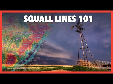
A squall line is a fascinating meteorological phenomenon that forms when a series of thunderstorms develop along or ahead of a cold front.
These thunderstorms are created by updrafts that lift warm, moist air upward, leading to heavy rain and severe weather conditions. Meteorologists closely monitor these systems using radar, as squall lines can bring strong winds, hail, and even tornadoes.
Understanding what creates a squall line is crucial for predicting severe weather events. These lines of storms can stretch for hundreds of miles and cause extensive damage.
As they move, they can result in sudden heavy rain and dangerous conditions for anyone caught in their path.
Watching a squall line form is a reminder of nature’s power and complexity. With the right conditions, including the presence of low pressure and ample moisture, these storms can develop swiftly.
Keeping an eye on weather reports can help individuals stay informed and safe during such intense weather events.
Characteristics and Development of Squall Lines
Squall lines are distinct weather phenomena characterized by a series of thunderstorms that form in a linear arrangement. Their development is influenced by specific meteorological conditions, including temperature differences and wind patterns. Understanding these features aids in predicting their behavior and potential impacts.
Squall Line Structure and Features
A squall line typically contains several individual thunderstorms, often in a linear formation. These storms can extend hundreds of miles in length but are relatively narrow, usually only 10 to 20 miles wide.
Cumulonimbus clouds are common, forming the basis for the thunderstorms.
Shelf clouds often accompany squall lines, creating a visible, low-hanging formation. These clouds indicate the boundary between warm, moist air and cooler air, signaling the storm’s presence.
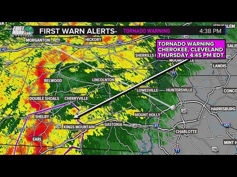
Gust fronts can also develop, which are created when cold air from the storm downdrafts spreads out. The presence of radar imagery is crucial for tracking squall lines and assessing their intensity and movement.
Formation Process
Squall lines generally form along or ahead of a cold front, where warm, moist air meets cooler, denser air. This interaction creates instability, which is essential for thunderstorm development.
Wind shear, or changes in wind speed and direction with height, supports the formation and organization of these storms.
The updrafts within the storm cells are strong, allowing for heavy precipitation and severe weather. These updrafts sustain the thunderstorms, enabling them to persist over time.
Under specific conditions, squall lines can lead to extreme weather events such as bow echoes or derechos, which are severe wind events that can cause significant damage.
Types and Variations
Squall lines can vary in intensity and structure, often categorized into two main types: linear and quasi-linear convective systems (QLCS). The linear type consists of a more straightforward line of storms, while QLCS may exhibit more complex features.
Commonly, squall lines develop in the warm sector of a cyclone, positioned ahead of a cold front. Their powerful thunderstorms are often associated with heavy precipitation and severe winds. Recognizing these types is essential for meteorologists, as each variation presents different potential threats to safety. For more insights into storm dynamics, one can explore topics related to atmospheric phenomena.
Impact of Squall Lines
Squall lines can lead to various severe weather phenomena that pose threats to both life and property. Understanding these impacts is crucial for effective safety measures and preparedness, particularly in aviation and residential areas.
Weather Phenomena Associated With Squall Lines
A squall line is often linked to intense weather events. These lines can produce heavy rainfall, leading to localized flooding. They can also create damaging winds, which sometimes exceed 60 miles per hour, resulting in downed trees and power lines.
Such squall lines frequently spawn tornadoes, adding to the danger. Meteorologists monitor these situations closely using data from the Storm Prediction Center to warn communities.
Additionally, squall lines can create conditions for severe turbulence and visibility issues for pilots.
The occurrence of hail and straight-line winds is also common. These features necessitate careful flight planning, especially for those at the aviation weather center who aim to minimize risks to air travel.
Safety and Preparedness
Safety measures are essential when squall lines approach.
People should stay informed by monitoring weather updates from authorities like the Storm Prediction Center.
During a squall line event, it is advisable to seek shelter away from windows.
In areas prone to heavy rain and flooding, having an emergency kit prepared can be life-saving.
Homeowners should clear drains and gutters to reduce flooding risks.
For pilots, staying updated on weather conditions is critical.
They should use resources that provide real-time updates on wind patterns and turbulence.
Proper precautions can minimize dangerous situations during flights impacted by squall lines.