
Squall lines are fascinating atmospheric phenomena that play a significant role in severe weather development. They most often form ahead of a cold front.
As these lines advance, they can trigger strong thunderstorms characterized by high winds, heavy rain, and even tornadoes. Understanding their formation can help people prepare for the impactful weather that often accompanies them.
The dynamics of squall lines are influenced by various factors, including wind shear, which creates the necessary turbulence for storm development.
Updrafts and downdrafts contribute to the formation of these intense storms. When warm, moist air meets cooler air at a cold front, the resulting instability can lead to the development of severe thunderstorms within a squall line.
Meteorologists continuously study these systems to improve safety and preparedness for those in their path. For more in-depth information on atmospheric phenomena, readers can explore related topics that provide insights into the intricate workings of our weather systems.
Mechanics of Squall Line Development

Squall lines are complex weather systems that form under specific conditions. They typically develop ahead of cold fronts and involve various atmospheric processes, including wind shear and moisture dynamics.
Understanding these mechanics is essential to grasp how squall lines evolve and affect weather patterns.
Role of Cold Fronts and Wind Shear
Squall lines often develop ahead of cold fronts, where warm, moist air meets colder air. The cold front forces the warm air to rise rapidly, creating instability. This rising air is crucial for thunderstorm development.
Wind shear, which is a change in wind speed and direction with height, also plays a significant role. It enhances the formation of thunderstorms along the squall line.
Increased wind speed generally leads to stronger updrafts and, consequently, more intense storms. Wind shear can also contribute to turbulence, making the environment conducive to severe weather.
Updrafts and Downdrafts in Squall Lines
In squall lines, updrafts and downdrafts are critical elements. Updrafts occur when warm air rises, drawing moisture up. This rising moisture condenses into clouds and precipitation. The strength of these updrafts significantly affects storm intensity.
As precipitation falls, it cools the surrounding air, leading to downdrafts. Downdrafts are the descending currents of air that can increase surface wind speeds.
This process creates a gust front, which can help generate new thunderstorms along the line. The interaction between updrafts and downdrafts is vital for the lifecycle of the squall line.
Formation and Lifecycle of Squall Lines
Squall lines typically form when there is a combination of moisture, lift, and instability. Initially, a well-defined boundary, often a cold front, creates the necessary lift.
As the squall line matures, it can last for hours, producing heavy precipitation and gusty winds.
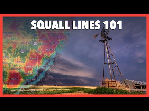
The lifecycle of a squall line includes periods of intensification and weakening. Radar can help track these developments by showing changes in storm structure and intensity.
As the squall line moves, it continues to influence weather far beyond its original formation area. Monitoring these systems ensures accurate predictions for those affected by severe weather conditions.
Impacts and Manifestations of Squall Lines
Squall lines can lead to intense weather phenomena that have significant impacts on the environment and communities. They can produce severe thunderstorms, tornadoes, and damaging winds. Understanding these impacts helps in predicting and preparing for potentially dangerous situations.
Manifestations: Tornadoes and Derechos
Squall lines often create conditions ripe for tornado formation, particularly in the warm sector ahead of a cold front. When strong winds shear through the atmosphere, they can lead to rotating updrafts.
If these updrafts extend downward, they can spawn tornadoes, resulting in significant destruction.
Derechos are another severe manifestation of squall lines. These are widespread and long-lived windstorms that can cause extensive damage.
Derechos produce straight-line winds that can reach speeds over 100 mph, leading to substantial wind damage to structures and vegetation. Heavy rain and hail often accompany these intense wind events, compounding the risks of flooding and property damage.
Squall Lines and Severe Weather Events
Squall lines are typically associated with several severe weather events. They bring thunderstorms that produce heavy rain, lightning, and hail.
The radar can often show developing squall lines as they advance forward, indicating potential severe weather.
The gust front created by a squall line acts as a mini cold front, producing intense downdrafts known as downbursts. These can lead to damaging straight-line winds, causing more destruction than some tornadoes.
As these systems move, the combination of high winds, rain, and lightning poses significant risks to life and property. Severe weather preparedness is vital for those living in areas prone to these intense conditions, especially during peak storm seasons.