
The search for the biggest earthquake ever recorded leads to one significant event: the 1960 Valdivia earthquake in Chile. This earthquake reached a magnitude of 9.5, making it the most powerful earthquake recorded in history.
It struck on May 22, 1960, and not only caused massive destruction in Chile but also triggered tsunamis that affected coastal areas across the Pacific Ocean.
Considering the sheer force of such seismic activity, the Valdivia earthquake resulted in extensive loss of life and property. The powerful tremors generated waves that traveled at speeds of up to 200 miles per hour, impacting places as far away as Hawaii and Japan.
This historical earthquake remains a critical case study in understanding seismic risks and the devastating impacts of large earthquakes and their accompanying tsunamis.
The magnitude and aftermath of the Valdivia earthquake are not just numbers; they represent the power of nature and its ability to change lives in an instant. As more is learned about earthquakes and their behaviors, the lessons from this significant event continue to shape building codes and emergency preparedness worldwide.
The 1960 Valdivia Earthquake: Understanding the Largest Recorded Event
The 1960 Valdivia Earthquake is the most powerful earthquake ever recorded. Occurring in southern Chile, it had significant seismic impacts and global consequences, including devastating tsunamis.
Seismic Characteristics and Magnitude Analysis
The 1960 Valdivia Earthquake struck on May 22, 1960, with a magnitude ranging from 9.4 to 9.6. It was classified as a megathrust earthquake, which occurs when tectonic plates collide.
This region experiences significant seismic activity due to the subduction of the Nazca Plate beneath the South American Plate.
The event began at 3:11 PM local time and lasted approximately 10 minutes. Ground shaking was severe, resulting in widespread landslides that blocked roads and destroyed buildings.
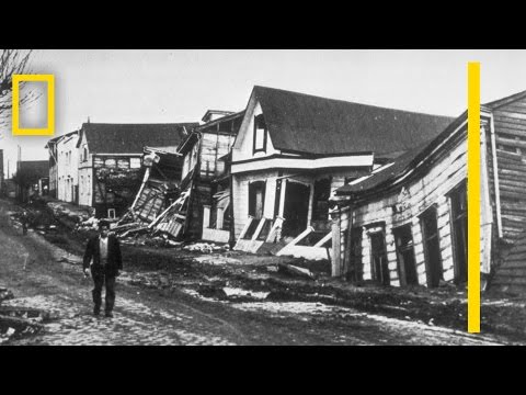
The earthquake’s epicenter was near Valdivia, a city in southern Chile, which bore the brunt of the destruction. Casualties were severe, with estimates of thousands dead and many more injured.
Global Impact and Resulting Tsunamis
The earthquake generated powerful tsunamis that affected coastlines far beyond Chile. Waves reached heights of up to 25 meters and traveled across the Pacific Ocean.
Areas like Hilo, Hawaii, and the coastlines of Japan and the Philippines experienced significant flooding and damage.
In addition, the tsunamis reached New Zealand and caused destruction in various coastal cities around the Pacific. The waves led to casualties and property damage in these regions, highlighting the far-reaching effects of the quake. It was a stark reminder of how localized seismic events could have global repercussions.
Aftermath and Reconstruction Efforts
The aftermath of the earthquake was catastrophic. Thousands were left homeless, and infrastructure was severely damaged.
In Valdivia, entire neighborhoods were destroyed, necessitating extensive reconstruction efforts.
Rebuilding efforts took years and required significant financial resources. The Chilean government, along with international aid, focused on restoring infrastructure like roads, schools, and hospitals.
Challenges included landslides and ongoing seismic threats, which complicated recovery efforts. Communities worked to rebuild not only their homes but also their spirits in the face of such destruction.
Understanding Earthquakes: Mechanisms and Global Seismicity

Earthquakes occur due to the movement of tectonic plates, which are large slabs of the Earth’s crust. These movements can result in various types of earthquakes, particularly in regions like the Ring of Fire.
This section explores how earthquakes develop and looks at significant historical events that shaped our understanding of seismic activity.
Tectonic Settings and Earthquake Genesis
Tectonic plates interact at their boundaries, causing earthquakes. There are three main plate boundaries: convergent, divergent, and transform.
At convergent boundaries, where, for example, the Nazca Plate collides with the South American Plate, megathrust earthquakes can occur. These powerful earthquakes can have magnitudes over 9.0, such as the Great Chilean Earthquake of 1960.
In divergent boundaries, plates move apart. This movement can create smaller earthquakes. Transform boundaries, like the San Andreas Fault in California, also result in significant seismic activity.
The U.S. Geological Survey monitors earthquakes and helps identify patterns and risks associated with these tectonic movements. Understanding these settings is crucial for predicting seismic events.
Historical Earthquakes and Their Lasting Lessons
Historical earthquakes provide valuable insights into earthquake behavior and community preparedness.
The San Francisco earthquake of 1906 offers lessons on building resilience in urban areas. This quake highlighted the need for strict building codes in earthquake-prone regions.
The Tohoku earthquake in Japan, which struck in 2011, showcased the devastating effects of large seismic events. Its repercussions extended beyond immediate damage, triggering a tsunami and a nuclear disaster.
These events underline the importance of earthquake preparedness and response.
Studying past earthquakes allows scientists to better understand earthquake magnitude and frequency, ultimately helping communities reduce risks and enhance safety.