Cyclones pose significant threats, especially during hurricane season, making it crucial for mariners to stay informed and prepared.
The 1-2-3 rule is a well-known guideline that helps those at sea avoid the danger zones of tropical storms and hurricanes.
This rule suggests that vessels maintain a safe distance from a cyclone based on the forecasted path and wind radii, ensuring better safety and navigation during extreme weather events.
Developed by meteorologists and used by the National Hurricane Center, the 1-2-3 rule uses data on the maximum winds of a storm.
Mariners draw circles around the storm’s position to determine safe distances. This strategy is vital in tracking hurricanes and navigating through unpredictable weather patterns.
Understanding the 1-2-3 rule allows mariners to take proactive measures to ensure their safety and that of their crew.
By following this guideline, they can effectively navigate around hurricanes and tropical storms, reducing the risk of encounters with severe weather.
Understanding the 1-2-3 Rule

The 1-2-3 rule is an important framework for mariners to assess their safety during tropical cyclones. It involves calculating potential danger zones based on wind speeds and forecast positions of a cyclone to prevent collisions or damage at sea.
Origins and Relevance of the Mariner’s 1-2-3 Rule
The Mariner’s 1-2-3 rule originated to help sailors navigate safely near tropical cyclones.
This rule assists in calculating the danger area by factoring in the 34-knot wind radius and forecast track errors.
By analyzing the past forecast track errors from agencies like the National Hurricane Center (NHC), mariners can create safer navigation plans.
The rule is critical for tropical cyclone avoidance as it provides structured guidance on maintaining distance from storms.
It is especially relevant during periods of rapid intensification, where a cyclone can grow stronger quickly and alter its path unpredictably.
Components and Calculation of the Danger Zone
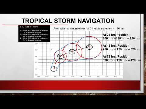
To apply the 1-2-3 rule, mariners must identify key elements: maximum radius, wind fields, and forecast positions at 24, 48, and 72 hours.
They start by drawing a circle around the cyclone’s center using the maximum radius of the 34-knot wind field. This radius encompasses the forecast positions over time.
Next, they add standard distances: 100 nautical miles for 24 hours, 200 nautical miles for 48 hours, and 300 nautical miles for 72 hours.
By analyzing these adjustments, sailors effectively create the danger zone, ensuring their ship maneuverability stays intact while navigating unpredictable weather patterns.
Practical Application for Mariners and Vessels at Sea
For mariners, applying the 1-2-3 rule is crucial when operating near tropical storms. This method aids in understanding how forecast uncertainty might affect a vessel’s route.
It assists in determining the distance to keep from the cyclone’s path, which improves decision-making during emergencies.
Mariners should monitor the tropical cyclone danger graphic provided by the NHC and adjust plans accordingly.
By taking wind speed and forecast errors into account, sailors can better predict potential threats and maneuver safely.
These practical steps enhance safety at sea, especially when facing sudden accelerations or hazardous conditions from a nearby cyclone.
Meteorological Aspects and Forecasting

Understanding the forecast process for tropical cyclones involves several crucial elements. This includes the role of the National Hurricane Center and their methods for predicting storm behavior, as well as the inherent tracking errors that can occur during the forecasting of wind fields.
Role of the National Hurricane Center and NOAA
The National Hurricane Center (NHC) and the National Oceanic and Atmospheric Administration (NOAA) play vital roles in monitoring and forecasting tropical cyclones in the Atlantic and East Pacific oceans.
They provide regular updates through tropical cyclone advisories that detail storm intensity, forecast track, and wind radii. Their data helps mariners and coastal residents understand where hurricane avoidance measures are necessary.
The NHC utilizes satellite imagery and advanced computer models to refine their predictions.
These methods track the growth and movement of tropical storms and hurricanes, allowing them to provide timely information that can save lives and property. Critical details such as the radius of 34-knot winds are included in advisories to inform those at risk Wind – ChaseDay.com.
Forecasting Track Errors and Wind Field Behavior
Forecast track errors refer to the differences between predicted and actual storm paths, which can impact safety measures. These errors can arise from unpredictable shifts in weather patterns or inaccuracies in data models.
The NHC outlines typical error margins for different forecasting periods, such as 24, 48, and 72 hours.
Wind field behavior is another essential aspect of forecasting. Understanding how winds circulate around a tropical cyclone helps assess potential damage zones.
Cyclones often expand their wind radii as they intensify, making early warnings critical. By analyzing historical data and current trends, meteorologists strive to minimize forecast track errors and enhance public safety when tropical systems approach coastal areas.

