
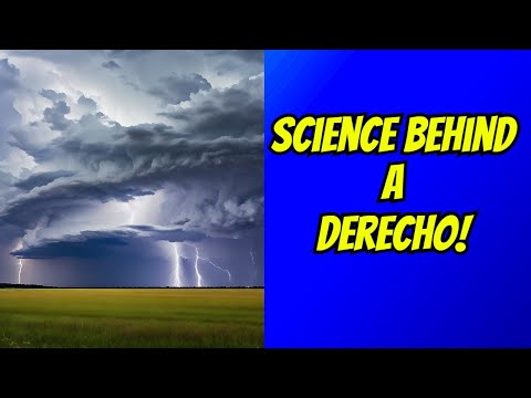
Derechos and squall lines are two important weather phenomena that can create severe weather, but they are distinct in their nature and impact.
A squall line is a line of thunderstorms that can produce heavy rain and strong winds, while a derecho is a specific type of squall line that brings widespread damage along its long path.
Understanding these differences is essential for those who want to stay informed about severe weather events.
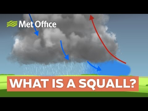
When thunderstorms organize into a squall line, they create a series of storm systems that can deliver intense rainfall and gusty winds. These squall lines usually develop ahead of advancing weather fronts and can lead to brief flash flooding and damaging winds.
In contrast, a derecho is characterized by sustained wind damage that spans at least 250 miles and often features wind gusts exceeding 100 mph.
Knowing these distinctions can help in recognizing the potential dangers of severe weather.
For weather enthusiasts and everyday citizens alike, it’s crucial to stay alert to these phenomena.
Keeping informed about various types of severe weather, including derechos and squall lines, aids in readiness and safety.
For more details on different severe weather types, visit articles on atmospheric phenomena.
Distinct Characteristics of Derechos and Squall Lines
Derechos and squall lines are both significant weather phenomena. They produce powerful winds and storms, but they have distinct features and behaviors that set them apart.
Definition and Nature
A squall line is a series of thunderstorms arranged in a line. These storms often bring heavy rain and strong gusts of wind, typically occurring along a cold front.
In contrast, a derecho is a specific type of squall line known for its intense and damaging straight-line winds. To be classified as a derecho, it must produce a wind swath of at least 250 miles, causing widespread damage along its path. Derechos are recognized for their sustained winds, while squall lines are more about the bursts of gusts and rain.
Formation and Development
Squall lines develop ahead of a cold front. They often form due to a gust front, which occurs when cold air from a thunderstorm pushes ahead of the storm, triggering new storms.
Conversely, derechos usually originate from a mesoscale convective system (MCS) and exhibit a bow echo shape on radar. This formation occurs when winds push the storm system forward at high speed, creating a bow-like structure. This characteristic is crucial as it indicates where the highest wind gusts will likely occur, often leading to severe weather alerts.
Impact and Damage
The impact of both phenomena can be significant.
Squall lines tend to cause localized wind damage, heavy rainfall, and lightning. They typically move quickly, leaving behind a narrow path of destruction.
In contrast, the wind damage from a derecho can be extensive, with straight-line winds exceeding 60 mph, sometimes reaching up to 100 mph. These intense gusts result from downbursts—sudden downward currents of air that can occur in severe thunderstorms.
The damage from derechos can lead to fallen trees, destruction of buildings, and widespread power outages. Awareness of these differences is crucial for weather safety and preparedness, especially in severe weather conditions.
For more information on weather phenomena, including wind-related events, resources are available on various platforms discussing the effects of wind.
Scientific Measurement and Prediction
Measuring and predicting severe weather events like derechos and squall lines relies on advanced tools and systems.
Accurate observation and timely forecasting are essential for ensuring public safety.
Observation Tools and Techniques
Meteorologists use various tools to observe weather patterns, with Doppler radar being a key component. This technology detects motion within storms by measuring the frequency shift of radar waves. It helps identify rotation, wind shear, and the intensity of precipitation.
Other observation tools include weather satellites, which provide a broader view of storm systems, and surface weather stations that track local conditions like temperature and humidity.
These observations help meteorologists understand the evolution of thunderstorms, including the formation of gust fronts and the development of severe weather phenomena.
Lightning detectors are also crucial, as they provide real-time data on lightning strikes, often associated with intense thunderstorms.
Using this combination of tools, meteorologists assess conditions that lead to derechos or squall lines and improve their understanding of these weather events.
Forecasting and Warning Systems
The National Weather Service (NWS) plays a vital role in forecasting storms and issuing warnings. They analyze data from observation tools to create models predicting the development of severe weather.
Meteorologists assess factors such as wind shear and atmospheric instability to forecast the potential for derechos.
Forecasting involves using computer models that simulate weather conditions. The NWS frequently updates forecasts based on new data, ensuring that the public receives timely warnings about dangerous weather.
When conditions are favorable for severe storms, the NWS issues alerts like Severe Thunderstorm Warnings.
Public awareness is crucial. Meteorologists often communicate through multiple channels, including social media and local news, to keep communities informed.
This proactive approach helps to mitigate risks associated with severe weather, including heavy rain, hail, and strong winds.