
Thunderstorms can create a variety of weather phenomena that impact both daily life and severe weather events. Among these, two terms often come up: squall lines and gust fronts.
A squall line is a long line of thunderstorms typically associated with severe weather, while a gust front is the leading edge of cold air that pushes out from a thunderstorm.
Understanding these differences helps in recognizing how they influence weather patterns.
A squall line can last for hours and produce intense weather conditions, including strong winds, hail, and even tornadoes. These lines of storms generally move in a direction, affecting an area significantly.
In contrast, the gust front acts more as a boundary, where cold air clashes with warmer, moist air, which can lead to the development of new thunderstorms. Such atmospheric phenomena are crucial to monitor, especially during severe weather events.
Recognizing the distinction between a squall line and a gust front can enhance safety during storms. Individuals tracking thunderstorms may find it valuable to understand how these components interact to bring extreme weather. For more insights on related weather topics, articles on atmospheric phenomena can help shed light on these fascinating systems.
Understanding Squall Lines
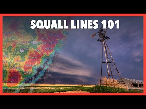
Squall lines are significant weather phenomena characterized by a series of thunderstorms. They can produce severe weather, including damaging winds and heavy rain.
Formation and Characteristics
A squall line forms when warm, moist air rises ahead of a cold front. This rising air creates thunderstorms, often with cumulonimbus clouds. These clouds can grow rapidly due to strong updrafts.
Wind shear, or changes in wind speed and direction with altitude, helps organize these storms into a line.
Typically, squall lines can stretch for hundreds of miles, with a width of only 10 to 20 miles. They often precede a cold front, producing intense rainfall and strong winds.
In some cases, squall lines may evolve into a mesoscale convective complex, further increasing their severity. Their structure can include features like a bow echo, which can indicate the potential for damaging winds.
Impact and Significance
The impact of squall lines can be severe. They often produce heavy rain, leading to flash floods. The damaging winds can exceed 58 mph, causing destruction to trees and structures. In some situations, squall lines can spawn tornadoes, though this is less common.
Understanding squall lines is vital for severe weather forecasting. They are different from individual thunderstorms but can still result in significant weather events. Awareness of these phenomena helps prepare communities for adverse conditions, especially during electrical storms. For more on electrical storms, visit articles on related topics.
Examining Gust Fronts

Gust fronts play a crucial role in weather dynamics, particularly during severe thunderstorms and wind storms. Understanding their behavior and prediction can help in storm forecasting and safety measures.
Dynamics of Gust Fronts
A gust front forms when cold air from downdrafts pushes out and collides with warmer surface air. This interaction creates a sudden increase in wind speed, known as wind gusts. These gusts can be intense and last for short periods, often linked to downbursts or severe thunderstorms.
Gust fronts can also lead to features like shelf clouds, which appear as a low, horizontal cloud base at the leading edge. These are often visible on radar reflectivity, indicating strong winds associated with the front. The movement of the gust front is influenced by the wind direction and temperature of the surrounding air masses, making them an essential focus for meteorologists at the Storm Prediction Center.
Observation and Prediction
Monitoring and predicting gust fronts involves analyzing weather radar and surface observations.
Meteorologists utilize radar reflectivity to identify the strength and movement of gust fronts. The presence of a mesoscale convective vortex (MCV) can enhance the longevity of gust fronts, complicating predictions.
Effective detection of gust fronts is key to issuing timely warnings for severe weather.
The National Oceanic and Atmospheric Administration (NOAA) provides guidelines to improve forecasting methods, helping communities prepare for potential impacts.
Accurate observation methods allow for better understanding and forecasting of wind patterns and potential damage from downbursts.
Initiatives to analyze surface movement further enhance prediction accuracy, making this data critical in severe weather scenarios.