
Lake-effect snow and regular snow are both forms of winter precipitation, but they form through different processes.
Lake-effect snow occurs when cold air moves over warmer water, picking up moisture and depositing it as heavy snow on nearby land.
In contrast, regular snow typically forms from larger weather systems, like low-pressure systems that cool moist air and release it as snow over a broader area.
For people living in areas near large bodies of water, especially the Great Lakes, understanding lake-effect snow is crucial. These snow bands can create intense snowfall in localized areas, leading to drastically different weather conditions just a few miles apart.
While regular snow may blanket a region evenly, lake-effect snow can result in narrow bands of heavy accumulation, impacting travel and daily life in unique ways.
Meteorologists closely monitor these phenomena, especially during winter months when snowstorms can occur. Knowing the differences between lake-effect snow and regular snow helps communities prepare for the challenges each type of storm can bring.
Understanding Lake-Effect Snow
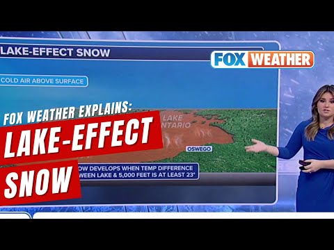
Lake-effect snow is a unique weather phenomenon primarily affecting areas near large bodies of water, like the Great Lakes. This type of snow occurs when cold air moves over warmer waters, leading to intense and localized snowfall. Several key factors influence its formation and characteristics.
Formation of Lake-Effect Snow
Lake-effect snow forms when a cold air mass travels over relatively warm waters, typically from the Great Lakes. The temperature difference causes the air to warm and pick up moisture.
When this moist air moves inland, it cools, which leads to precipitation in the form of snow.
Wind direction plays a vital role in this process. If the wind flows across the lake and towards land, it can enhance snowfall rates significantly. Lake-enhanced snow occurs when this moisture contributes to broader snow showers. Understanding these dynamics helps in forecasting snow events.
Characteristics of Lake-Effect Snow
Lake-effect snow is known for creating narrow bands of intense snowfall. These bands can be as wide as a few hundred feet but can stretch for miles.
As a result, drivers may enter a heavy snow zone suddenly, experiencing near-whiteout conditions.
Storms can produce varying snowfall rates, with some areas receiving inches of snow per hour. The conditions can become dangerous quickly, especially in regions like Western New York. These snow events can lead to hazardous travel and increased snowfall totals.
Regional Impact and Forecasting
The Great Lakes region is particularly prone to lake-effect snow due to its geography. The National Weather Service plays a critical role in forecasting these weather patterns.
Accurate predictions rely on understanding wind direction and temperature differences, which are essential for anticipating where and when heavy snowfall will occur.
Forecasting involves monitoring environmental factors, including lake temperatures and cold air masses from Canada.
Awareness of these conditions helps communities prepare and respond swiftly, reducing risks associated with dangerous conditions. Advanced technology has improved the ability to track these events and inform the public effectively.
Comparing Lake-Effect Snow to Regular Snow

Lake-effect snow and regular snow differ significantly in their formation and snowfall patterns. Understanding these differences helps in grasping the impact of each type on weather conditions.
Mechanisms Behind Regular Snow
Regular snow typically forms when moist air rises in the atmosphere, often influenced by a cold front or low-pressure system. As the moist air cools, it condenses into clouds, leading to widespread snow events.
These occurrences often happen during winter months, particularly in late fall.
When enough moisture gathers in clouds, snowfall occurs. This can result in several inches of snow per hour during intense snowstorms. Regular snow often blankets a large area evenly, covering roads and landscapes with a consistent layer.
Differences in Snowfall Patterns
In contrast, lake-effect snow arises when cold air travels over warm lake waters, particularly near the Great Lakes. This process leads to localized bands of heavy snow.
The temperature difference causes the cold air to pick up moisture, forming distinct snow bands that can result in intense snowfall over short distances.
While regular snow can cover a wide area uniformly, lake-effect snow can create sharp snow gradients. Areas just a mile apart may see significantly different totals, sometimes exceeding two feet where snow bands set up.
This variability is crucial for forecasting.
For additional details on winter weather, refer to articles on snow and ice.