
The leading edge of a squall line is a crucial area that indicates the onset of severe weather, particularly thunderstorms. This edge is characterized by intense winds and rapidly rising air that can lead to heavy rainfall, hail, and even tornadoes.
Meteorologists closely monitor these systems to provide timely warnings to communities at risk.
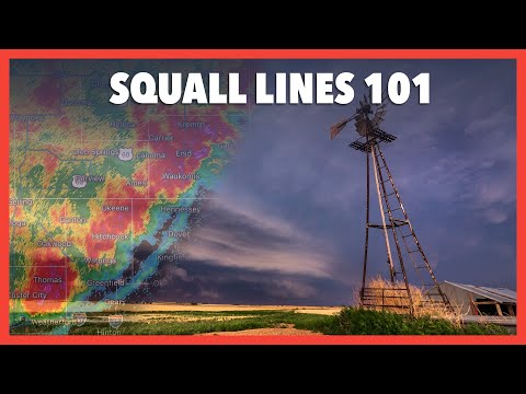
Squall lines form when warm, moist air is lifted rapidly over a cooler surface, creating conditions ripe for severe thunderstorms. As these lines move, the leading edge, often called the gust front, brings noticeable changes in weather.
Residents in areas prone to extreme weather should pay attention to forecasts that discuss squall lines, as they are often accompanied by dangerous conditions.
Understanding the dynamics of squall lines can help people prepare for sudden weather changes. For those interested in atmospheric phenomena, delving deeper into this topic can reveal how these storms develop and what impacts they can have. Exploring resources on severe weather can enhance awareness and readiness when such storms approach.
Characteristics of Squall Lines

Squall lines are complex weather phenomena with distinct features. They typically form along or ahead of cold fronts, leading to severe weather conditions.
Understanding their formation and types is crucial for predicting their impact.
Formation and Structure
Squall lines form when warm, moist air meets cold, dry air, usually along a cold front. This interaction creates instability in the atmosphere.
As the warm air rises, it cools and condenses, leading to the development of thunderstorms.
The leading edge of a squall line is known as the gust front, where strong winds are present. Behind this, the storms often exhibit heavier precipitation and stronger wind shear.
Additionally, a squall line may generate features like shelf clouds, which appear as a low-lying cloud formation at the leading edge.
A mature squall line can also develop into a bow echo. This formation creates a bow-shaped curve in radar images and is associated with damaging winds.
These systems are classified under the broader category of mesoscale convective systems, which are essential in understanding severe weather patterns.
Types of Squall Lines
Squall lines can be categorized based on their structure and intensity. The most common types include linear squall lines and supercell-derived squall lines.
Linear squall lines generally appear as long, narrow bands of thunderstorms. They are often associated with continuous severe weather, like heavy rain and strong winds.
In contrast, supercell-derived squall lines occur when a supercell storm produces new storms along its outflow boundary or gust front.
This type can lead to increased tornado activity due to enhanced rotational dynamics.
Both squall line types pose significant risks, such as flash flooding and straight-line wind damage. Thus, awareness of these characteristics is vital for weather safety.
Squall Line Dynamics and Impacts
Squall lines are complex weather systems that can lead to severe weather events. Understanding their dynamics helps in predicting the associated phenomena and preparing for the impacts they can have on the environment and communities.
Associated Weather Phenomena
Squall lines often bring various severe weather events. They can produce hail, which varies in size and can cause damage to property and crops.
Tornadoes can also develop within or near these systems, especially when wind shear is significant.
Derechos, which are widespread, long-lived windstorms, may occur alongside squall lines. These storms can lead to damaging winds that cause extensive damage to trees, power lines, and buildings.
Heavy rain is another common occurrence, contributing to flash flooding in vulnerable areas.
Lightning is frequent in these storms, making outdoor activities dangerous.
The National Weather Service closely monitors squall lines to issue timely warnings for these severe weather conditions.
Detection and Forecasting
Detecting squall lines is crucial for timely weather alerts.
Forecasters use Doppler radar to track the formation and movement of these systems. This technology helps in identifying the intensity of storms and potential hazards.
Meteorologists pay attention to features such as bow echoes, which indicate strong winds. By recognizing these patterns, the risk of severe weather, including downbursts and tornadoes, can be assessed.
Forecasting models also analyze environmental factors, like temperature and humidity, that contribute to squall line development. Awareness of these elements allows for better predictions.
Continuous monitoring of these systems ensures the public is informed about potential threats, enhancing safety during severe weather events. For more details on related weather phenomena, check out information on electrical storms.