
When it comes to severe weather, understanding the types of thunderstorms is crucial.
The most powerful type of thunderstorm is the supercell. These storms are known for their intense strength and longevity, often lasting for hours. A supercell features a rotating updraft called a mesocyclone, which can lead to severe consequences, including large hail, tornadoes, and extreme winds.

Supercells are less common than other types of thunderstorms, but they are responsible for a significant portion of intense weather events in many regions.
In the United States, these storms frequently occur in the Midwest and South, where the conditions are ripe for severe weather. The potential for damaging outcomes makes studying these storms essential for meteorologists.
Understanding supercells and their behavior can help prepare for severe weather. By recognizing what sets them apart from other thunderstorm types, individuals can stay informed and enhance their safety during extreme weather events.
Keeping an eye on surface movement can also provide valuable insights into storm development and intensity.
Characteristics of Supercell Thunderstorms
Supercell thunderstorms are distinct from other storm types due to their unique structure and lifecycle. They can produce severe weather, including strong winds, hail, and tornadoes. Understanding their characteristics helps in predicting and responding to these dangerous storms.
Formation and Structure
Supercells form when strong vertical wind shear is present. This means that winds in the atmosphere change speed and direction with height.
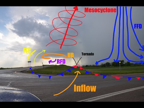
A supercell has a rotating updraft called a mesocyclone. This updraft helps to create a tall and organized storm structure, typically classified as a cumulonimbus cloud.
The storm features a wall cloud at its base, which is where rotation is most noticeable. The presence of downdrafts can lead to severe weather as the cold air sinks, often resulting in a downburst. These storms can exist for hours due to their strong internal organization.
Stages of a Supercell
Supercells usually progress through three stages: the cumulus stage, mature stage, and dissipating stage.
-
Cumulus Stage: This initial stage starts with the development of cumulus clouds. Updrafts dominate the storm, and the system is relatively weak.
-
Mature Stage: During this stage, the storm reaches its peak intensity. Heavy rain and frequent lightning occur, often accompanied by large hail. Additionally, tornadoes may form during this phase.
-
Dissipating Stage: Finally, the storm starts to weaken. Downdrafts become dominant, leading to less severe weather. Despite this, flash flooding can still occur due to heavy rain.
Associated Weather Phenomena
Supercells are known for producing various severe weather phenomena. Large hail and strong winds are common outcomes. The intense updrafts can create significant hailstones capable of causing property damage.
Furthermore, supercells are also a common source of tornadoes. The rotation within a mesocyclone can tighten and extend downward, forming these dangerous storms. Lightning is frequent and can trigger wildfires or electrical hazards.
The potential for flash flooding exists due to the prolonged rainfall associated with these storms. Understanding these characteristics is essential for effective storm tracking and public safety measures.
The Impact of Supercell Thunderstorms
Supercell thunderstorms are powerful and complex systems that can cause significant damage. Their unique features, such as rotating updrafts, lead to severe weather events. Understanding their impact is important for safety and preparedness.
Safety and Preparedness
Supercells can create extreme conditions, including flash floods, high winds, and large hail.
Wind shear, the change in speed and direction of winds at different heights, plays a major role in supercell development. This can lead to tornadic activity and chaos in communities.
Preparedness is key in areas prone to severe thunderstorms.
Individuals should stay informed with alerts like a thunderstorm watch, indicating conditions favoring storm development. A thunderstorm warning signals that severe weather is occurring, prompting immediate action.
It’s crucial to have plans in place for potential catastrophic flooding.
People can protect themselves by securing their homes and having emergency kits ready. Knowing how to respond to severe weather can greatly reduce risks, especially in vulnerable regions.
More information about safety during these events can be found by following reliable resources, such as those focusing on water-related issues.