
As winter unfolds in 2024, many are curious about the polar vortex and its influence on weather patterns.
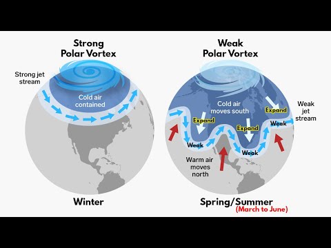
The polar vortex is a large area of low pressure and cold air surrounding the Earth’s poles, which can greatly affect winter temperatures. When the vortex is strong, it keeps the cold air contained, but when it weakens, Arctic air can spill into lower latitudes, leading to colder conditions in many regions.
This year, early data suggests that the polar vortex may be weaker than normal. This change could result in a more dynamic weather pattern, increasing the likelihood of colder temperatures and snow across the United States and parts of Europe.
Meteorologists are closely monitoring these developments, as shifts in the polar vortex can dramatically reshape winter experiences.
Understanding the polar vortex is essential for predicting how winter will unfold.
As cold air masses move south, they can lead to extreme cold snaps and unusual weather patterns.
With ongoing changes in atmospheric conditions, 2024 could be a notable year for winter weather enthusiasts and those simply looking to stay warm.
Mechanisms of the Polar Vortex
The polar vortex is a complex system influenced by various atmospheric dynamics.
Key aspects include stratospheric behavior, the effects of sudden stratospheric warming, and interactions with the jet stream and troposphere. Understanding these mechanisms is crucial for predicting how the polar vortex affects weather patterns.
Stratospheric Dynamics
The polar vortex exists in the stratosphere, typically around 10 to 30 miles above the North Pole. It is characterized by a band of strong winds that flow counter-clockwise. Wind speed is highest near the center, creating a barrier that keeps cold Arctic air contained.
As temperatures fluctuate, certain atmospheric phenomena can disrupt this flow.
Geopotential height changes indicate shifts in pressure and temperature that can either strengthen or weaken the vortex. Additionally, atmospheric waves can enhance or disrupt these dynamics, affecting the overall stability of the polar vortex.
Influence of Sudden Stratospheric Warming
Sudden stratospheric warming (SSW) plays a pivotal role in polar vortex behavior. This refers to a rapid increase in stratospheric temperatures, which can weaken the polar vortex significantly. When SSW events occur, they can lead to wind reversal, pushing cold Arctic air down towards lower latitudes.
During these events, the stability of the polar vortex can be compromised, leading to polar vortex disruptions. Such disruptions often result in severe winter weather across parts of North America and Europe. Understanding these warming events helps meteorologists predict extreme cold outbreaks and their associated impacts.
Jet Stream and Tropospheric Interactions
The polar vortex influences the jet stream, a fast-flowing air current in the troposphere.
When the polar vortex is stable, the jet stream tends to flow smoothly. Conversely, when the vortex weakens, the jet stream can become wavier, allowing frigid air to plunge southward.
This interaction can lead to significant weather changes. For instance, when the jet stream dips, it can bring colder temperatures and severe weather to mid-latitude regions.
The quasi-biennial oscillation, a pattern of stratospheric wind variation, also plays a role in affecting both the polar vortex and the jet stream. Enhanced understanding of these interactions is vital for weather forecasting and preparing for severe conditions.
Polar Vortex Impact on Winter 2024/2025

The polar vortex is expected to influence the winter of 2024/2025 in various significant ways. It will affect weather patterns across North America and Europe, leading to cold air outbreaks and potential extreme weather events. Understanding these impacts is essential for anticipating upcoming winter conditions.
Effects on North American Climate
In North America, the polar vortex is crucial for winter weather. During 2024/2025, forecast data suggests a weaker polar vortex which can lead to more cold air outbreaks.
A low-pressure area near the northeastern U.S. can cause frigid air to spill southward.
The influences of El Niño and La Niña may also play a role. These phenomena impact winter circulation and can alter temperature and precipitation forecasts.
The position of high-pressure systems above the West Coast could block the cold air, creating a persistent cold phase in some areas. These dynamics suggest varied snowfall potential across regions, with the northeast facing increased chances of thundersnow events.
Consequences for Europe
Winter in Europe will also feel the effects of the polar vortex. A weaker vortex may persist for longer periods, allowing more cold air from the North Pole to reach southern regions.
This shift can create more precipitation and snow across central and western Europe.
Countries like the UK and Germany may experience harsher winter conditions. The extent of snowfall will depend on the interaction between cold air masses and moist air, which may lead to significant snowfall forecasts in certain areas.
Close attention will be needed on how these pressures affect surface temperature across Europe.
Cold Air Outbreaks and Extreme Events
Cold air outbreaks will be a prominent feature of winter 2024/2025. The movement of the polar vortex can trigger sharp temperature declines, resulting in frigid air reaching much farther south than usual.
These outbreaks may lead to extreme weather conditions.
The blocking patterns created by the polar vortex’s winds could enhance the chances of extreme events, like heavy snowstorms.
The balance of high and low-pressure systems will determine whether these events bring more than just cold temperatures, leading to significant weather phenomena.
Monitoring the snow and ice conditions will be essential as the season progresses, particularly in regions unaccustomed to severe winter weather.