
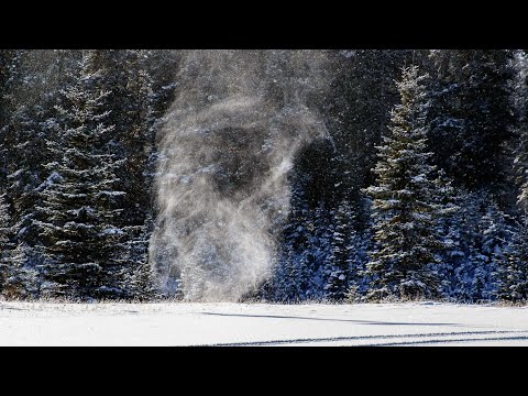
The snow devil is a captivating weather phenomenon that many may have seen in videos or heard about but few fully understand. These rare occurrences are essentially whirling columns of snow that form when dry snow is lifted by strong winds, creating a mesmerizing display in winter landscapes. Although often referred to as “snownadoes,” snow devils can surprise onlookers with their beauty and unpredictability.
As a meteorologist with decades of experience, he emphasizes that snow devils are not only visually striking but also intriguing scientific events. They can arise under specific conditions where warm air meets cold air, leading to the swirling motions that define this phenomenon.
Spotting a snow devil is a special experience, making it a memorable highlight for winter sports enthusiasts and nature lovers alike.
Understanding the dynamics behind snow devils adds to their allure. These whirling columns represent the fascinating interplay of weather patterns and can often catch those who witness them off guard.
Exploring snow devils reveals just how remarkable and diverse winter weather can be, inviting readers to learn more about this unique aspect of our natural world.
Formation and Characteristics of Snow Devils
Snow devils, also known as snownadoes, arise under specific weather conditions. Understanding their formation and physical attributes reveals why they are rare winter phenomena.
Mechanism of Formation
Snow devils form when dry snow is lifted by strong gusts of wind. This lifting process creates a spinning vortex, similar to that of a tornado.
The cool air above moves over a warmer surface, causing differences in air temperature. When surface wind shear is strong enough, it generates the whirling column of snow particles.
The vertical movement of air is crucial. As the snow is picked up, it combines with the wind’s rotational force, enhancing the vortex’s strength.
Only under precise conditions, such as low humidity and optimal temperature differences, do snow devils develop. They are not common, with very few captured on camera, which adds to their intrigue.
Physical Attributes
A snow devil appears as a narrow, rotating column of snow that can vary in height. These whirling columns can reach several meters into the air. The diameter is usually small, often just a few meters, but they can be surprisingly tall.
These phenomena can be visually striking, resembling a miniature tornado of snow particles. They move quickly across the ground, influenced by wind direction. This fast movement contributes to their transient nature.
Snow devils are a fascinating part of the winter landscape but can be difficult to observe due to their rarity and specific formation conditions.
For further details on wind effects, see articles about wind.
Observations and Impact
Snow devils are a rare phenomenon that captures the attention of meteorologists and weather enthusiasts alike. Their formation and behavior provide insights into specific weather patterns and atmospheric conditions. Both documented cases and their meteorological significance highlight the unique characteristics of snow devils.
Documented Cases
Instances of snow devils have been reported with increasing frequency, especially in regions like Idaho. One notable case occurred at Fish Creek Summit, where a snow devil was recorded using a GoPro camera by a passerby.
The video captured the swirling vortex of snow, showcasing its ability to lift and move particles high into the air. Such documented events are important as they contribute to understanding how these phenomena operate in real-time.
The World Meteorological Organization notes that conditions for forming snow devils require specific weather patterns, including surface wind shear over snow cover. This delicate balance is often present during cold, dry conditions.
Various online videos document similar occurrences, emphasizing that snow devils, although rare, can still be observed under the right atmospheric circumstances.
Meteorological Significance
The presence of snow devils offers valuable insights into local weather patterns. They often form when warm air interacts with cold surfaces, creating a vortex effect similar to dust devils in warmer climates.
Understanding these interactions helps meteorologists grasp the dynamics at play in the atmosphere.
These mini tornado-like formations can indicate underlying atmospheric conditions that may lead to larger weather events. Snow devils serve as tangible indicators of localized wind patterns and can enhance knowledge of how snow cover influences surface winds.
As meteorologists study these impacts, they gain a more comprehensive picture of winter weather phenomena, benefiting forecasting accuracy in affected areas.