
Nor’easters are powerful storms that can bring heavy snow, strong winds, and coastal flooding.
Meteorologists rely on advanced technology to monitor these complex weather events and make accurate weather predictions. Some of the key tools they use include Doppler radar, satellite imagery, and weather buoys, which help them track atmospheric conditions in real-time.
By analyzing data from these tools, meteorologists can better understand the development and movement of nor’easters. This information allows them to provide timely forecasts, which are crucial for keeping the public informed and safe during severe weather.
High-resolution computer models also play a vital role, simulating various scenarios and enhancing the accuracy of weather forecasting.
As storms approach, meteorologists pay close attention to changes in temperature, pressure, and humidity. These factors influence the storm’s path and intensity, making accurate monitoring essential.
The combination of traditional methods and cutting-edge technology enables meteorologists to provide critical updates and warnings, helping communities prepare for the impact of nor’easters.
Weather Observation Technologies
Meteorologists rely on a variety of advanced technologies to monitor weather patterns, especially during significant events like nor’easters. These technologies enhance the ability to observe atmospheric conditions and predict storm development with greater accuracy.
Remote Sensing Instruments
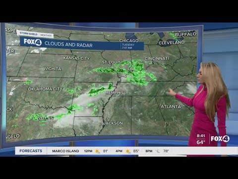
Remote sensing instruments play a crucial role in weather observation. Satellites offer comprehensive views of cloud cover and storm systems across vast areas. They capture satellite imagery that helps meteorologists assess conditions in real-time.
Doppler radar is another essential tool. It can detect precipitation, wind speed, and direction, providing vital data for forecasting. These radar systems allow for tracking storm development and intensity. Advanced weather models utilize this data to project future weather patterns.
This technology aids in climate research, helping scientists understand atmospheric phenomena and variations. Comprehensive data from these instruments ensures accurate and timely information to the public.
Upper-Air Weather Monitoring
Monitoring upper-air data is essential for understanding atmospheric conditions above the surface. Weather balloons, equipped with radiosondes, are used to collect information on temperature, humidity, and atmospheric pressure at different altitudes.
This information is critical for predicting how storms will evolve. As winds aloft greatly affect storm behavior, knowing their speed and direction is crucial.
Meteorologists analyze this data alongside surface observations to refine forecasts. Using computer models, they simulate how these upper-air conditions interact with surface weather, helping improve short-term and long-term predictions.
Understanding these dynamics is vital for decision-making during severe weather events. Accurate upper-air monitoring supports effective community preparedness, particularly for systems like nor’easters that can impact many people.
Ground-Based Instrumentation
Ground-based instrumentation plays a crucial role in monitoring nor’easters. These tools collect essential data on atmospheric conditions. Through specific measurements, meteorologists can better understand weather patterns and improve forecasting accuracy.
In-Situ Measurement Devices
In-situ measurement devices are vital for collecting real-time data. Thermometers measure air temperature, while anemometers assess wind speed. These measurements help evaluate the intensity of nor’easters.
Devices like hygrometers determine relative humidity, providing insight into moisture levels in the atmosphere. Barometers gauge air pressure, which is crucial for identifying storm systems.
Automated weather stations often integrate these instruments, allowing for continuous data collection across various locations.
Rain gauges measure liquid precipitation, essential for assessing snowfall and rain during a nor’easter. This data helps meteorologists understand potential flooding risks and other severe weather threats. Continuous monitoring of these factors is key to effective forecasting and ensuring public safety.
Data Synthesis and Forecasting
The synthesis of data from various ground-based instruments allows for accurate weather forecasting.
Meteorologists input measurements from thermometers, anemometers, and rain gauges into computer models. These models simulate weather patterns, enabling them to predict future conditions.
Weather patterns can shift rapidly during nor’easters, making accurate forecasts critical.
Analyzing the data enables meteorologists to make timely warnings about severe weather impacts. The National Weather Service relies on this information to communicate risks to the public, helping communities prepare for potential storms.
By integrating diverse data sources, meteorologists can optimize their forecasting strategies.
This approach not only helps predict the weather but also enhances public safety before and during intense storms. For example, a clear understanding of temperature, wind, and precipitation aids in anticipating a storm’s evolution.