Tornadoes are fascinating yet destructive natural events that occur under specific conditions.
For a tornado to form, two key types of air masses are necessary: warm, moist air and cold, dry air. The interaction between these two masses creates an unstable atmosphere, ideal for tornado formation.
Warm, moist air rises quickly, while cold, dry air moves in a different direction. This contrasting movement can lead to the development of severe thunderstorms, particularly supercells, which are known for producing the most dangerous tornadoes.
Understanding the basics of tornado formation can help in recognizing the signs of severe weather and preparing for potential impacts. Learning more about atmospheric phenomena can provide deeper insights into these extreme weather events.
As we explore the specifics of air masses and their role in tornadoes, readers will gain valuable knowledge about how these powerful storms develop and the conditions that fuel them. Tornadoes represent both a meteorological marvel and a significant hazard, making it essential to understand what triggers their formation.
Air Masses and Their Role in Tornado Formation

Different types of air masses are essential for tornado formation. A tornado typically forms when warm air and cold air interact under certain weather conditions. Understanding these air masses provides insight into the severe weather phenomena experienced in areas like tornado alley.
Characteristics of Warm Air
Warm air plays a crucial role in tornado formation. Often originating from the Gulf of Mexico, this air is humid and light.
It rises easily, creating an upward movement necessary for thunderstorms. The warm air is also less dense compared to cold air.
As the warm, moist air rises, it can lead to the creation of supercells, which are powerful thunderstorms that can produce tornadoes. These conditions allow for the development of a rotating column of air. Warm winds fueling the rising air intensify the storm system, increasing the likelihood of severe weather.
Characteristics of Cold Air
Cold air is the counterpart to warm air during tornado formation. Typically, this air comes from polar regions and is characterized by its dryness and density.
When cold air moves into an area dominated by warm, moist air, it creates instability in the atmosphere. The denser cold air pushes underneath the warm air, leading to upward motion. This interaction is critical for forming strong thunderstorms. Cold air can also contribute to the wind shear needed for a tornado’s development by changing wind speed and direction at different altitudes.
The Impact of Wind Shear
Wind shear refers to the change in wind speed and direction with height. This phenomenon is crucial for tornado formation as it can create spinning air.
A significant difference in speed between upper and lower winds can lead to the development of a rotating column of air within a storm. When warm, moist air rises and meets cold air, wind shear can enhance the rotation.
This interaction is often observed in supercells, which have the potential to produce tornadoes. Areas with high wind shear are more prone to severe weather, where tornadoes may develop as conditions become favorable. Understanding wind shear is key for predicting tornado activity in regions at risk.
Path from Supercellular Thunderstorms to Tornado Development

Supercell thunderstorms play a crucial role in the formation of tornadoes. They generate the necessary conditions for tornado development through their unique structures and dynamics. This section explores how these storms evolve into tornado-producing systems.
Understanding Supercellular Structures
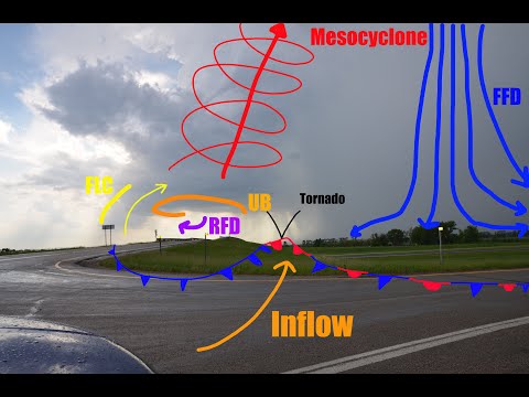
Supercell thunderstorms are highly organized weather systems characterized by a rotating updraft known as a mesocyclone. This rotation occurs due to strong wind shear, which is the change in wind speed and direction with height.
A supercell consists of three key parts: the updraft, downdraft, and anvil. The updraft is essential as it can extend high into the atmosphere, allowing for the development of severe thunderstorms. As warm, moist air rises, it cools and condenses, forming a condensation funnel that can develop into a funnel cloud.
Supercells are classified into rotating and non-rotating types. Rotating supercells are primarily responsible for tornado formation, making them more dangerous during the tornado season.
Tornado Formation Process
The tornado formation process begins within a supercell when wind patterns create a mesocyclone.
As the updraft strengthens, it begins to draw in more moisture and unstable air. This interaction can lead to a tornado watch being issued, alerting communities about the potential for tornadoes.
As the mesocyclone tightens, a funnel cloud may form. If this cloud reaches the ground, it becomes a tornado. The tornado’s intensity can vary, often assessed using the Enhanced Fujita Scale, which ranges from EF0 to EF5.
The conditions for tornado formation are not limited to supercells. Other events like landspouts and waterspouts also occur under different circumstances, resulting in various types of tornadoes.
Types of Tornadoes and Related Phenomena
Tornadoes can be classified into several types based on their formation conditions.
The common types include supercell tornadoes, landspouts, and waterspouts.
Supercell tornadoes are the most severe and form from rotating thunderstorms. These can produce significant damage and generally occur during warm months.
Landspouts form from non-supercell storms and are usually less intense. They can develop quickly and are often weak.
In contrast, waterspouts occur over water and can also lead to tornadoes if they move onto land.
The differences between these types showcase the complexity of tornado development and the importance of monitoring severe thunderstorms and issuing timely tornado warnings.
Tracking surface movement and changing conditions is vital for accurate forecasts.

