
Nor’easters and tropical storms are two types of intense weather systems that can significantly impact the East Coast of North America. The key difference between them lies in their formation and characteristics: nor’easters develop in cold conditions along the northeastern U.S. and are associated with winter weather, while tropical storms originate over warm ocean waters and bring heavy rains and strong winds.
Understanding these differences can help people prepare for the unique dangers each type of storm presents.
Nor’easters often arise from low-pressure systems that form along the coast, usually between October and April. They can bring heavy snow, rain, and strong winds, causing hazardous travel conditions and flooding.
In contrast, tropical storms typically develop in warmer months and can lead to powerful hurricanes if their intensity increases. These storms usually form over the Atlantic Ocean and can create severe weather far from their center.
As both nor’easters and tropical storms can lead to considerable impacts, knowing their differences can be crucial for preparedness. With the right information, individuals and communities can better respond to these weather events and stay safe during adverse conditions.
Understanding Nor’easters

Nor’easters are powerful storms that impact the East Coast, particularly New England. They can bring heavy snow, strong winds, and significant flooding. Understanding their formation, characteristics, and historical context helps people prepare for these winter storms.
Formation and Characteristics
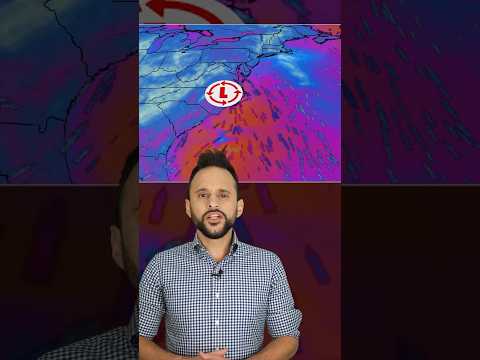
Nor’easters typically form along the East Coast where cold air from Canada meets warm, moist air from the Atlantic Ocean. This interaction creates a low-pressure system that can intensify, drawing in cold air and causing heavy rain, snow, or a mix of both.
The jet stream often plays a crucial role, guiding these storms along the coast. As a result, they usually occur between October and April.
When the storm strengthens, winds can reach a high intensity, contributing to blizzard conditions with heavy snow and reduced visibility. Storm surge is also a significant concern, especially in coastal areas. Flooding may occur due to a combination of high winds and heavy precipitation.
Impact on the East Coast
Nor’easters can cause widespread damage across the East Coast, especially in the I-95 corridor. These storms are known for their heavy rain, high winds, and snow, leading to disruption of daily life, travel, and commerce.
Significant coastal flooding can occur as a result of storm surge, particularly during high tides. With wind gusts sometimes exceeding 60 mph, power outages are common, and trees may fall, making roads impassable.
In New England, the heavy snow can lead to blizzards that bury neighborhoods. Communities need to prepare for prolonged disruptions, including road closures and emergency services challenges.
Historical Nor’easters
Throughout history, notable nor’easters have left their mark. The Blizzard of 1888 is one of the most infamous, shutting down cities and leading to significant loss of life. It demonstrated the potential severity of winter storms.
More recent storms have also made headlines, showcasing the risks associated with nor’easters. Each storm contributes to an understanding of winter weather patterns and impacts, aiding in future predictions.
Rising sea levels and changing weather patterns may influence the intensity and frequency of these storms. Understanding nor’easters remains critical for preparedness, particularly for regions along the coast.
For additional details on the effects of snow and ice, check out articles on Snow and Ice.
Understanding Tropical Storms
Tropical storms are significant weather events that form over warm ocean waters. They can develop into hurricanes under the right conditions. Understanding their formation, development, and impacts is essential for safety and preparedness, especially in coastal areas.
Formation and Characteristics
Tropical storms typically form in warm tropical regions. The sea surface temperature must be at least 26.5°C (about 80°F) to provide the necessary heat and moisture. These storms begin as tropical depressions, where wind speeds range from 0 to 38 mph.
When they reach wind speeds of 39 to 73 mph, they are classified as tropical storms.
The storms are characterized by strong winds, heavy rain, and a low-pressure center. Unlike nor’easters, tropical storms are warm-core systems. They develop from atmospheric disturbances combined with moist air and converging winds. Warm air rises, causing the pressure to drop and further enhancing wind speeds as they spiral around the storm center.
Tropical cyclones, which include tropical storms and hurricanes, can impact the Gulf of Mexico and the Atlantic Ocean significantly. The conditions that drive their formation include wind shear and the presence of tropical air.
Storm Development and Classification
Tropical storms undergo various stages of development. They can strengthen into a hurricane when they achieve sustained wind speeds of at least 74 mph. The National Hurricane Center (NHC) monitors these conditions closely during hurricane season, which runs from June to November.
The classification system for tropical cyclones involves several categories, each defined by wind speed. Category 1 storms have winds of 74-95 mph, while more intense storms can develop into Category 5 hurricanes, with winds exceeding 157 mph.
As they intensify, tropical storms can become destructive forces. They can cause rough seas, storm surge, and heavy rains. These factors contribute to the potential for coastal flooding and property damage. Past events, like Superstorm Sandy, illustrate the devastation that can accompany these storms, highlighting the importance of preparedness.
Impact on Tropical and Coastal Regions
Tropical storms can have severe impacts, especially in coastal regions. They often bring heavy rainfall, leading to flash flooding and rising rivers.
Wind speeds can also lead to significant destruction of buildings and infrastructure.
Coastal areas face threats from storm surges when the sea level rises due to wind and low atmospheric pressure. These surges can inundate homes and businesses, causing extensive damage.
The Gulf of Mexico is especially vulnerable, as its warm waters fuel tropical storms.
The interaction of these storms with land can also lead to rough seas, creating dangerous conditions for mariners and swimmers.
Communities in affected areas must remain vigilant, as the aftermath of these storms can last for weeks or longer.
Understanding tropical storms is crucial for those living in or near these vulnerable regions, allowing for better risk management and response to these powerful natural events.