
Landslides are natural events that can occur quickly and unexpectedly.
They mostly occur in hilly or mountainous areas where loose soil, rock, or debris can slide down slopes. These regions are often susceptible due to factors like heavy rain, earthquakes, and human activities such as construction or deforestation.
Understanding where landslides are likely to happen is crucial for land-use planning and reducing risks in vulnerable communities.
Areas with a history of landslides are particularly at risk. The U.S. Geological Survey has highlighted that nearly 44% of the United States could experience landslide activity at some point. Factors like steep terrain, fractured materials, and the type of vegetation present play key roles in determining landslide hazards.
Mature root systems can stabilize soil, making healthy vegetation essential for minimizing risks.
By recognizing the patterns of where landslides occur, communities can take proactive steps to improve safety.
Risk-reduction measures, such as monitoring at-risk areas and implementing smart land-use strategies, can help create a hazard-ready nation. This vigilance is necessary to protect lives and property from the unpredictable nature of landslides.
Geological and Geographical Factors
Landslides often depend on a mix of geological and geographical elements. Understanding these factors helps clarify where, when, and why landslides happen, especially in regions prone to such hazards.
Influence of Terrain and Climate
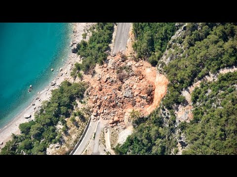
The terrain greatly affects landslide occurrence. Steep slopes are more likely to experience landslides because gravity pulls materials downward.
Unstable areas, such as those with fractured materials or thin soil over bedrock, are particularly vulnerable.
Climate conditions, like heavy rainfall or rapid snowmelt, contribute to erosion. Rivers can alter landscapes, destabilizing slopes over time.
In places like California and the Pacific Coastal Ranges, the combination of steep terrain and wet conditions increases landslide risk. Changes in temperature can also weaken soil structures, making them more prone to failure.
Role of Geology in Landslide Occurrence
Geological factors are central to understanding landslides. The type of material in an area plays a key role.
For instance, fractured rocks can fail under pressure, leading to landslides. Moreover, volcanic activity can destabilize slopes as ash and lava alter the ground’s composition.
Earthquakes are another significant geological trigger. They can cause immediate land shifts in regions like the Rocky Mountains and the Appalachian Mountains. These events highlight how geology integrates with the landscape. Understanding this relationship is vital for developing plans to minimize landslide risks, especially in known trouble spots.
Assessment and Management of Landslide Risks

Managing landslide risks involves careful mapping, strategic planning, and community preparedness. These steps are crucial to understanding where landslides are likely to occur and how to minimize their impact.
Mapping and Predicting Landslide Susceptibility
Mapping is essential for identifying areas prone to landslides. The U.S. Geological Survey (USGS) provides detailed landslide susceptibility maps that highlight regions at risk throughout the contiguous U.S. and Puerto Rico.
These maps utilize data such as topography, soil type, and vegetation cover to predict landslide activity.
Engineers and scientists analyze various factors that contribute to landslide potential. For instance, heavy rainfall, snowmelt, and volcanic eruptions can trigger mudflows and debris flows. Understanding these triggers enables better planning and response strategies.
Strategies for Landslide Mitigation
Effective landslide mitigation involves several strategies.
Land-use planning plays a vital role in reducing risks. By avoiding development in landslide-prone areas, planners can minimize potential damage.
Physical measures, such as drainage systems and slope stabilization techniques, help control water flow and prevent erosion. Engineers often recommend structural changes, like retaining walls, to support vulnerable slopes.
Regular monitoring of high-risk areas is also key to detecting early signs of landslide hazards.
Planning and Preparedness
Community preparedness is critical in managing landslide risks.
Establishing emergency response plans ensures that residents know what to do during a landslide.
Public education campaigns can raise awareness of the dangers of landslides and promote safety measures.
Additionally, local governments should conduct regular assessments of at-risk areas.
This allows for timely interventions, such as strengthening infrastructure or rerouting traffic away from vulnerable zones.
Collaborative efforts between engineers, planners, and local communities enhance overall preparedness and resilience to landslide hazards.