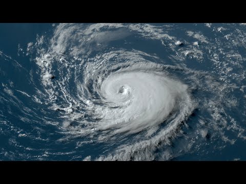
Hurricanes are complex natural phenomena, but they do not form by chance.
Hurricanes, also known as tropical cyclones or typhoons in different regions of the world, are created by a combination of warm ocean waters, low air pressure, and strong winds.
As warm, moist air rises, it creates a vacuum that draws in more air, leading to the formation of a powerful storm system.
These storms typically begin as tropical depressions and can develop into tropical storms with wind speeds of 39 miles per hour or higher. If conditions remain favorable, they can escalate into the massive hurricanes that can cause significant damage.
The storm surge and high winds associated with hurricanes can lead to severe flooding and destruction along coastlines, especially when they make landfall.
Understanding what creates hurricanes is essential for better predicting their paths and mitigating their impacts.
As the climate continues to change, these storms may become more intense, making it crucial for everyone to stay informed about their formation and potential effects.
Meteorological Mechanics of Hurricanes

Hurricanes are complex storm systems driven by specific meteorological factors. Understanding how they form and how they move is key to predicting their behavior.
Formation and Structure
Hurricanes typically begin as a tropical disturbance, a low-pressure system that fosters thunderstorms.
Warm ocean water, generally above 26°C (79°F), is crucial, as it serves as the storm’s energy source. This warmth causes moist air to rise, creating lower pressure at the surface.
As air flows into this low-pressure area, it spirals upward in a cumulonimbus cloud, resulting in a well-defined structure. The eye of the hurricane is the calm center surrounded by increasingly strong winds and towering clouds. Wind speeds can exceed 74 miles per hour, classifying the storm as a hurricane. The Coriolis effect helps in the rotation of storms, as they curve due to the Earth’s rotation.
Intensification and Movement
Once a hurricane forms, several factors influence its intensification and path.
Low wind shear allows the storm to grow stronger without disruption. As moist air rises, it releases latent heat, which fuels further intensification and leads to high wind speeds.
The storm often follows patterns dictated by larger wind patterns in the atmosphere.
In tropical areas, hurricanes may travel toward the coast, posing risks of wind damage and extreme weather conditions. Historical examples, such as Hurricane Katrina, showcase how rapidly these storms can intensify and change course, often making landfall with devastating impacts. Such movement is influenced by various meteorological elements, including pressure systems and geographical features.
Hurricane Impact and Monitoring

Hurricanes can have devastating effects on coastal areas, involving various hazards and damaging impacts. Monitoring these storms is crucial for effectively predicting their paths and minimizing potential destruction.
Hazards and Landfall Effects
Hurricanes bring multiple hazards, including storm surge, flooding, and wind damage.
Storm surge occurs when ocean water is pushed onto land, often leading to significant flooding in coastal regions. Areas along the Gulf of Mexico are particularly vulnerable to this effect.
When hurricanes make landfall, the damage can be severe. Tornadoes can spawn from the outer bands of a hurricane, causing additional destruction. The Eastern Pacific Ocean is home to many severe tropical cyclones, which can also impact land areas.
Key factors include:
- Wind Speeds: High winds can uproot trees and damage buildings.
- Rainfall: Intense rainfall can lead to flooding, affecting transportation and utilities.
Communities need to prepare for these risks well in advance of a storm’s arrival.
Prediction and Tracking Technologies
Advancements in prediction and tracking technologies have improved hurricane monitoring.
The National Oceanic and Atmospheric Administration (NOAA) plays a key role in this process. They analyze data from GOES satellites that provide real-time imagery of storms.
Weather forecasters utilize this data to enhance forecasting accuracy.
Knowledge of ocean surface temperatures in the Gulf of Mexico helps predict hurricane formation. These technologies not only aid in tracking current storms but also in studying patterns influenced by climate change.
Some key tools include:
- Satellite Imagery: Helps visualize storm structures.
- Computer Models: Predict future movements and strength changes.
These systems work together to inform the public and emergency services, allowing for better preparedness.
Understanding these technologies is essential for reducing the impacts of future hurricanes.

