
Storm systems in North America typically move from the west coast to the east coast due to the prevailing winds in the atmosphere.
The jet stream, a fast-flowing river of air high above the Earth, plays a crucial role in guiding these weather systems across the continent. These winds create a pathway that pushes storms along, leading to the familiar weather patterns seen in many regions.
As storms develop over the Pacific Ocean, they often contain moisture and energy that can lead to significant weather events. Once they reach the west coast, these systems are steered by the jet stream, moving eastward and impacting various areas along the way.
The geography of the United States also influences this movement, with mountains and valleys shaping weather patterns and affecting storm dynamics.
Weather systems are constantly influenced by various atmospheric phenomena, creating a complex interplay that dictates their movement. Understanding these dynamics helps meteorologists predict weather more accurately.
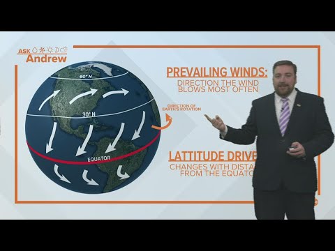
Mechanics of Atmospheric Circulation

Atmospheric circulation is driven by large-scale wind patterns that influence weather across the globe. Several key factors contribute to this process, including the jet stream, trade winds, and the Coriolis effect.
Each plays a crucial role in shaping the movement of storms from the west to the east coast of America.
Role of the Jet Stream
The jet stream is a fast-flowing air current located in the upper atmosphere. It generally moves from west to east and plays a significant role in guiding weather systems, including storms.
The position of the jet stream creates areas of low pressure, which can enhance storm development.
When the jet stream dips south or rises north, it influences where storms travel. This pattern is important for understanding how storms move across North America and can lead to severe weather conditions depending on its position.
Impact of the Trade Winds
Trade winds are consistent winds that blow from east to west near the equator. They help to drive weather systems across the Atlantic Ocean toward the east coast of the United States.
As these winds push warm, moist air, they create favorable conditions for storm formation.
The interaction between trade winds and other atmospheric currents helps to maintain the flow of tropical systems. These winds often lead to the development of hurricanes in the Atlantic, which can then track northward, influenced by the prevailing winds and other atmospheric forces.
Coriolis Effect and Weather Patterns
The Coriolis effect results from the Earth’s rotation, causing moving air to curve. This effect is essential in determining wind directions and patterns at various latitudes.
In the Northern Hemisphere, winds curve to the right, which impacts how storms move.
The interplay between the Coriolis effect and global wind patterns can create complex weather systems. The result is that storms originating from the tropics may travel northwest before being steered northeast toward the eastern United States. Understanding this effect is crucial for forecasting weather and predicting storm paths.
Ocean Influences on Storm Movement
The ocean plays a crucial role in influencing storm movement along the U.S. coast. Various factors, including ocean currents, water temperatures, and how these elements interact with storms, determine their paths and behaviors.
Gulf Stream’s Effect on Weather
The Gulf Stream is a powerful ocean current that flows from the Gulf of Mexico into the Atlantic Ocean. This warm current significantly impacts weather patterns along the East Coast.
As the Gulf Stream moves northward, it brings warm water that can intensify storms. When hurricanes travel over this warm water, they can gain strength, leading to more severe weather.
The Gulf Stream also affects the trajectory of storms. It can help steer hurricanes toward the northeast, often leading them away from the coast. Understanding this current is vital for predicting how storms will move across the Atlantic basin.
Interactions Between Ocean Currents and Storms
Ocean currents, like the Florida Current and the North Atlantic Current, interact with tropical storms and hurricanes as they approach the U.S. coast. These currents influence not only the storm’s speed but also its direction.
Storms can strengthen when they move over warm ocean waters, causing more evaporation and fueling the storm.
For instance, hurricanes that travel through the Caribbean Sea often gain strength due to the warm waters before moving into the Atlantic. Understanding the dynamic between ocean currents and storms is critical for accurate weather forecasting.
Sea Surface Temperatures and Tropical Storms
Sea surface temperatures (SST) are essential in determining tropical storm intensity. Warmer water temperatures lead to more powerful storms.
The Atlantic Ocean, especially in areas like the Gulf of Mexico, often sees temperatures that can exceed 80°F, providing ample energy for hurricanes.
In the Northeast Pacific basin, SST also plays a significant role. Anomalies in these temperatures can lead to more frequent or intense storms.
Regions with higher SSTs are often closely monitored during hurricane season, as they correlate strongly with storm development and intensity.
Understanding these factors is crucial for those studying and forecasting weather patterns, as they highlight how interconnected the ocean is with storm movement and behavior.
For further information about regional trends, visit Regional – ChaseDay.com.