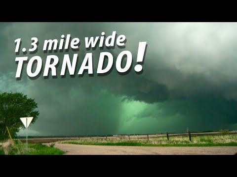
Supercells are unique types of thunderstorms that can produce severe weather, and they are often recognized by their striking green skies.
The green color usually indicates that a supercell is capable of producing large hail or heavy rainfall. This phenomenon happens due to the way light interacts with the storm’s structure and the water droplets within it.
Meteorologists have studied these storms extensively, noting that not all supercells display a green hue.
The green sky occurs when the storm’s updraft takes in moisture, which is illuminated from behind by the sun. The combination of the storm’s characteristics and environmental conditions plays a crucial role in this vibrant display.
Understanding why supercells turn green can help in predicting severe weather events, alerting communities to potential dangers.
Those who are fascinated by atmospheric phenomena may find that exploring the science behind these green skies leads to a deeper appreciation of thunderstorms and their effects on our environment.
The Science Behind Supercell Coloration

Supercells can exhibit striking colors, particularly shades of green. This coloration results from various factors related to light, atmospheric particles, and the presence of severe weather conditions.
Understanding Light Scattering
Light scattering is a key factor in how supercells appear. When sunlight penetrates a storm, it interacts with water droplets and ice in the atmosphere.
Blue light has a shorter wavelength and scatters more than other colors. This scattering can create vibrant blue hues that mix with the storm’s darker clouds, leading to a muted green appearance.
Additionally, the angle of sunlight impacts how light scatters within the storm. Overhead light can enhance the colors, particularly during late afternoon storms. As supercells develop and grow, this interplay of light and moisture creates their unique visual characteristics.
Role of Water Droplets and Hail
The presence of water droplets and hail plays a significant role in the color of supercells. Large hailstones, when present, can amplify the greenish tint in storms.
This occurs due to the way light reflects off and passes through these particles. Water droplets in heavy rain also contribute to the coloration.
When a supercell generates rain, the droplets create distortions in light, enhancing the green effect. The combination of moisture, hail, and varying light conditions results in a complex tapestry of colors that meteorologists associate with severe thunderstorms.
Severe Weather Indicators
Greenish skies are often linked with severe weather indicators in supercells. Meteorologists note that this coloration frequently appears in conjunction with the potential for heavy rain and large hail.
Specifically, research shows that storms displaying these colors can produce damaging winds and tornadoes.
Understanding this relationship helps meteorologists predict severe weather conditions. When a storm exhibits a green hue, it signals the potential for hazardous weather to those nearby. This correlation between color and severity underscores the importance of monitoring supercells closely as they develop.
Supercell Dynamics and Observation

Supercells are complex storm systems that exhibit unique behavior important for understanding their structure and impact. Key aspects include rotational characteristics, the interplay of updrafts and downdrafts, and insights relevant for storm chasers.
Rotational Characteristics
Supercells feature a rotating updraft called a mesocyclone. This rotation starts due to wind shear, which is the change in wind speed and direction at different heights. As winds blow at various levels, this creates a rolling effect in the atmosphere.
The rotation is essential for severe storms. It allows for the organization of the storm, which may lead to the formation of violent tornadoes. Radar reflectivity helps meteorologists identify these rotating structures. Recognizing the presence of a mesocyclone can alert storm chasers to the potential for significant weather events.
Understanding Downdrafts and Updrafts
In supercells, two main types of downdrafts are crucial: the forward flank downdraft (FFD) and the rear flank downdraft (RFD).
The FFD typically occurs on the storm’s leading edge, bringing heavy rain and sometimes hail. In contrast, the RFD forms behind the updraft, creating a critical zone where a wall cloud can develop.
Updrafts in supercells counterbalance these downdrafts. Strong updrafts lift warm, moist air into the storm, fueling its growth. The interaction between these forces shapes the storm’s structure, and when conditions are right, it can lead to the development of tornadoes. Storm chasers must monitor these dynamics closely.
Implications for Storm Chasers
For storm chasers, understanding supercell dynamics is vital.
Knowledge of rotational characteristics aids in identifying where a tornado might form.
Staying informed about updraft and downdraft locations can improve safety and increase the chances of witnessing meteoric events.
Chasers often rely on radar data to track supercell movements and patterns.
Evaluating storm behavior helps predict severe weather outcomes.
Resources like Electrical Storms provide updates on supercell activity to enhance situational awareness.
This understanding enables chasers to make informed decisions on intercepting storms while prioritizing their safety.
