
A “bomb cyclone” is a striking term that raises curiosity about its implications in weather forecasting. The term refers to a rapid drop in atmospheric pressure associated with a powerful storm, marking a process known as bombogenesis.
This phenomenon occurs when a cyclone intensifies quickly, often leading to extreme weather conditions that can be dangerous and disruptive.
Meteorologists watch for these major weather events because a bomb cyclone can bring severe wind, rain, and snow, especially during winter months.
The unique characteristics of bombogenesis occur when warm air collides with cold air, creating significant changes in pressure, which can result in intense storms. Understanding why these storms are called bomb cyclones provides insight into their nature and the impact they can have on communities.
With thirty years of experience in tracking extreme weather, it becomes evident that not all storms are created equal. The rapid intensification seen in bomb cyclones requires attention, as it can lead to sudden and hazardous conditions for those in the storm’s path.
The Science Behind Bomb Cyclones
Bomb cyclones are remarkable weather events characterized by rapid intensification. Understanding the science behind them involves several key concepts, including bombogenesis, atmospheric pressure changes, ocean influences, and the interactions between cold and warm air masses.
What Is Bombogenesis?
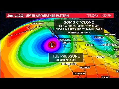
Bombogenesis refers to the process where a storm undergoes significant strengthening in a short time. Specifically, it happens when the central pressure of a cyclone drops by at least 24 millibars in 24 hours.
This rapid intensification can lead to severe weather conditions, including high winds and heavy rainfall. The name is derived from the term “bomb,” reflecting the explosive nature of these storms.
Conditions that contribute to bombogenesis often occur over oceans where warm ocean waters can supply moisture, which is crucial for cloud formation and precipitation.
Understanding Atmospheric Pressure Changes
Atmospheric pressure is a key factor in the development of bomb cyclones. When a cyclone forms, the pressure at its center drops, creating a difference in pressure between the low-pressure center and the surrounding area.
This pressure gradient drives strong winds, sometimes reaching hurricane force. As storms intensify, the lowering of pressure can lead to a rapid influx of energy.
In bomb cyclones, this drop can be very substantial, which contributes to their dangerous effects, including gusty winds and heavy precipitation, impacting areas far from the storm center.
Role of Ocean Waters in Cyclone Formation
Ocean waters play a crucial role in forming bomb cyclones. Warm sea surface temperatures provide essential heat and moisture, fueling the storm’s growth.
When moist air from the ocean rises and cools, it condenses to form clouds and precipitation, further lowering atmospheric pressure. The interaction between warm surface currents and colder air above contributes to the storm’s intensity.
Additionally, the ocean can enhance storm strength through processes like evaporation, which adds latent heat to the atmosphere. These interactions can lead to explosive development, known as explosive cyclogenesis, that defines a bomb cyclone.
Air Mass Interactions: Cold Versus Warm
Air mass interactions are vital to the formation of a bomb cyclone. Cold and warm air masses collide, creating instability within the atmosphere.
When warmer, moist air rises over colder, denser air, it leads to the development of strong convection currents. This collision of air masses is often pronounced during winter months, where warm, moist air from the ocean interacts with cold air from the land or polar regions.
This process not only facilitates rapid intensification of the storm but also plays a significant role in the precipitation patterns associated with bomb cyclones. Understanding these dynamics is crucial for predicting storm paths and potential impacts on affected regions.
Impacts of Bomb Cyclones on Weather and Society

Bomb cyclones can lead to significant effects on both weather patterns and societal conditions. Their rapid intensification can create extreme weather events, which in turn has a considerable impact on communities and the environment.
Predicting and Responding to Extreme Weather
The National Weather Service plays a crucial role in predicting bomb cyclones and their impacts. They use advanced technology to track changes in atmospheric pressure, which indicates the potential for severe storms.
Accurate forecasts can lead to timely warnings, informing the public about potential flooding, heavy snowfall, or blizzard conditions.
For instance, bomb cyclones can generate excessive rainfall and create an atmospheric river, leading to flash flooding. Areas like the Northwest Pacific and North Atlantic may face significant disruptions amidst major weather events. Preparedness plans, including high wind watches, help communities respond effectively to the challenges posed by these storms.
Societal and Environmental Effects
The societal effects of bomb cyclones are widespread. Heavy snow and ice can result in power outages, crippling transportation systems and trapping residents.
Cities may struggle to manage response efforts during severe rainfall, which can lead to flooding.
Additionally, these storms can disrupt daily life, causing schools and businesses to close. Communities must adapt to bitter cold and extreme conditions, often requiring the coordination of local emergency services.
Environmental impacts include soil erosion and damage to ecosystems from intense precipitation.
Awareness and preparation are vital for minimizing these risks, especially during winter storms or nor’easters.
Residents in vulnerable areas should remain informed about weather patterns to stay safe.
Those interested in understanding snow’s impact can read more about snow and ice. Understanding water management during storms is also essential, making insights about water relevant.